
Peterburgskoĭ Meridiany. (Петербургской меридианы.) 1810
- Regular price
-
$247.95 - Regular price
-
$242.95 - Sale price
-
$247.95
Shipping calculated at checkout.
Buy one map, get any other map in our collection for 50% OFF! Add to cart to see discount.
Couldn't load pickup availability
About This Map
Old map of Russian Federation, United States.
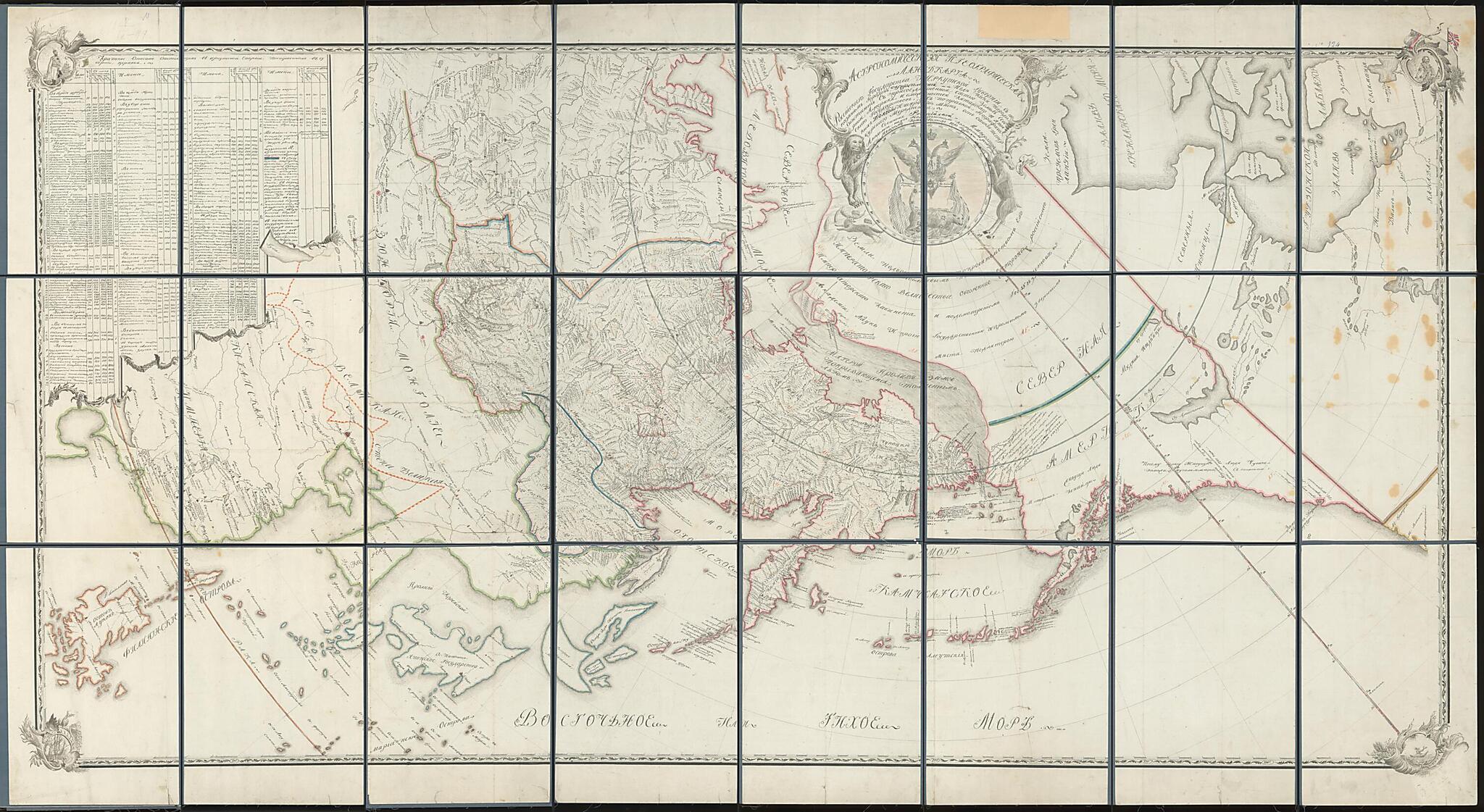
headed eagle holding the orb and scepter. The map also shows other regions of the Russian Empire to the west of Irkutsk, as well as adjacent parts of North America, China, and Japan. Colors delineate national boundaries, with a solid pink line outlining the entire eastern and northern borders of the Russian Empire, including Alaska (i.e., Russian America, where the eastern boundary with British North America is shown inaccurately). In contrast to the highly detailed Russian portions of the map, foreign lands are inaccurately represented, with far less precision and even missing elements. Parts of Alaska that the Russians had settled and explored extensively by the early 19th century, including the Aleutian Islands, Kodiak Island, and the Kenai Peninsula, are shown with much greater geographical specificity than adjoining inland regions of Alaska and North America. Southeastern regions of Alaska, which the Russians were only beginning to settle at this time, are also imperfectly represented. Northern areas of Alaska, especially within the Arctic, were poorly known by the Russians at this point and are entirely misrepresented on the map. A nonexistent large landmass stretching into the far north is placed where the Arctic Ocean is shown to the north of Alaska. The coast of China is shown inaccurately in places, while the islands of Japan are misrepresented in both shape and number. A bright dashed-yellow line indicates the Great Wall of China toward the center-left of the map. In the upper-left-hand corner are a series of tables that list the number of churches throughout eastern Russia, including local parish membership rolls by gender as well as a total count. There are two pictorial insets at the top of the map, an image of Tsar Alexander I in the upper-left-hand corner and one of Tsar Peter the Great in the upper-right-hand corner. Smaller insets can be seen at the bottom of the map: an image of a large ocean-going ship in the lower-left-hand corner and an image of a native Aleut hunting sea otter from a baidarka (Aleut or Unangan kayak) in the lower-right-hand corner. World Digital Library.
Created by Ivan Kozhevin in 1810.
- 24 panels mounted on canvas unfold to about 65" x 40". Large scale map, but fine detail of the Irkutsk region, e.g., listing all the churches.
- Sochinena Rossiĭskoĭ Akademii nauk geodezistom kollezhskim registratorom Ivanom Kozhevinym. Karta postroena v osoboĭ kosmicheskoĭ proekt︠s︡ii. Rossiĭskiĭ gerb pomeshchen na territorii Russkoĭ Ameriki i imeetsi︠a︡ pripiska "Zemli pod osoblivym pokrovitel'stvom ego Imperatorskogo Velichestva ...". Imeetsi︠a︡ tablit︠s︡a "kratkoe opisanie o sostoi︠a︡shchikh v Irkutskoĭ Eparkhii postroennykh v v gubernii, t︠s︡erkvi︠a︡kh". Karta pomeshchena v ramku, ukrashennui︠u︡ po uglam kartushami, v verkhnem levom uglu izobrazhen Aleksandr 1, v pravom verkhnem - Petr 1.
- Original map at: Russian State Library
- Сочинена Российской Академии наук геодезистом коллежским регистратором Иваном Кожевиным. Карта построена в особой космической проекции. Российский герб помещен на территории Русской Америки и имеется приписка "Земли под особливым покровительством его Императорского Величества ...". Имеется таблица "краткое описание о состоящих в Иркутской Епархии построенных в в губернии, церквях". Карта помещена в рамку, украшенную по углам картушами, в верхнем левом углу изображен Александр 1, в правом верхнем - Петр 1.
Map Subjects
Colonies
Russia
Russian Federation
Siberia
United States Of America
United States
Ivan Kozhevin
1810
Map Sizing Information
- For the best legibility, order your map in the original size or larger. Most maps have intricate detail and small text that is best appreciated when the print size hasn't been reduced.
- Sizes labeled "Fits a Standard Frame" will drop right into any frame that you purchase in that size. The sizes that we offer are commonly available online and at most retail stores.
- Our standard sizes are recommendations based on the aspect ratio of the original map, but still may require some added "white space" in one dimension to fit.
- Non-standard sizes will require custom framing, and we suggest taking your print to the frame shop of your choice after you receive it for the best results.
- Custom sizes are available, simply contact us for a quote.
Below is an approximation of the scale of a few standard sizes, and how they might appear in your space.
