
New and Accurate Map of Arabia, Asian Turkey, Etc.. (Nieuwe En Naukeurige Kaart Van Arabien Asiatisch Turkyen Enz) 1769
- Regular price
-
$54.95 - Regular price
-
$49.95 - Sale price
-
$54.95
Buy one map, get any other map in our collection for 50% OFF! Add to cart to see discount.
Couldn't load pickup availability
About This Map
Discover the timeless beauty of our fine art quality printed reproduction of this antique map. Perfect for history enthusiasts, collectors, and interior decorators.
Restored with meticulous attention to detail by our team with over a decade of experience, this stunning reproduction captures the intricate artistry and historical significance of the original map.
Whether you're a collector or seeking a unique decor piece, this archival-quality map reproduction is a timeless addition to any space. Order now to bring history to life!
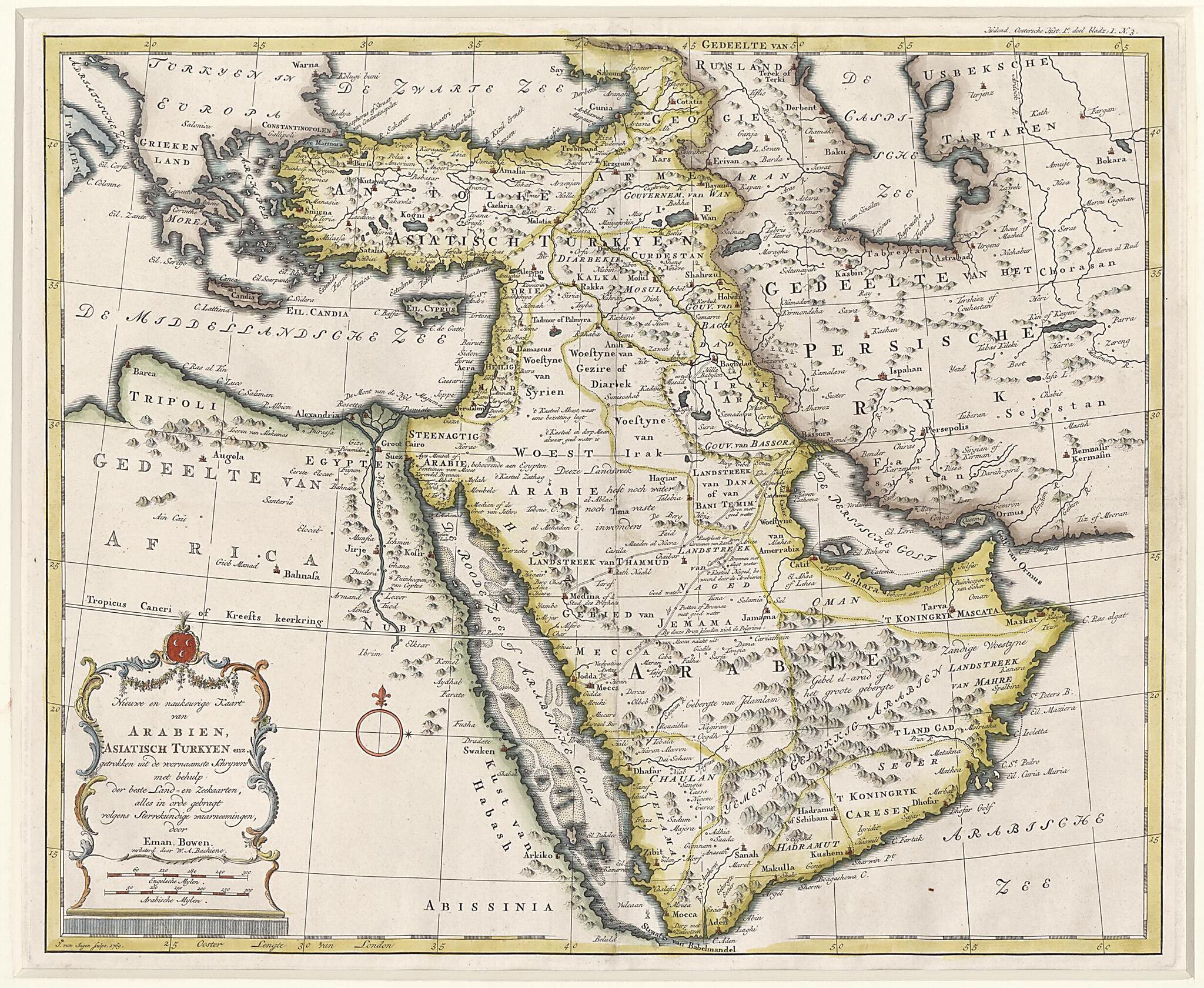
Old map of Armenia, Bahrain, Georgia, Iraq, Israel, Jordan, Kuwait, Lebanon, Oman, Qatar, Saudi Arabia, Syrian Arab Republic, Turkey, United Arab Emirates, Yemen.1767) enjoyed great renown as a cartographer, engraver, and publisher of maps. His prolific output and ability was recognized to such an extent that he was official engraver both to King George II of Great Britain and to King Louis XV of France. The map presented here was created and first engraved by Bowen, and it appeared in several of his publications in the 1740s, particularly A Complete System of Geography. This version of the map was engraved by Jan van Jagen of Amsterdam, and improved by Willem Albert Bachiene (1712-83), a Dutch geographer, astronomer, and preacher, who produced many maps of the Holy Land that appeared in 18th century Bibles. Relief is shown pictorially, and scale is indicated in English and Arabian miles. The title and scale are given in a decorative cartouche, and there is a small compass rose. The map shows major settlements, caravan routes, oases, and other geographic features. Much of the interior of Arabia remains somewhat fanciful but more accurate detail is beginning to emerge. However, the body of water to the west of the Arabian Peninsula labeled the "Red Sea or Arabian Gulf" is disproportionately wide and shown with many islands and pearl banks. In the area of Qatar is a town labeled "Catema," and two islands appear to signify Bahrain. Parts of northeast Africa are sketched in.
Created by Willem Albert Bachiene, Emanuel Bowen, Jan Van Jagen in 1769.
- Title devised, in English, by Library staff.
- "The map covers 21°-61°E., 13°-42°N.|Arabian Peninsula is divided into several regions. Negd (Najd), Chaulan (western Yemen), Yemen of Gelukkig Arabien, Hadramut, Seger, Oman, Bahara; routes from Bassora (Basra) to Jedda (Jiddah) and Mecca and from Basra to Medina and from Baghdad to Medina are traced."--Note extracted from World Digital Library.
- Original resource extent: 1 map : color ; 34 x 41 centimeters.
- Original resource at: Qatar National Library.
- Content in Dutch.
- Description based on data extracted from World Digital Library, which may be extracted from partner institutions.
Map Subjects
Arabian Gulf
Arabian Peninsula
Armenia
Bahrain
Georgia
Iraq
Israel
Jordan
Kuwait
Lebanon
Oman
Ottoman Empire
Persian Gulf
Qatar
Red Sea
Saudi Arabia
Syrian Arab Republic
Turkey
United Arab Emirates
Yemen
Willem Albert Bachiene
Emanuel Bowen
Jan Van Jagen
1769
- For the best legibility, order your map in the original size or larger. Most maps have intricate detail and small text that is best appreciated when the print size hasn't been reduced.
- Sizes labeled "Fits a Standard Frame" will drop right into any frame that you purchase in that size. The sizes that we offer are commonly available online and at most retail stores.
- Our standard sizes are recommendations based on the aspect ratio of the original map, but still may require some added "white space" in one dimension to fit.
- Non-standard sizes will require custom framing, and we suggest taking your print to the frame shop of your choice after you receive it for the best results.
- Custom sizes are available, simply contact us for a quote.
Below is an approximation of the scale of a few standard sizes, and how they might appear in your space.

