
North America Polar Regions, Baffin Bay to Lincoln Sea. (North America Polar Regions Baffin Bay to Lincoln Sea) 1903
- Regular price
-
$133.95 - Regular price
-
$128.95 - Sale price
-
$133.95
Buy one map, get any other map in our collection for 50% OFF! Add to cart to see discount.
Couldn't load pickup availability
About This Map
Discover the timeless beauty of our fine art quality printed reproduction of this antique map. Perfect for history enthusiasts, collectors, and interior decorators.
Restored with meticulous attention to detail by our team with over a decade of experience, this stunning reproduction captures the intricate artistry and historical significance of the original map.
Whether you're a collector or seeking a unique decor piece, this archival-quality map reproduction is a timeless addition to any space. Order now to bring history to life!
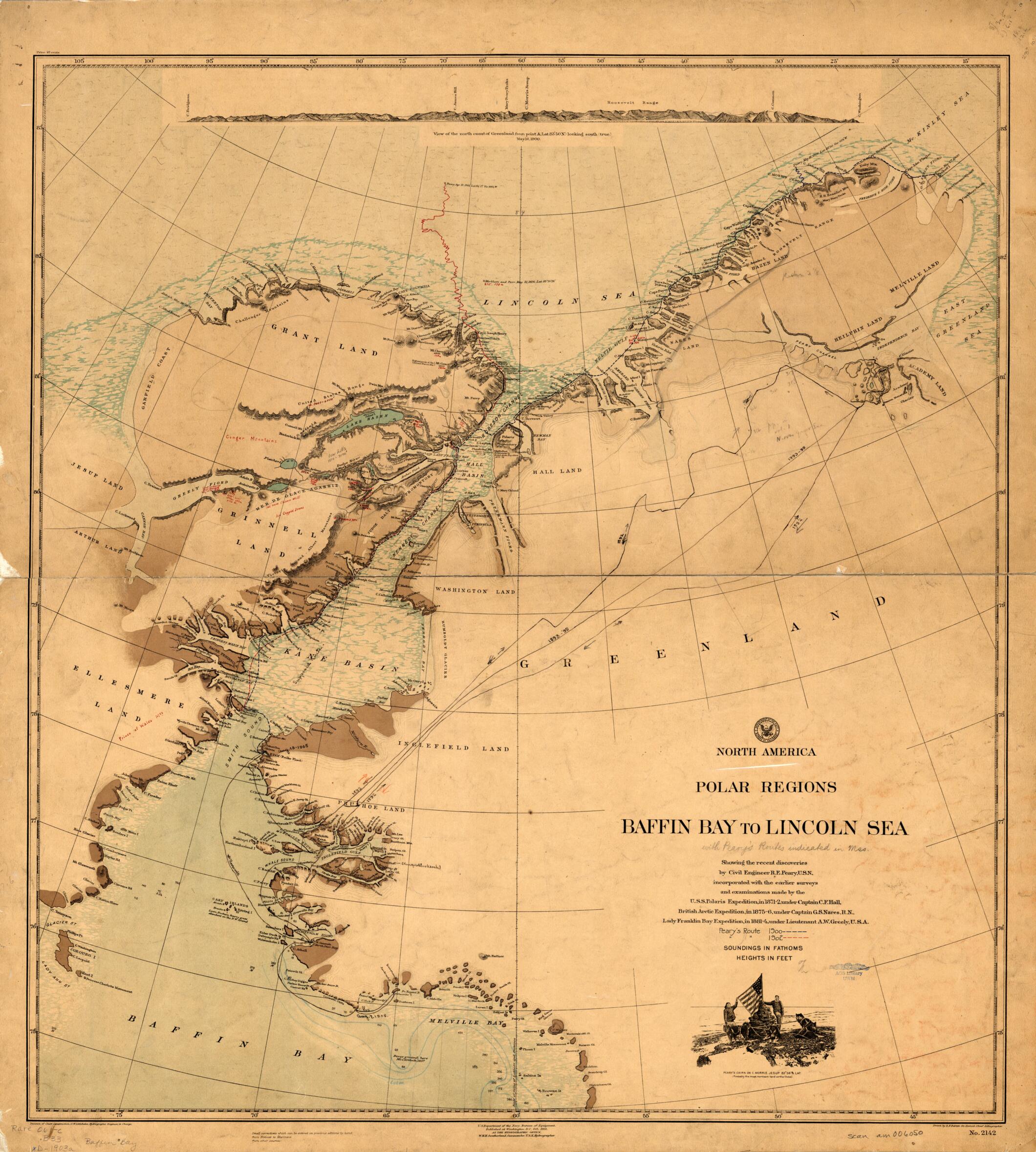
Old map of Canada, Denmark, Greenland, Nunavut.century British and American polar expeditions: the U.S.S. Polaris Expedition in 1871--72, under Captain C.F. Hall; the British Arctic Expedition in 1875--76, under Captain G.S. Nares, Royal Navy; and the Lady Franklin Bay Expedition in 1881--84, under Lieutenant A.W. Greely, U.S. Army. The map is annotated in red and blue to show two more recent expeditions led Robert E. Peary in 1900 and 1902. Relief is shown by contours, hachures, and spot elevations. Ocean depths are given in fathoms, heights in feet. The illustration at the top gives a view of the north coast of Greenland looking southward, with mountains shown in relief. Peary (1856--1920), a U.S. Navy officer, made a total of eight Arctic voyages, all starting from the west coast of Greenland. On his voyage of 1900, he reached and named Cape Morris Jesup at the northern tip of Greenland. The map includes an illustration of Peary and a companion raising the American flag over a cairn at the cape, which at 83° 39' North is identified as "probably the most northern land on the Globe." On this same voyage, Peary ventured for the first time onto the pack ice and traveled as far north as 84° 17' (the map shows 83° 50') before turning back. In 1906 Peary claimed a "furthest north" of 87° 06'. On yet another expedition, in 1909, Peary claimed, on April 7, finally to have reached the North Pole, at 90° North. He was accompanied by the African-American explorer Matthew Henson and four Greenland Eskimos, who had pushed off from the larger expedition comprised of seven Americans, 17 Eskimos, 19 sledges, and 133 dogs. Later analyses of Peary's personal log book and other evidence from the journey, however, have questioned his navigational record and raised doubts about whether he and Henson ever actually reached the pole.
Created by R. F. Barnes, Gregor Noetzel, William Henry Hudson Southerland, United States. Hydrographic Office. Division of Chart Construction in 1903.
- Title devised, in English, by Library staff.
- "Scale approximately 1:1,320,000"--Note extracted from World Digital Library.
- Original resource extent: 1 map : color, annotated ; 84 x 79 centimeters.
- Original resource at: University of Wisconsin-Milwaukee Libraries.
- Content in English.
- Description based on data extracted from World Digital Library, which may be extracted from partner institutions.
- For the best legibility, order your map in the original size or larger. Most maps have intricate detail and small text that is best appreciated when the print size hasn't been reduced.
- Sizes labeled "Fits a Standard Frame" will drop right into any frame that you purchase in that size. The sizes that we offer are commonly available online and at most retail stores.
- Our standard sizes are recommendations based on the aspect ratio of the original map, but still may require some added "white space" in one dimension to fit.
- Non-standard sizes will require custom framing, and we suggest taking your print to the frame shop of your choice after you receive it for the best results.
- Custom sizes are available, simply contact us for a quote.
Below is an approximation of the scale of a few standard sizes, and how they might appear in your space.

