
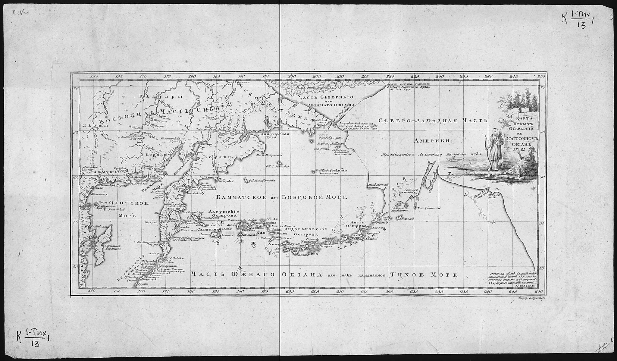
Karta Novykh Otkrytiĭ V Vostochnom Okeane. (Карта новых открытий в Восточном Океане.) 1781
- Regular price
-
$49.95 - Regular price
-
$34.95 - Sale price
-
$49.95
Buy one map, get any other map in our collection for 50% OFF! Add to cart to see discount.
Couldn't load pickup availability
About This Map
Discover the timeless beauty of our fine art quality printed reproduction of this antique map. Perfect for history enthusiasts, collectors, and interior decorators.
Restored with meticulous attention to detail by our team with over a decade of experience, this stunning reproduction captures the intricate artistry and historical significance of the original map.
Whether you're a collector or seeking a unique decor piece, this archival-quality map reproduction is a timeless addition to any space. Order now to bring history to life!
Old map of Alaska, Amur Oblast, Chukotka Autonomous Okrug, Khabarovsk Krai, Republic, Russian Federation, Sakha, Sakhalin Oblast, United States, Yakutiya.68 and several islands discovered by the English. Northeast of Bering Strait, in the far north of present-day Alaska, is a point reached by Cook in 1778 during his third voyage to the Pacific in his quest for the elusive Northwest Passage. It is marked on the map with the words: "Glorious Captain Cook reached this place in 1778." The map also points out areas inhabited by various ethnic groups with whom the Russian and European explorers made early contacts: Yakut, Koryak, Yukagir, and others. World Digital Library.
- Karta vostochnoĭ chasti Sibiri i severo-zapadnoĭ chasti Ameriki. Pokazany mesta, poseshchavshiesi︠a︡ geodezistom Gvozdevym v 1732 g., kapitanom Kukom v 1778 g.,.
- Original map at: National Library of Russia
- Карта восточной части Сибири и северо-западной части Америки. Показаны места, посещавшиеся геодезистом Гвоздевым в 1732 г., капитаном Куком в 1778 г.,.
Map Subjects
Alaska
Amur Oblast
Chukotka Autonomous Okrug
Cook James
Exploration And Encounters
Explorers
Khabarovsk Krai
Russian Federation
Sakha (Yakutiya) Republic
Sakhalin Oblast
Siberia
United States Of America
Voyages And Travels
Republic
Sakha
United States
Yakutiya
1781
- For the best legibility, order your map in the original size or larger. Most maps have intricate detail and small text that is best appreciated when the print size hasn't been reduced.
- Sizes labeled "Fits a Standard Frame" will drop right into any frame that you purchase in that size. The sizes that we offer are commonly available online and at most retail stores.
- Our standard sizes are recommendations based on the aspect ratio of the original map, but still may require some added "white space" in one dimension to fit.
- Non-standard sizes will require custom framing, and we suggest taking your print to the frame shop of your choice after you receive it for the best results.
- Custom sizes are available, simply contact us for a quote.
Below is an approximation of the scale of a few standard sizes, and how they might appear in your space.
