
North Atlantic Ocean: Northeastern Sheet portion 1922
- Regular price
-
$53.95 - Regular price
-
$48.95 - Sale price
-
$53.95
Buy one map, get any other map in our collection for 50% OFF! Add to cart to see discount.
Couldn't load pickup availability
About This Map
Discover the timeless beauty of our fine art quality printed reproduction of this antique map. Perfect for history enthusiasts, collectors, and interior decorators.
Restored with meticulous attention to detail by our team with over a decade of experience, this stunning reproduction captures the intricate artistry and historical significance of the original map.
Whether you're a collector or seeking a unique decor piece, this archival-quality map reproduction is a timeless addition to any space. Order now to bring history to life!
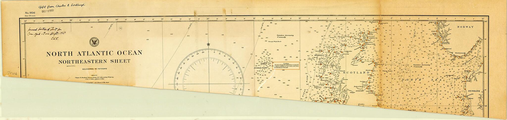
-74) used to plan his historic transatlantic flight. Lindbergh was an airmail pilot who, in 1926, learned of the $25,000 prize for the first nonstop flight between New York and Paris. Backed by a group of businessmen in St. Louis, Missouri, Lindbergh had a special plane built, which he named The Spirit of St. Louis in honor of his supporters. On May 21--22, 1927, Lindbergh achieved the first nonstop solo flight across the Atlantic, covering the 5,790 kilometers from Roosevelt Field, New York, to Le Bourget, Paris in 33.5 hours. This map shows the extreme measures that Lindbergh used to lighten his aircraft. To eliminate every ounce of unnecessary weight from his plane, Lindbergh went so far as to cut off sections of the map that he would not need on the flight. The annotations on the map read: "Unused portion of chart for New York to Paris flight--1927. C.A.L." and "Gift from Charles A. Lindbergh, Dec. 18, 1950."Created by Charles A. (Charles Augustus) Lindbergh, United States. Hydrographic Office in 1922.
- Title devised, in English, by Library staff.
- "Scale 1:5,300,000."--Note extracted from World Digital Library.
- Original resource extent: 1 map : color, annotated ; 27 x 11 centimeters.
- Original resource at: University of Wisconsin-Milwaukee Libraries.
- Content in English.
- Description based on data extracted from World Digital Library, which may be extracted from partner institutions.
Map Subjects
1922 To 1927
Flight
Nautical Charts
North Atlantic Ocean
Transatlantic Flights
Charles A. (Charles Augustus) Lindbergh
United States. Hydrographic Office
1922
- For the best legibility, order your map in the original size or larger. Most maps have intricate detail and small text that is best appreciated when the print size hasn't been reduced.
- Sizes labeled "Fits a Standard Frame" will drop right into any frame that you purchase in that size. The sizes that we offer are commonly available online and at most retail stores.
- Our standard sizes are recommendations based on the aspect ratio of the original map, but still may require some added "white space" in one dimension to fit.
- Non-standard sizes will require custom framing, and we suggest taking your print to the frame shop of your choice after you receive it for the best results.
- Custom sizes are available, simply contact us for a quote.
Below is an approximation of the scale of a few standard sizes, and how they might appear in your space.
