
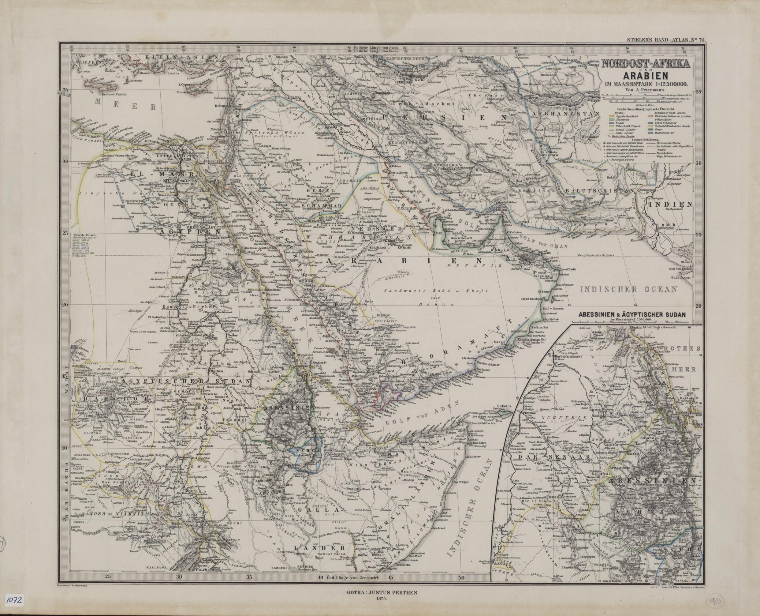
Northeast Africa and Arabia Drawn to the Scale of 1:12,500,000. (Afrika Und Arabien Im Maassstabe 1:12,500,000) 1875
- Regular price
-
$58.95 - Regular price
-
$53.95 - Sale price
-
$58.95
Buy one map, get any other map in our collection for 50% OFF! Add to cart to see discount.
Couldn't load pickup availability
About This Map
Discover the timeless beauty of our fine art quality printed reproduction of this antique map. Perfect for history enthusiasts, collectors, and interior decorators.
Restored with meticulous attention to detail by our team with over a decade of experience, this stunning reproduction captures the intricate artistry and historical significance of the original map.
Whether you're a collector or seeking a unique decor piece, this archival-quality map reproduction is a timeless addition to any space. Order now to bring history to life!
Old map of Bahrain, Djibouti, Egypt, Eritrea, Ethiopia, Iran, Islamic Republic of, Iraq, Israel, Jordan, Kuwait, Lebanon, Oman, Qatar, Saudi Arabia, Somalia, Sudan, Syrian Arab Republic, United Arab Emirates, Yemen.Atlas über alle Theile der Erde (Stieler's portable atlas of all parts of the Earth), edited by August Heinrich Petermann (1822-78) and published by the firm of Justus Perthes. The map reflects the high quality of German cartography in the latter part of the 19th century and the advances made by German mapmakers in incorporating into their work findings from geology, hydrography, ethnography, and other scientific fields. The map uses color codes to show the main political and ethnic divisions in Africa, Arabia, and western Asia. Three distance scales are given: German geographic miles, statute miles, and kilometers. The routes of recent European travelers are shown, including, on the Arabian Peninsula, Palgrave (1862), Pelly (1865), and J. Halévy (1870). Qatar is shown as Katar. In the lower right is a large inset map of Abyssinia (present-day Ethiopia) and Egyptian Sudan, the latter referring to territory along the Red Sea in present-day Eritrea and Sudan claimed at that time by Egypt.
Created by Fritz Hanemann, A. Kramer, Ernst Kuhn, A. (August Heinrich) Petermann, Adolf Stieler in 1875.
- Title devised, in English, by Library staff.
- "Scale 1:12,500,000 and 1:7,500,000 in inset"--Note extracted from World Digital Library.
- Original resource extent: 1 map ; 318 x 383 millimeters.
- Original resource at: Qatar National Library.
- Content in German.
- Description based on data extracted from World Digital Library, which may be extracted from partner institutions.
- For the best legibility, order your map in the original size or larger. Most maps have intricate detail and small text that is best appreciated when the print size hasn't been reduced.
- Sizes labeled "Fits a Standard Frame" will drop right into any frame that you purchase in that size. The sizes that we offer are commonly available online and at most retail stores.
- Our standard sizes are recommendations based on the aspect ratio of the original map, but still may require some added "white space" in one dimension to fit.
- Non-standard sizes will require custom framing, and we suggest taking your print to the frame shop of your choice after you receive it for the best results.
- Custom sizes are available, simply contact us for a quote.
Below is an approximation of the scale of a few standard sizes, and how they might appear in your space.

