
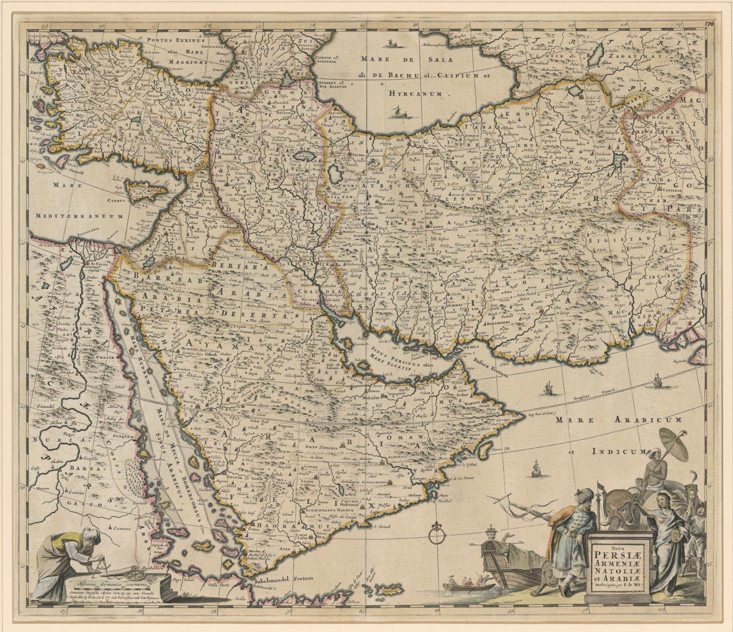
New Persia, Armenia, Anatolia and Arabia. (Nova Persiæ, Armeniæ, Natoliæ, Et Arabiæ) 1666
- Regular price
-
$83.95 - Regular price
-
$78.95 - Sale price
-
$83.95
Buy one map, get any other map in our collection for 50% OFF! Add to cart to see discount.
Couldn't load pickup availability
About This Map
Discover the timeless beauty of our fine art quality printed reproduction of this antique map. Perfect for history enthusiasts, collectors, and interior decorators.
Restored with meticulous attention to detail by our team with over a decade of experience, this stunning reproduction captures the intricate artistry and historical significance of the original map.
Whether you're a collector or seeking a unique decor piece, this archival-quality map reproduction is a timeless addition to any space. Order now to bring history to life!
Old map of Afghanistan, Armenia, Azerbaijan, Bahrain, Djibouti, Egypt, Eritrea, Iran, Islamic Republic of, Iraq, Jordan, Kuwait, Lebanon, Oman, Pakistan, Qatar, Saudi Arabia, Sudan, Syrian Arab Republic, Turkey, Turkmenistan, United Arab Emirates, Yemen.1706). It was published in Amsterdam in about 1666. The map covers the regions from present-day Turkey and Egypt to Afghanistan and the Arabian Peninsula, the Red Sea, the Nile River, Cyprus, Asia Minor, the Gulf of Aden, Armenia, the Caspian Sea, and the Indian Ocean. Unlike in many antique maps of the area, a great amount of geographic information is shown throughout the Arabian Peninsula, including the locations of cities, towns, rivers, and mountain ranges. The details in this map can be attributed to Nicolas Sanson's map of 1654, called Carte des Trois Arabies, which is widely regarded as one of the largest-scale and most detailed maps of the region of its day. The decorative title cartouche features several exotic figures and animals and a merchant ship with its boat. De Wit was born in Gouda and moved to Amsterdam, where he maintained his shop on the Kalverstraat. His works included sea and world atlases, wall maps, and town books containing plans of Dutch and European cities. Some time after 1674 he acquired the copper plates of town books by Johannes Janssonius and Joan Blaeu. In 1688, he obtained from the States General, the Dutch government of the day, the privilege to publish his maps. De Wit's maps were in demand throughout Europe and were sold until 1763 by the firm of Johannes Covens and Corneille Mortier.
Created by Nicolas Sanson, Frederik De Wit in 1666.
- Title devised, in English, by Library staff.
- "Scale approximately 1:8,750,000"--Note extracted from World Digital Library.
- Original resource extent: 1 map : color ; 43 x 54 centimeters.
- Original resource at: Qatar National Library.
- Content in Latin.
- Description based on data extracted from World Digital Library, which may be extracted from partner institutions.
- For the best legibility, order your map in the original size or larger. Most maps have intricate detail and small text that is best appreciated when the print size hasn't been reduced.
- Sizes labeled "Fits a Standard Frame" will drop right into any frame that you purchase in that size. The sizes that we offer are commonly available online and at most retail stores.
- Our standard sizes are recommendations based on the aspect ratio of the original map, but still may require some added "white space" in one dimension to fit.
- Non-standard sizes will require custom framing, and we suggest taking your print to the frame shop of your choice after you receive it for the best results.
- Custom sizes are available, simply contact us for a quote.
Below is an approximation of the scale of a few standard sizes, and how they might appear in your space.

