
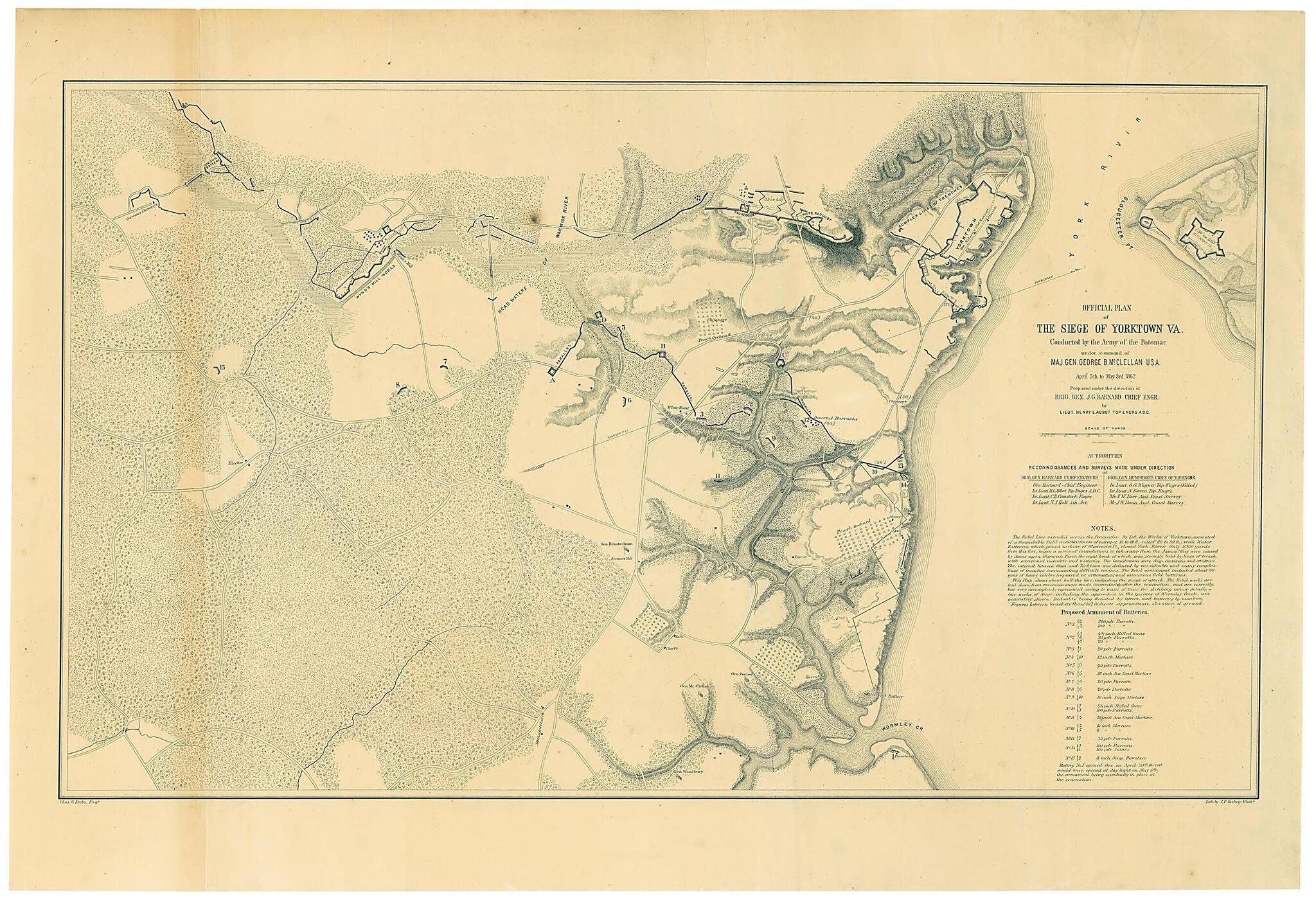
Official Plan of the Siege of Yorktown, Va. : Conducted by the Army of the Potomac Under Command of Maj. Gen. George B. McClellan U.S.A., April 5th to May 3rd 1862
- Regular price
-
$78.95 - Regular price
-
$73.95 - Sale price
-
$78.95
Buy one map, get any other map in our collection for 50% OFF! Add to cart to see discount.
Couldn't load pickup availability
About This Map
Discover the timeless beauty of our fine art quality printed reproduction of this antique map. Perfect for history enthusiasts, collectors, and interior decorators.
Restored with meticulous attention to detail by our team with over a decade of experience, this stunning reproduction captures the intricate artistry and historical significance of the original map.
Whether you're a collector or seeking a unique decor piece, this archival-quality map reproduction is a timeless addition to any space. Order now to bring history to life!
Old map of United States, Virginia, Williamsburg, York County, Yorktown.Created by Henry L. Abbot, J. F. Gedney, Charles G. Krebs, United States. Army. Corps of Engineers in 1862.
- Contains a list of the "proposed armament of batteries."
- Description derived from published bibliography.
- Indicates headquarters of Generals McClellan, Porter, Woodbury, and Heintzelman, houses, names of residents, roads, drainage, vegetation, and relief by hachures and spot heights.
- Oriented with north to upper right.
- This item is in the Map Collection of the Library of Virginia; please contact the Library's Archives Research Services department for more information.
- Civil War Map
- Swem, E.G. Maps relating to Virginia, 977
- C. 1 Jan. 1913, Libbie, b; c. 2 source unknown; c. 3 photocopy, LVA; Map Cataloging Team.
- C. 1, Map accession no. 943 (1913); c. 2 map accession no. 5216x; c. 3 (on 2 sheets, negative photostats, sheets 45 x 40 cm.)
- Civil War project no.: lva00124.
- Conservation: Etherington Conservation Center, April 2003.
- Digital image available: 21 x 30.5 in.
- Previously filed as: 755.412 M6 1861-1865 1862
Map Subjects
Civil War
History
Siege
United States
Virginia
Williamsburg
Williamsburg Battle Of Williamsburg Va.
York County
York County (Va.)
Yorktown
Yorktown (Va.)
Henry L. Abbot
J. F. Gedney
Charles G. Krebs
United States. Army. Corps Of Engineers
1862
- For the best legibility, order your map in the original size or larger. Most maps have intricate detail and small text that is best appreciated when the print size hasn't been reduced.
- Sizes labeled "Fits a Standard Frame" will drop right into any frame that you purchase in that size. The sizes that we offer are commonly available online and at most retail stores.
- Our standard sizes are recommendations based on the aspect ratio of the original map, but still may require some added "white space" in one dimension to fit.
- Non-standard sizes will require custom framing, and we suggest taking your print to the frame shop of your choice after you receive it for the best results.
- Custom sizes are available, simply contact us for a quote.
Below is an approximation of the scale of a few standard sizes, and how they might appear in your space.
