
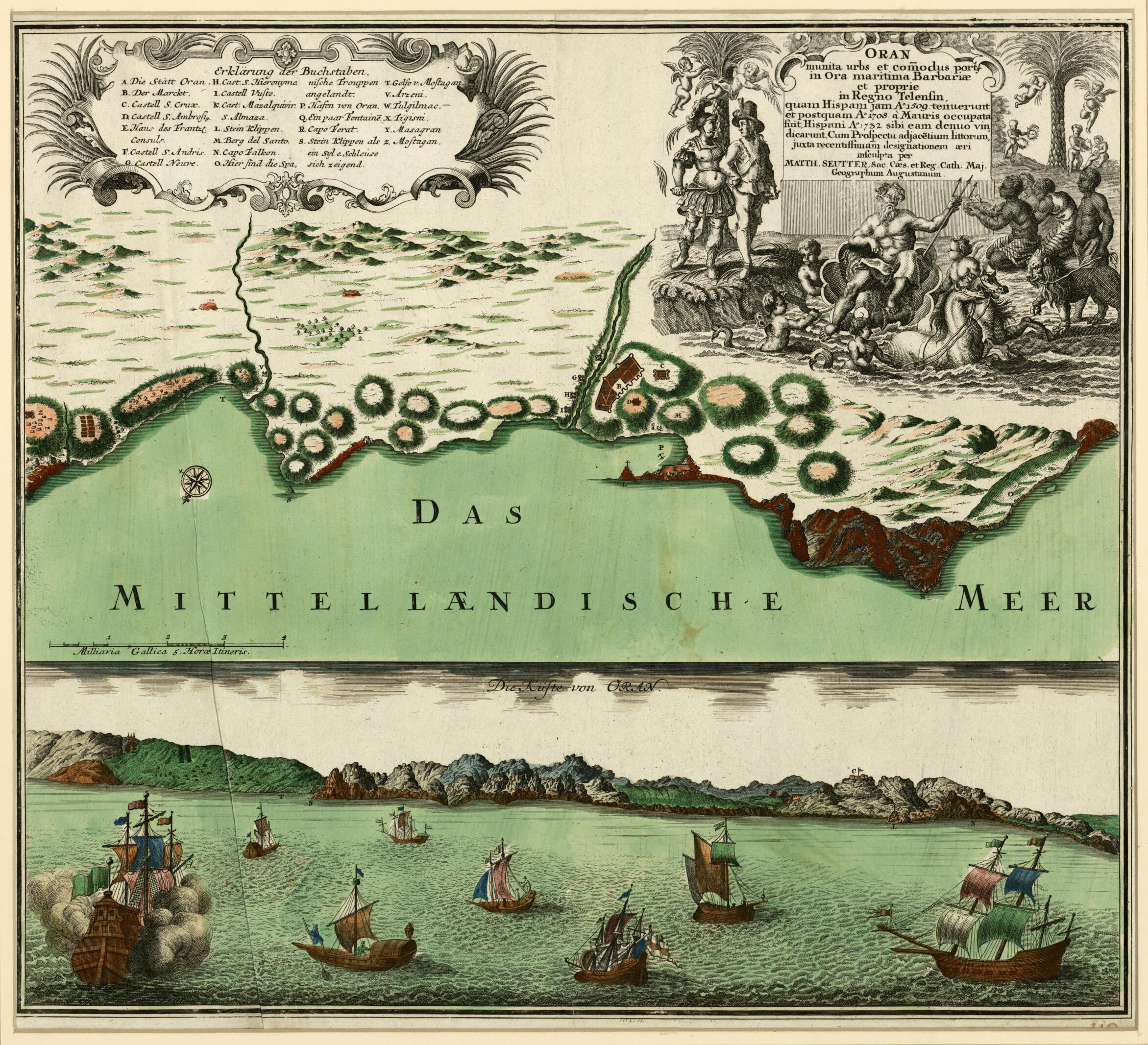
The Fortified City of Oran With Its Port On the Barbary Coast. (Oran Munita Urbs Et Comodus Porta In Ora Maritimae Barbariae Et Proprie In Regno Telensin, Quam Hispani Iam Ao 1509 Tenuerunt Et Postquam Ao 1708 a Mauris Occupata Fuit, Hispani Ao 1732 S...
- Regular price
-
$82.95 - Regular price
-
$77.95 - Sale price
-
$82.95
Buy one map, get any other map in our collection for 50% OFF! Add to cart to see discount.
Couldn't load pickup availability
About This Map
Discover the timeless beauty of our fine art quality printed reproduction of this antique map. Perfect for history enthusiasts, collectors, and interior decorators.
Restored with meticulous attention to detail by our team with over a decade of experience, this stunning reproduction captures the intricate artistry and historical significance of the original map.
Whether you're a collector or seeking a unique decor piece, this archival-quality map reproduction is a timeless addition to any space. Order now to bring history to life!
Old map of Algeria, Oran.part map and view of the town of Oran, in the northwest of present-day Algeria, was created in 1750 by Matthaeus Seutter (1678-1756). Seutter was apprenticed to the Nuremberg mapmaker Johan Baptist Homann (1663-1724) at the end of the 17th century. He returned to his home in Augsburg, where in 1707 he established his own publishing company and produced globes, maps and atlases. In 1715 he became geographer to Charles VI, the Holy Roman Emperor. The splendid allegorical cartouche of the map, showing Zeus in a chariot attended by courtiers, natives, and cherubs, gives Seutter's imperial title. Seutter and the rival firm of his former teacher Homann both were exemplars of the high south German baroque, with its emphasis on decorative embellishment. Oran was established in the tenth century by Moorish Andalusian merchants. In 1509 Cardinal Cisneros commanded a Castilian expedition that captured the city for Spain. It was conquered by the Turks in 1708, but in 1732 was reconquered by the Spanish, who sought to put an end to the marauding by the Barbary pirates based in the city. The upper part of the work is a bird's-eye view of Oran, with north oriented to the lower left, showing the market, fortifications, churches, the French consul's house, the place where the Spanish landed, cliffs, the harbor, and other sites. The lower half is a panorama of the coast with a fleet of colorful ships in the foreground. The legend at top left has a key that refers to significant places on both parts of the map. The scale is given in French miles.
Created by Matthaeus Seutter in 1750.
- Title devised, in English, by Library staff.
- Original resource extent: 1 map : color ; 35 x 49 centimeters.
- Original resource at: Qatar National Library.
- Content in German and Latin.
- Description based on data extracted from World Digital Library, which may be extracted from partner institutions.
- For the best legibility, order your map in the original size or larger. Most maps have intricate detail and small text that is best appreciated when the print size hasn't been reduced.
- Sizes labeled "Fits a Standard Frame" will drop right into any frame that you purchase in that size. The sizes that we offer are commonly available online and at most retail stores.
- Our standard sizes are recommendations based on the aspect ratio of the original map, but still may require some added "white space" in one dimension to fit.
- Non-standard sizes will require custom framing, and we suggest taking your print to the frame shop of your choice after you receive it for the best results.
- Custom sizes are available, simply contact us for a quote.
Below is an approximation of the scale of a few standard sizes, and how they might appear in your space.

