
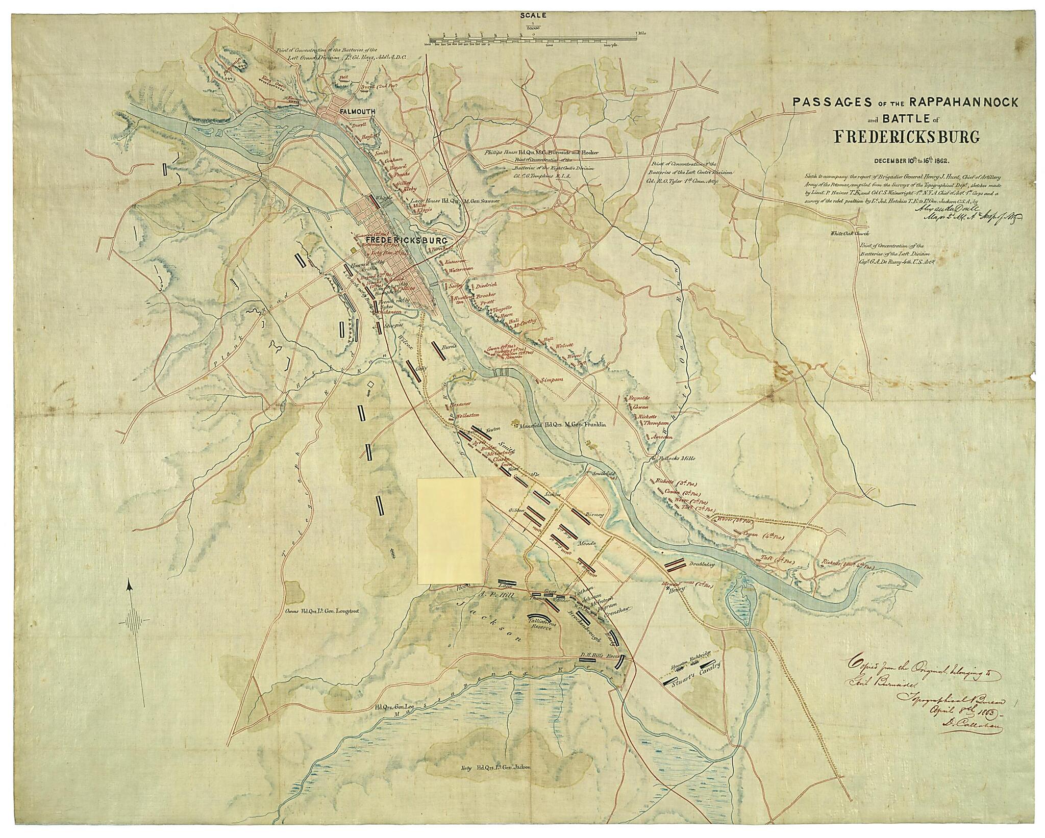
Passages of the Rappahannock and Battle of Fredericksburg, December 10th to 16th, 1862 : Copied from the Original Belonging to Gen'l. Burnside 1863
- Regular price
-
$115.95 - Regular price
-
$110.95 - Sale price
-
$115.95
Shipping calculated at checkout.
Buy one map, get any other map in our collection for 50% OFF! Add to cart to see discount.
Couldn't load pickup availability
About This Map
Old map of Fredericksburg, Fredericksburg Region, United States, Virginia.
Created by Denis Callahan, Alexander Doull, Peter C. (Peter Conover) Hains, Jedediah Hotchkiss, United States. Topographical Bureau, Charles S. (Charles Shiels) Wainwright in 1863.
Created by Denis Callahan, Alexander Doull, Peter C. (Peter Conover) Hains, Jedediah Hotchkiss, United States. Topographical Bureau, Charles S. (Charles Shiels) Wainwright in 1863.
- "Map originally prepared following the Battle of Fredericksburg in December 1862 ... enhanced by the addition of details from a captured map prepared by topographical engineer Jedediah Hotchkiss for the use of Confederate lietenant general Stonewall Jackson. A significant feature of the map is an overlay (overleaf) depicting the rapidly changing positions of Federal troops during and after their successful crossing of the Rappahannock River"--Virginia in maps, 2000 (atlas).
- "Sketch to accompany the report of Brigadier General Henry J. Hunt, chief of artillery, Army of the Potomac, compiled from the surveys of the Topographical Dept., sketches made by Lieut. P. Haines [i.e. , Hains] T.E., and Col. C.S. Wainwright 1st N.Y.A., Chief of Arty. 1st Corps and a survey of the rebel position by Lt. Jed. Hotchkiss T.E. to Lt. Gen. Jackson C.S.A., by [signed] Alexander Doull, Major 2d N.Y. Ay. Insp. of Arty."
- Oriented with north toward the upper left.
- Relief shown by hachures and shading.
- Shows Federal and Confederate positions, headquarters of commanding generals, batteries, woodland, and marsh areas.
- Similar to no. 2.239, Guide to Civil War maps in the National Archives.
- This item is in the Map Collection of the Library of Virginia; please contact the Library's Archives Research Services department for more information.
- Copy of original version belonging to General Burnside: Alexander Doull. 1862. 66 x 76 cm.
- C.1, Oct. 2001, source unknown (1968), gift, ALE; c.2, photocopy, LVA, ALE.
Map Subjects
Civil War
Fredericksburg (Va.) Battle Of
Fredericksburg Region (Va.)
Fredericksburg Va. Battle Of
History
United States
Virginia
Fredericksburg
Fredericksburg Region
Denis Callahan
Alexander Doull
Peter C. (Peter Conover) Hains
Jedediah Hotchkiss
United States. Topographical Bureau
Charles S. (Charles Shiels) Wainwright
1863
Map Sizing Information
- For the best legibility, order your map in the original size or larger. Most maps have intricate detail and small text that is best appreciated when the print size hasn't been reduced.
- Sizes labeled "Fits a Standard Frame" will drop right into any frame that you purchase in that size. The sizes that we offer are commonly available online and at most retail stores.
- Our standard sizes are recommendations based on the aspect ratio of the original map, but still may require some added "white space" in one dimension to fit.
- Non-standard sizes will require custom framing, and we suggest taking your print to the frame shop of your choice after you receive it for the best results.
- Custom sizes are available, simply contact us for a quote.
Below is an approximation of the scale of a few standard sizes, and how they might appear in your space.

