
Vostochnai︠a︡ Chast' I︠A︡kutskogo Uezda. (Восточная часть Якутского уезда.) 1772
- Regular price
-
$64.95 - Regular price
-
$59.95 - Sale price
-
$64.95
Buy one map, get any other map in our collection for 50% OFF! Add to cart to see discount.
Couldn't load pickup availability
About This Map
Discover the timeless beauty of our fine art quality printed reproduction of this antique map. Perfect for history enthusiasts, collectors, and interior decorators.
Restored with meticulous attention to detail by our team with over a decade of experience, this stunning reproduction captures the intricate artistry and historical significance of the original map.
Whether you're a collector or seeking a unique decor piece, this archival-quality map reproduction is a timeless addition to any space. Order now to bring history to life!
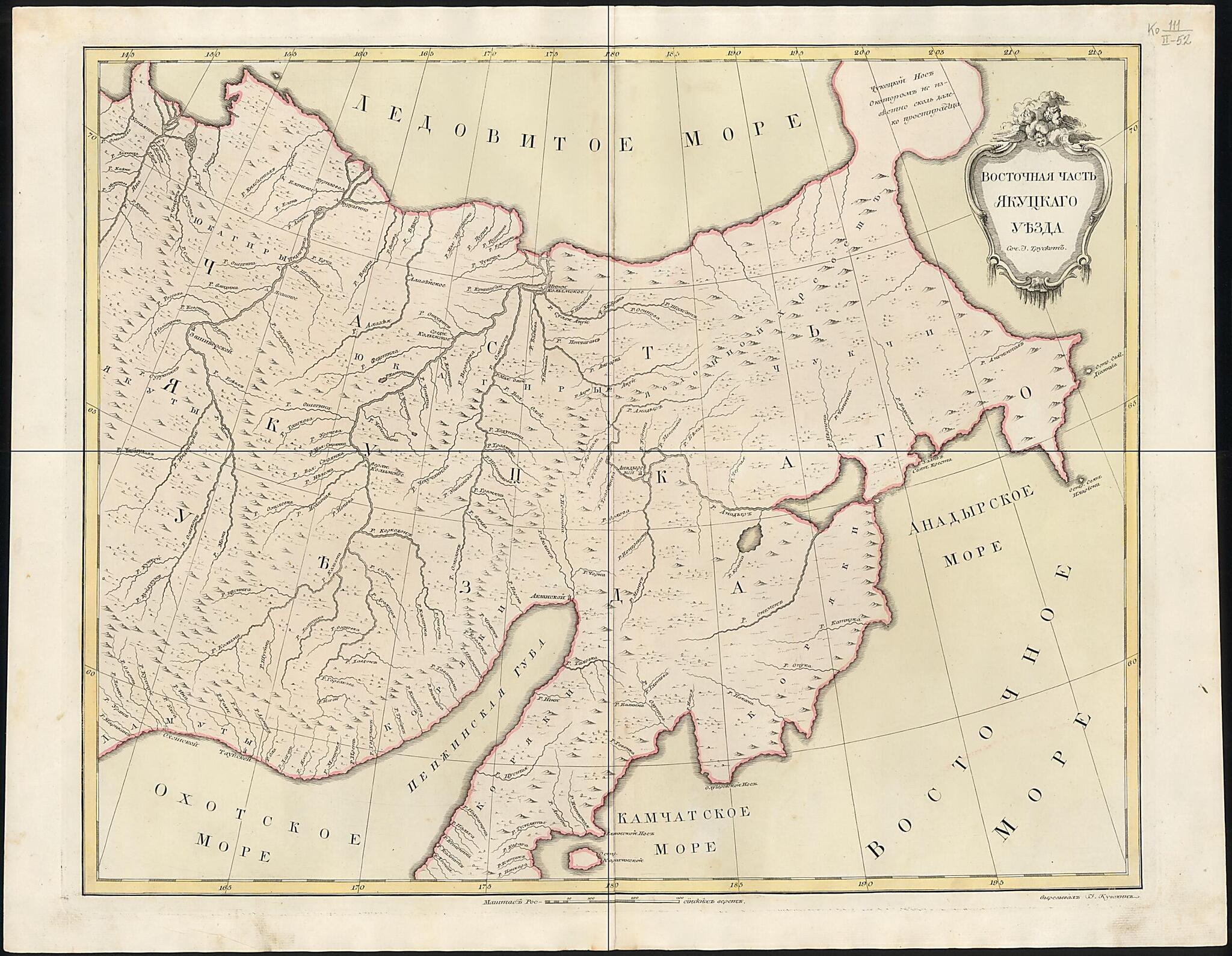
Old map of Chukotka Autonomous Okrug, Kamchatka Krai, Magadan Oblast, Russian Federation.day Chukotskiy Autonomous Okrug) and the northern portion of the Kamchatka Peninsula. It was compiled by Johann Treskot (1719-86) and engraved by Ivan Kuvakin in 1772. Treskot was a talented geodesist, affiliated with the Geographical Department of the Russian Academy of Sciences. The area of Russia depicted on this map extends from the mouth of the Yana River on the Arctic Ocean, in the upper-left-hand corner, to the city of Okhotsk on the Pacific coast, in the lower-left-hand corner, to Chukotka in the upper right-hand corner and the northern part of the Kamchatka Peninsula in the lower center. The Sea of Okhotsk is shown on the lower left-hand corner of the map, the Pacific (or Eastern) Ocean to the right, and the Arctic Ocean at the top. A few mountain chains are named, as are scattered Russian settlements and population centers. Some regional native cultures are listed, such as the Yukaghirs on the top left of the map, and the Chukchi to the right. Land relief and vegetation are shown by shading. Rivers and many tributaries are indicated, as are bodies of water and other geographical points of interest. The farthest northeastern tip of Russia is significantly misrepresented in size and shape, invariably because of its remote location and infrequent visitation by explorers and geographers to that point. The map indicates distance in versts, a tsarist-era unit of length equal to 1.07 kilometers. World Digital Library.
Created by Ivan Kuvakin, Johann Treskot in 1772.
- Sochinil I.Truskot, vyrezyval Ivan Kuvakin. Na karte uslovno izobrazhen Chukotskiĭ poluostrov. Karta sostavlena izvestnym russkim kartografom iz plei︠a︡dy Pergovskikh geodezistov Ivanom Truskotom, i︠a︡vli︠a︡i︠u︡shchimsi︠a︡ ad"i︠u︡tantom po Geograficheskomu departamentu Peterburgskoĭ Akademii nauk.
- Original map at: Russian State Library
- Сочинил И.Трускот, вырезывал Иван Кувакин. На карте условно изображен Чукотский полуостров. Карта составлена известным русским картографом из плеяды Перговских геодезистов Иваном Трускотом, являющимся адъютантом по Географическому департаменту Петербургской Академии наук.
Map Subjects
Chukchi Peninsula (Russia)
Chukotka Autonomous Okrug
Kamchatka Krai
Magadan Oblast
Russian Federation
Siberia
Ivan Kuvakin
Johann Treskot
1772
- For the best legibility, order your map in the original size or larger. Most maps have intricate detail and small text that is best appreciated when the print size hasn't been reduced.
- Sizes labeled "Fits a Standard Frame" will drop right into any frame that you purchase in that size. The sizes that we offer are commonly available online and at most retail stores.
- Our standard sizes are recommendations based on the aspect ratio of the original map, but still may require some added "white space" in one dimension to fit.
- Non-standard sizes will require custom framing, and we suggest taking your print to the frame shop of your choice after you receive it for the best results.
- Custom sizes are available, simply contact us for a quote.
Below is an approximation of the scale of a few standard sizes, and how they might appear in your space.

