Buy one map, get one map 50% off! Discount shown in cart.
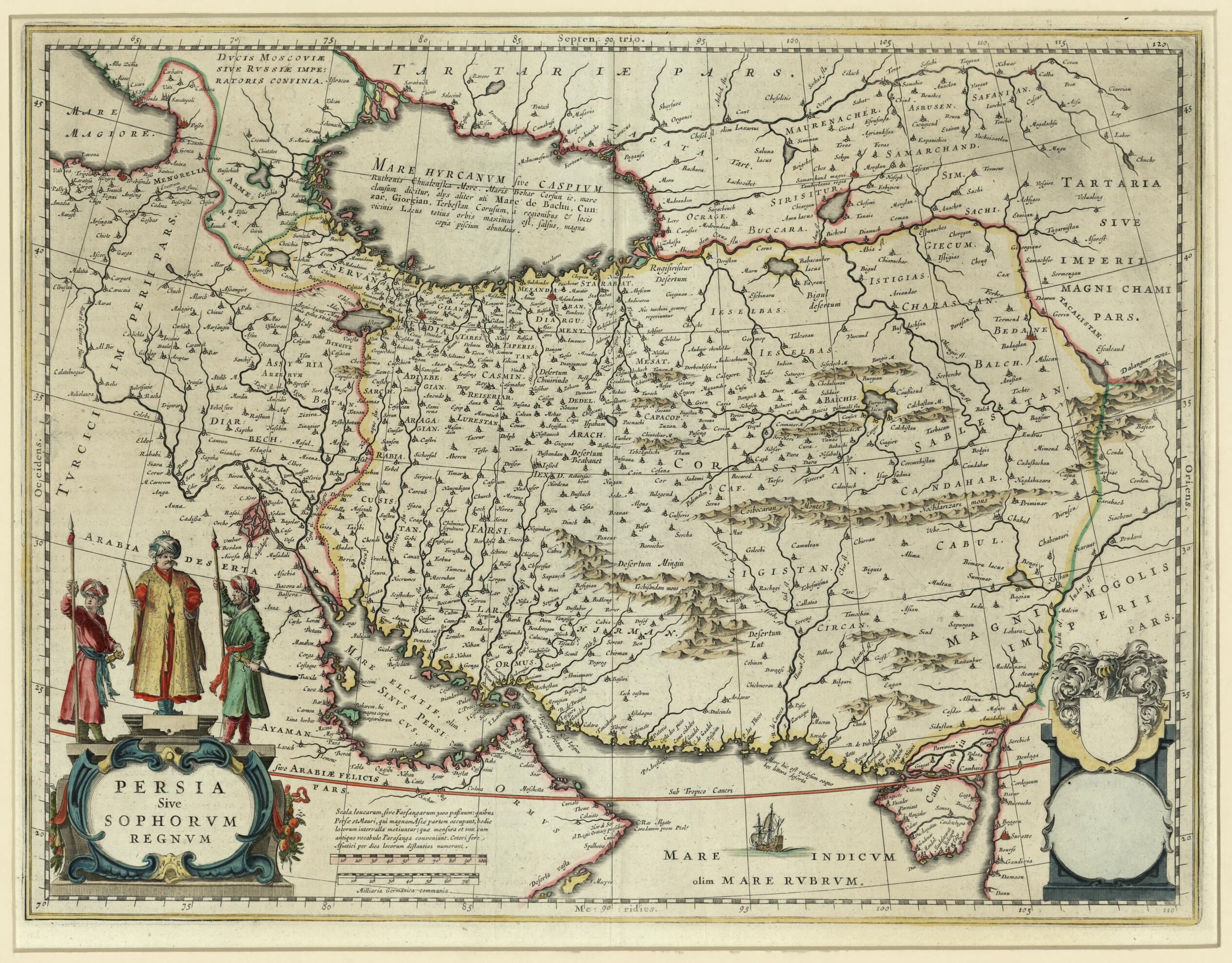
Persia, Or the Safavid Kingdom. (Persia Sive Sophorum Regnum) 1635
- Regular price
-
$64.95 - Regular price
-
$64.95 - Sale price
-
$64.95
Shipping calculated at checkout.
Couldn't load pickup availability
About This Map
Old map of Afghanistan, Armenia, Azerbaijan, Bahrain, Georgia, Iran, Islamic Republic of, Kuwait, Oman, Qatar, Saudi Arabia, Turkmenistan, United Arab Emirates.
1638), a Dutch cartographer, globe maker, and publisher. Blaeu trained with the Danish astronomer Tycho Brahe and began producing maps and charts in the early years of the 17th century. In 1633 he became the official cartographer for the Vereenigde Oost-Indische Compagnie (VOC--Dutch East India Company). Blaeu is best known for his Theatrum Orbis Terrarum sive Atlas Novus (New map and atlas of the world), published in Amsterdam in 1635, of which this hand-colored map formed part. It shows Persia extending from the eastern Mediterranean to the Indus River, with the Red Sea and the Persian Gulf in the south, and the Caspian Sea, Russia, and Tartary in the north. The map shows Safavid Persia at the height of its power. It includes areas of present-day Iran, Iraq, Armenia, Azerbaijan, Georgia, Turkmenistan, Afghanistan, Oman, Bahrain, Saudi Arabia, and Kuwait. Hundreds of towns and cities are noted, as well as rivers, lakes, mountain ranges, and turquoise mines. A decorative title cartouche shows a Persian ruler with two guards holding spears and swords; a sailing ship is seen in the Indian Ocean. The two scales are in German common miles and in parasangs (the Persian equivalent of leagues). Willem Janzoon's son, Joan Blaeu (1596-1673), continued publishing maps and atlases, including the Atlas Blaeu-Van der Hem, one of the most beautiful and remarkable atlases ever made.
Created by Willem Janszoon Blaeu in 1635.
- Title devised, in English, by Library staff.
- "Scale approximately 1:6,500,000"--Note extracted from World Digital Library.
- Original resource extent: 1 map : hand colored ; 48 x 36 centimeters.
- Original resource at: Qatar National Library.
- Content in Latin.
- Description based on data extracted from World Digital Library, which may be extracted from partner institutions.
Map Tags
1635
Afavid Dynasty
Afghanistan
Arabian Gulf
Arabian Peninsula
Armenia
Azerbaijan
Bahrain
Georgia
Iran Islamic Republic Of
Kuwait
Map
Oman
Persian Gulf
Qatar
Saudi Arabia
Turkmenistan
United Arab Emirates
Willem Janszoon Blaeu

Map Sizing Information
- For the best legibility, order your map in the original size or larger. Most maps have intricate detail and small text that is best appreciated when the print size hasn't been reduced.
- Sizes labeled "Fits a Standard Frame" will drop right into any frame that you purchase in that size. The sizes that we offer are commonly available online and at most retail stores.
- Our standard sizes are recommendations based on the aspect ratio of the original map, but still may require some added "white space" in one dimension to fit.
- Non-standard sizes will require custom framing, and we suggest taking your print to the frame shop of your choice after you receive it for the best results.
- Custom sizes are available, simply contact us for a quote.
Below is an approximation of the scale of a few standard sizes, and how they might appear in your space.


