
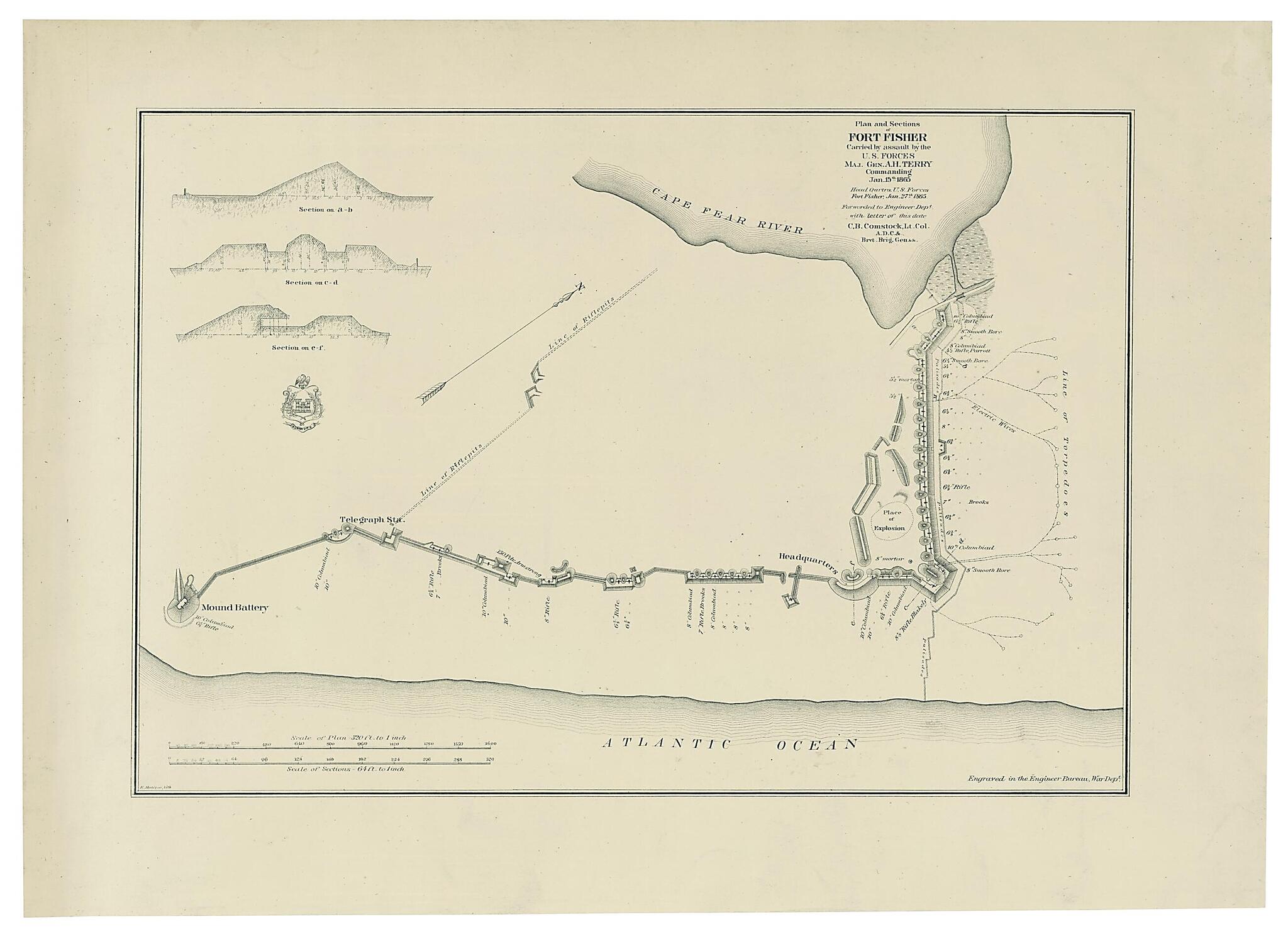
Plan and Sections of Fort Fisher, Carried by Assault by the U.S. Forces, Maj. Gen. A.H. Terry Commanding, Jan. 15th, 1865
- Regular price
-
$54.95 - Regular price
-
$31.95 - Sale price
-
$54.95
Shipping calculated at checkout.
Buy one map, get any other map in our collection for 50% OFF! Add to cart to see discount.
Couldn't load pickup availability
About This Map
Old map of Fort Fisher, North Carolina, United States.
Created by C. B. (Cyrus Ballou) Comstock, E. Molitor, Alfred Howe Terry, United States. War Dept. Engineer Bureau in 1865.
Created by C. B. (Cyrus Ballou) Comstock, E. Molitor, Alfred Howe Terry, United States. War Dept. Engineer Bureau in 1865.
- "Head Qurtrs., U.S. forces, Fort Fisher, Jan. 27th, 1865, forwarded to Engineer Dept. with letter of this date, C.B. Comstock, Lt. Col., A.D.C. & Brvt. Brig. Gen. & &."
- Detailed plan of the fort showing the position, type, and size of guns, riffle pits, and electric wires leading to a "line of torpedoes."
- Includes 3 cross sections; scale 64 ft. to 1 in.
- Relief shown by hachures.
- This item is in the Map Collection of the Library of Virginia; please contact the Library's Archives Research Services department for more information.
- Civil War Map
- C. 1-3 April 2004, Map Cataloging Team.
- Civil War project no.: lva00200.
- Conservation: Etherington Conservation Center, April 2004.
- Digital image available: 14 x 19.25 in.
Map Subjects
Civil War
Fort Fisher
Fort Fisher (N.C.)
History
North Carolina
United States
C. B. (Cyrus Ballou) Comstock
E. Molitor
Alfred Howe Terry
United States. War Dept. Engineer Bureau
1865
Map Sizing Information
- For the best legibility, order your map in the original size or larger. Most maps have intricate detail and small text that is best appreciated when the print size hasn't been reduced.
- Sizes labeled "Fits a Standard Frame" will drop right into any frame that you purchase in that size. The sizes that we offer are commonly available online and at most retail stores.
- Our standard sizes are recommendations based on the aspect ratio of the original map, but still may require some added "white space" in one dimension to fit.
- Non-standard sizes will require custom framing, and we suggest taking your print to the frame shop of your choice after you receive it for the best results.
- Custom sizes are available, simply contact us for a quote.
Below is an approximation of the scale of a few standard sizes, and how they might appear in your space.

