
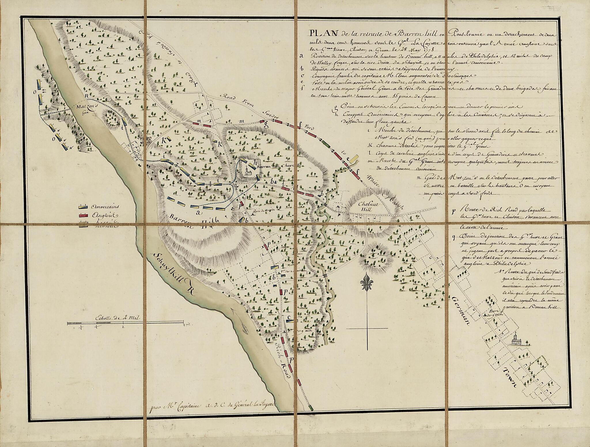
Plan De La Retraite De Barren Hill En Pensilvanie : Ou Un Détachement De Deux Mille Deux Cent Hommes Sous Le G'al LaFayette étois Entouré Par L'Armée Angloise Sous Les G'als Howe, Clinton Et Grant Le 28 May 1778 (Plan De La Retraite De Barren Hill...
- Regular price
-
$54.95 - Regular price
-
$33.95 - Sale price
-
$54.95
Shipping calculated at checkout.
Buy one map, get any other map in our collection for 50% OFF! Add to cart to see discount.
Couldn't load pickup availability
About This Map
Old topographic map / manuscript map of Barren Hill Region, Chestnut Hill, Germantown, Pennsylvania, Philadelphia, United States.
Created by Michel Capitaine Du Chesnoy, Marie Joseph Paul Yves Roch Gilbert Du Motier Lafayette in 1778.
Created by Michel Capitaine Du Chesnoy, Marie Joseph Paul Yves Roch Gilbert Du Motier Lafayette in 1778.
- Covers Barren Hill and vicinity (Whitemarsh Twp., Montgomery Co., Pa.) with Chestnut Hill and Germantown.
- Relief shown by hachures.
- Place-names in English.
- Pen-and-ink, watercolors, wash, and lead pencil.
- Sectioned to 8 panels and mounted on cloth backing to fold to ca. 20 x 14 cm.
- Includes descriptive index of American, English, and Hessian military positions.
- Gift; Mr. and Mrs. H.F. Lenfest; Jan. 2000.
Map Subjects
Barren Hill Region
Barren Hill Region (Pa.)
Chestnut Hill
Chestnut Hill (Philadelphia Pa.)
Defenses
Early Works To 1800
Germantown
Germantown (Philadelphia Pa.)
History
Manuscript Maps
Pennsylvania
Philadelphia
Revolution
Topographic Maps
United States
Michel Capitaine Du Chesnoy
Marie Joseph Paul Yves Roch Gilbert Du Motier Lafayette
1778
Map Sizing Information
- For the best legibility, order your map in the original size or larger. Most maps have intricate detail and small text that is best appreciated when the print size hasn't been reduced.
- Sizes labeled "Fits a Standard Frame" will drop right into any frame that you purchase in that size. The sizes that we offer are commonly available online and at most retail stores.
- Our standard sizes are recommendations based on the aspect ratio of the original map, but still may require some added "white space" in one dimension to fit.
- Non-standard sizes will require custom framing, and we suggest taking your print to the frame shop of your choice after you receive it for the best results.
- Custom sizes are available, simply contact us for a quote.
Below is an approximation of the scale of a few standard sizes, and how they might appear in your space.

