
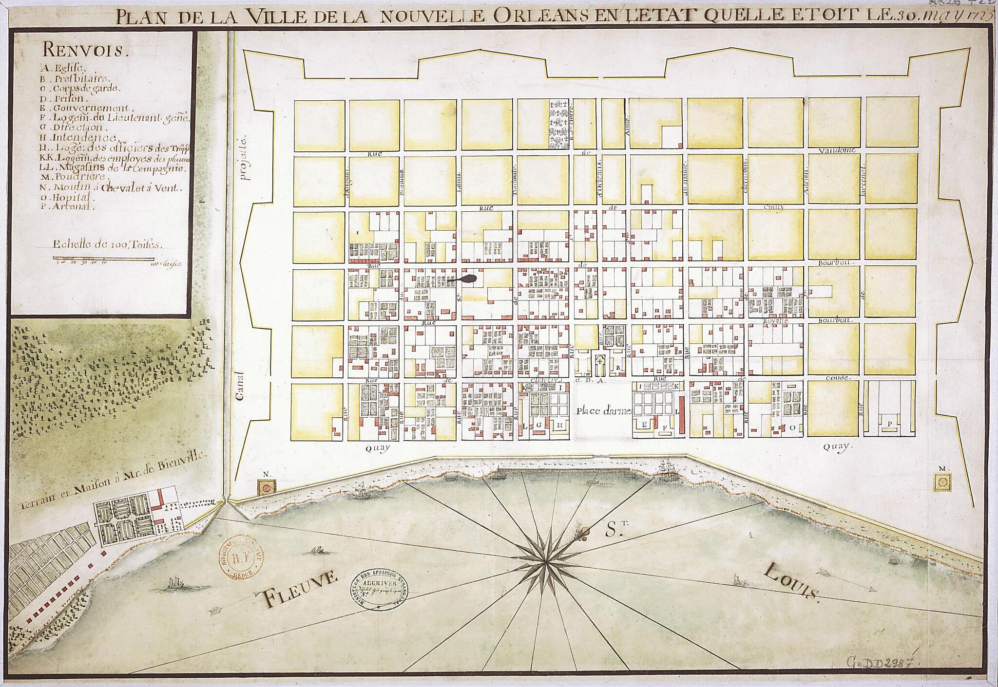
Map of the City of New Orleans As It Was On May 30, 1725. (Plan De La Ville De La Nouvelle Orléans En L'état Quelle étoit Le 30 May 1725)
- Regular price
-
$49.95 - Regular price
-
$34.95 - Sale price
-
$49.95
Buy one map, get any other map in our collection for 50% OFF! Add to cart to see discount.
Couldn't load pickup availability
About This Map
Discover the timeless beauty of our fine art quality printed reproduction of this antique map. Perfect for history enthusiasts, collectors, and interior decorators.
Restored with meticulous attention to detail by our team with over a decade of experience, this stunning reproduction captures the intricate artistry and historical significance of the original map.
Whether you're a collector or seeking a unique decor piece, this archival-quality map reproduction is a timeless addition to any space. Order now to bring history to life!
Old map of Louisiana, New Orleans, United States of America.Baptiste Le Moyne de Bienville and named in honor of the regent of France, Philippe d'Orléans (1674--1723), who awarded the monopoly to exploit the adjacent colony to John Law and the Compagnie d'Occident (Company of the West). Located on the Mississippi River, near where it flows into the Gulf of Mexico, the town became the capital of Louisiana in 1722. This map by an unknown cartographer shows how it appeared in 1725. Built on a uniform, rectangular grid system, the town was protected by a narrow retaining wall and had a place d'armes (public square) that opened onto the river. Many of the buildings were for colonial administration (such as government offices, the intendancy, the prison, and military barracks) and religious functions (church, presbytery, and hospital), but the town also included many company buildings, as indicated in the legend. In the lower left, just outside the town wall, the house and property belonging to the Sieur de Bienville, who was several times governor of Louisiana, are shown. Scale on the map is given in toises; one toise equals about 1.95 meters. The map has a compass rose and drawings of ships and boats in the harbor. It is from the collection of the geographer Jean-Baptiste Bourguignon d'Anville (1697--1782). It was given to King Louis XVI in 1782 and deposited in the National Library of France in 1924.
- Title devised, in English, by Library staff.
- Original resource extent: 1 map : manuscript ; 44.5 x 64 centimeters.
- Original resource at: National Library of France.
- Content in French.
- Description based on data extracted from World Digital Library, which may be extracted from partner institutions.
Map Subjects
05-30
Cities And Towns
Colonies
France
France In America
Louisiana
Manuscript Maps
Mississippi River
New France
New Orleans
United States Of America
1725
- For the best legibility, order your map in the original size or larger. Most maps have intricate detail and small text that is best appreciated when the print size hasn't been reduced.
- Sizes labeled "Fits a Standard Frame" will drop right into any frame that you purchase in that size. The sizes that we offer are commonly available online and at most retail stores.
- Our standard sizes are recommendations based on the aspect ratio of the original map, but still may require some added "white space" in one dimension to fit.
- Non-standard sizes will require custom framing, and we suggest taking your print to the frame shop of your choice after you receive it for the best results.
- Custom sizes are available, simply contact us for a quote.
Below is an approximation of the scale of a few standard sizes, and how they might appear in your space.
