
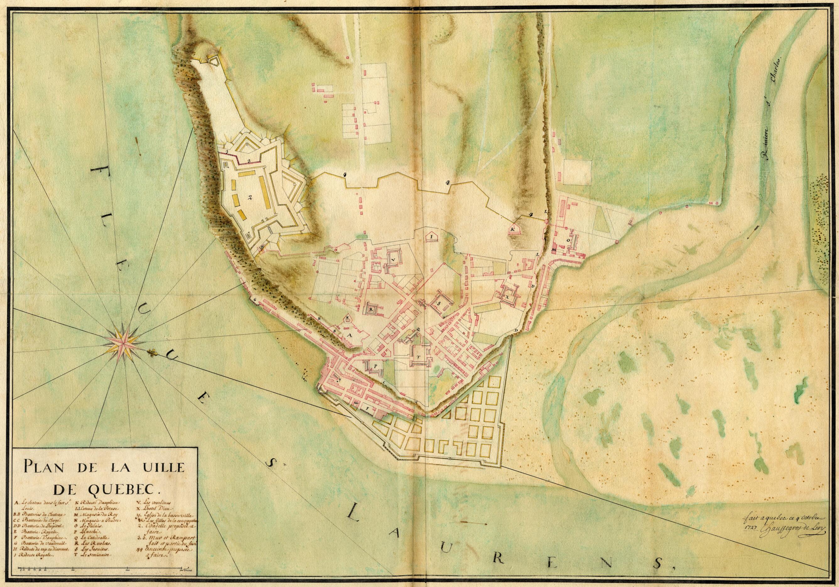
Map of Quebec City. (Plan De La Ville De Québec) 1727
- Regular price
-
$84.95 - Regular price
-
$79.95 - Sale price
-
$84.95
Buy one map, get any other map in our collection for 50% OFF! Add to cart to see discount.
Couldn't load pickup availability
About This Map
Discover the timeless beauty of our fine art quality printed reproduction of this antique map. Perfect for history enthusiasts, collectors, and interior decorators.
Restored with meticulous attention to detail by our team with over a decade of experience, this stunning reproduction captures the intricate artistry and historical significance of the original map.
Whether you're a collector or seeking a unique decor piece, this archival-quality map reproduction is a timeless addition to any space. Order now to bring history to life!
Old map of Canada, Quebec, Québec.drawn map created in 1727, which shows the Upper Town of Quebec City within and outside the city walls, and the Lower Town, near the confluence of the Saint Lawrence River and the Saint Charles River with its tidal flats. A compass wind rose is situated in the Saint Lawrence, on the left side of the map, and the map is oriented with north to the right. It was drawn by Gaspard-Joseph Chaussegros de Léry (1682--1756), who, as the king's chief engineer, had been commissioned to develop the city and build fortifications around it. The map shows a future citadel and a new wall to the west, as well as plans for expansion of the Lower Town. The legend identifies by letters and numbers existing structures and those the engineer proposed, such as the castle and Saint-Louis Fort, as well as the Royale, Dauphine, and Vaudreuil artillery batteries. The map also shows the Royale, Dauphine, and Cap Diamant redoubts, the potash hill (present-day Côte de la Potasse), the king's warehouses, the gunpowder warehouses, the quartermaster's palace, the bishop's palace, Notre-Dame Cathedral, the Recollects' church, the Jesuit church and school, the seminary, the Ursuline monastery, and the Hotel-Dieu (hospital) with the Augustinian Monastery. Also marked are the church in Lower Town (Notre-Dame-des-Victoires), and "filles de la congrégation" (an establishment that housed young French immigrant girls until they married), the proposed citadel, the existing wall and fortification of the citadel, as well as the proposed new wall. The existing and future building works are drawn using distinct colors, red for the former, and yellow for the latter. Originally established in 1608 by the French explorer Samuel de Champlain on the same site as a fort built by Jacques Cartier in 1535, Quebec City became the capital of New France. It is one of the oldest cities in Canada and, indeed, within all of North America. It is the only North American city to have retained all of its fortifications, including its outer wall. Scale is indicated in toises, an old French unit measuring about 1.95 meters.
Created by Joseph in 1727.
- Title devised, in English, by Library staff.
- Original resource extent: 1 map : color.
- Original resource at: National Library and Archives of Quebec.
- Content in French.
- Description based on data extracted from World Digital Library, which may be extracted from partner institutions.
- For the best legibility, order your map in the original size or larger. Most maps have intricate detail and small text that is best appreciated when the print size hasn't been reduced.
- Sizes labeled "Fits a Standard Frame" will drop right into any frame that you purchase in that size. The sizes that we offer are commonly available online and at most retail stores.
- Our standard sizes are recommendations based on the aspect ratio of the original map, but still may require some added "white space" in one dimension to fit.
- Non-standard sizes will require custom framing, and we suggest taking your print to the frame shop of your choice after you receive it for the best results.
- Custom sizes are available, simply contact us for a quote.
Below is an approximation of the scale of a few standard sizes, and how they might appear in your space.

