
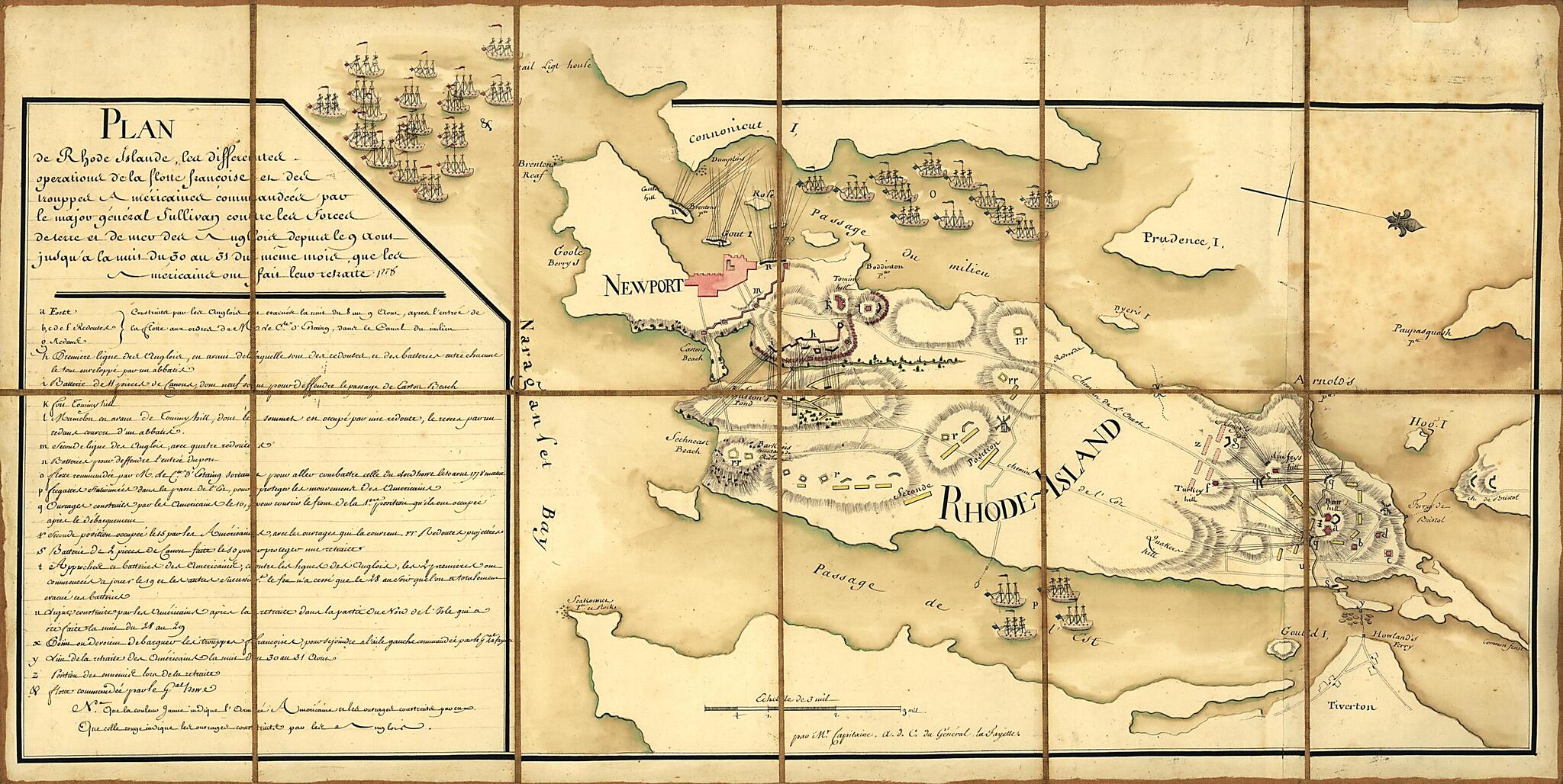
Plan De Rhode Islande, Les Differentes Operations De La Flotte Françoise Et Des Trouppes Américaines Commandeés Par Le Major Général Sullivan Contre Les Forces De Terre Et De Mer Des Anglois Depuis Le 9 Aout Jusqu'a La Nuit Du 30 Au 31 Du Même M...
- Regular price
-
$57.95 - Regular price
-
$52.95 - Sale price
-
$57.95
Shipping calculated at checkout.
Buy one map, get any other map in our collection for 50% OFF! Add to cart to see discount.
Couldn't load pickup availability
About This Map
Old map of Island, Newport Region, Rhode Island, Rhode Island (Island), United States.
Created by Michel Capitaine Du Chesnoy, Marie Joseph Paul Yves Roch Gilbert Du Motier Lafayette in 1778.
Created by Michel Capitaine Du Chesnoy, Marie Joseph Paul Yves Roch Gilbert Du Motier Lafayette in 1778.
- Relief shown by hachures.
- Some place names in English.
- Oriented with north toward the lower right.
- Pen-and-ink and watercolor.
- Sectioned and mounted on cloth backing.
- Includes descriptive index to defenses.
- On label affixed to verso of backing: No. 131. Plan de L'affaire de Rhode islande en Aoust 1778.
- Gift; Mr. and Mrs. H.F. Lenfest; Jan. 2000
Map Subjects
Defenses
Early Works To 1800
Maps Manuscript
Newport Region
Newport Region (R.I.)
Rhode Island
Rhode Island (Island)
Rhode Island (R.I. : Island)
Rhode Island Battle Of R.I.
United States
Island
Michel Capitaine Du Chesnoy
Marie Joseph Paul Yves Roch Gilbert Du Motier Lafayette
1778
Map Sizing Information
- For the best legibility, order your map in the original size or larger. Most maps have intricate detail and small text that is best appreciated when the print size hasn't been reduced.
- Sizes labeled "Fits a Standard Frame" will drop right into any frame that you purchase in that size. The sizes that we offer are commonly available online and at most retail stores.
- Our standard sizes are recommendations based on the aspect ratio of the original map, but still may require some added "white space" in one dimension to fit.
- Non-standard sizes will require custom framing, and we suggest taking your print to the frame shop of your choice after you receive it for the best results.
- Custom sizes are available, simply contact us for a quote.
Below is an approximation of the scale of a few standard sizes, and how they might appear in your space.
