
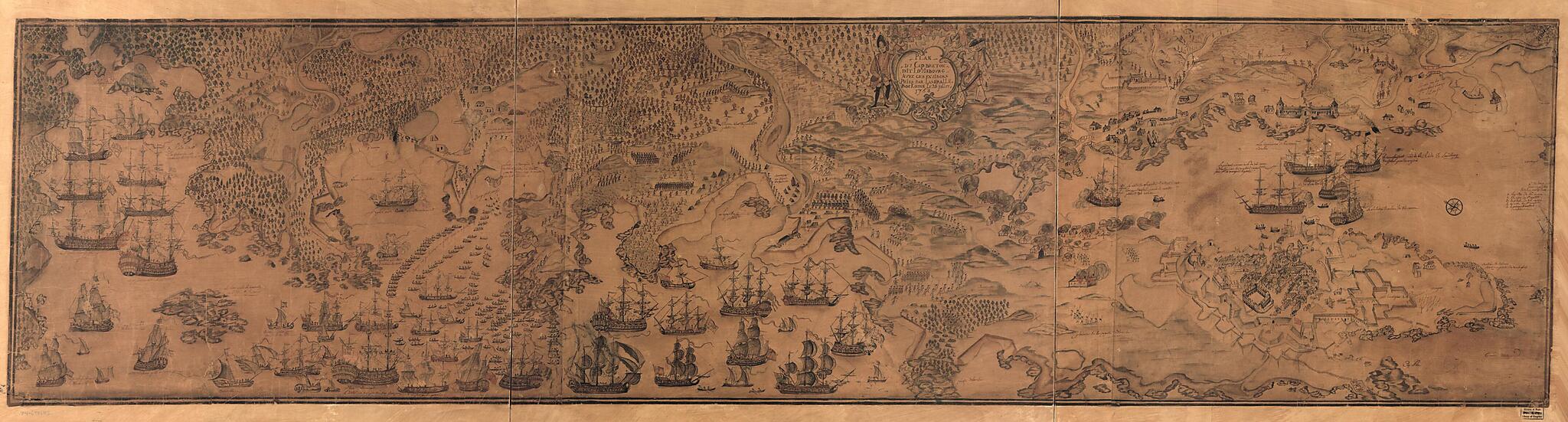
Plan Du Cap Breton, Dit Louisbovrg Avec Ces Environs Pries (Plan Du Cap Breton, Dit Louisbourg Avec Ces Environs Pries) 1758
- Regular price
-
$164.95 - Regular price
-
$159.95 - Sale price
-
$164.95
Shipping calculated at checkout.
Buy one map, get any other map in our collection for 50% OFF! Add to cart to see discount.
Couldn't load pickup availability
About This Map
Old map of Canada, Fortress of Louisbourg National Historic Site, Louisbourg, Louisbourg Region, Nova Scotia.
Created by Lamiralle Bockoune in 1758.
Created by Lamiralle Bockoune in 1758.
- Relief shown by shading and land forms.
- Buildings, vegetation, ships and military troop and encampent positions shown pictorially.
- Shows military troop and ship positions for the Siege of Louibourg in 1758.
- Manuscript, pen-and-ink, pencil, and watercolor, covered with silk fabric and varnished.
- Oriented with north toward the upper left.
Map Subjects
Canada
Early Works To 1800
Fortress Of Louisbourg National Historic Site (N.S.)
History
Louisbourg
Louisbourg (N.S.)
Louisbourg Region (N.S.)
Maps Manuscript
Nova Scotia
Siege
Fortress Of Louisbourg National Historic Site
Louisbourg Region
Lamiralle Bockoune
1758
Map Sizing Information
- For the best legibility, order your map in the original size or larger. Most maps have intricate detail and small text that is best appreciated when the print size hasn't been reduced.
- Sizes labeled "Fits a Standard Frame" will drop right into any frame that you purchase in that size. The sizes that we offer are commonly available online and at most retail stores.
- Our standard sizes are recommendations based on the aspect ratio of the original map, but still may require some added "white space" in one dimension to fit.
- Non-standard sizes will require custom framing, and we suggest taking your print to the frame shop of your choice after you receive it for the best results.
- Custom sizes are available, simply contact us for a quote.
Below is an approximation of the scale of a few standard sizes, and how they might appear in your space.
