
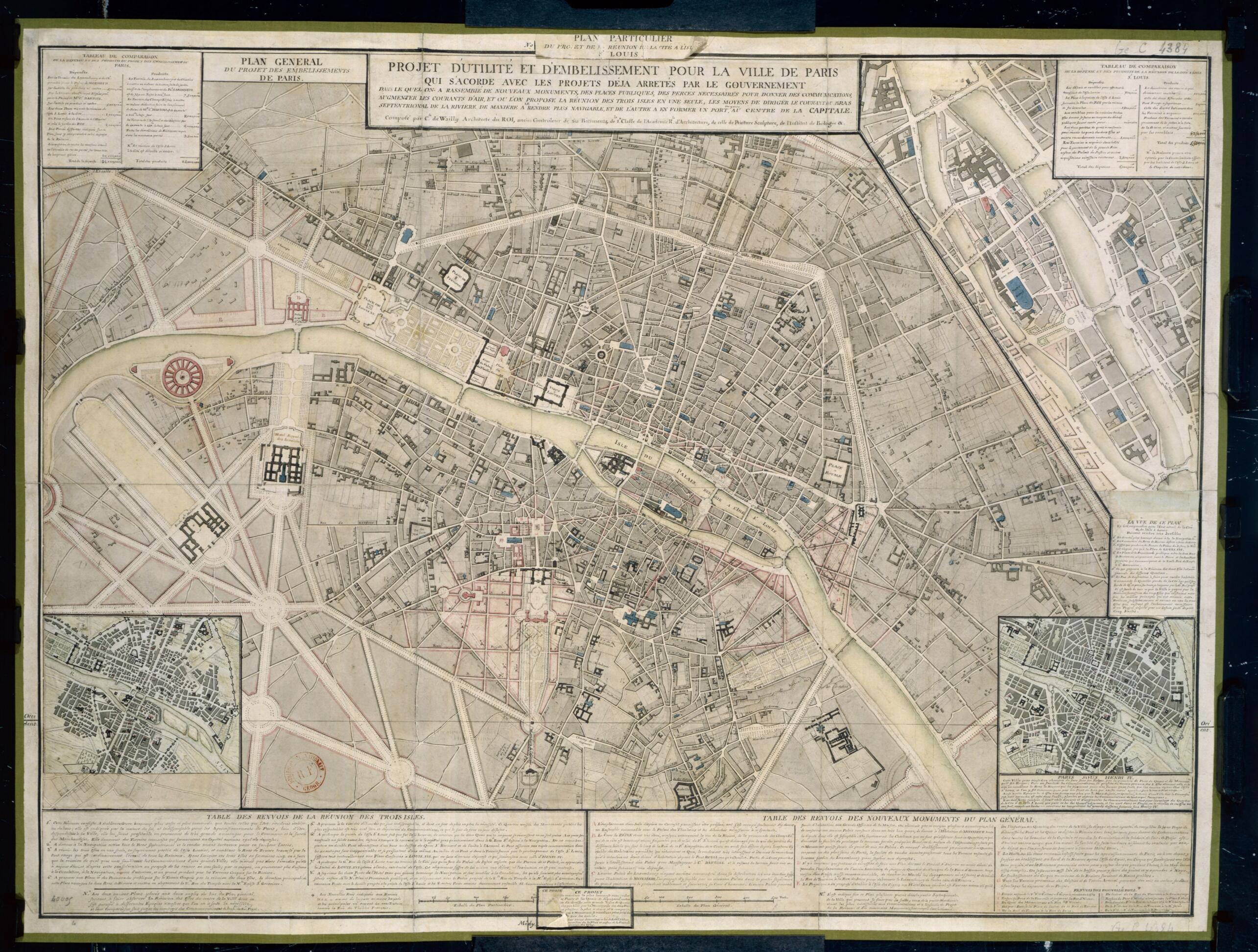
Plan for the Improvement and Beautification of the City of Paris, In Accordance With the Designs Already Outlined by the Government. (Projet D'utilité Et D'embellissement Pour La Ville De Paris Qui S'acorde Avec Les Projets Déjà Arretés Par Le Gou...
- Regular price
-
$49.95 - Regular price
-
$34.95 - Sale price
-
$49.95
Shipping calculated at checkout.
Buy one map, get any other map in our collection for 50% OFF! Add to cart to see discount.
Couldn't load pickup availability
About This Map
Old map of France, Paris, De-France.
98) was a French architect who is known today for the buildings he designed, rather than for his plans for urban redevelopment. The work he carried out as an urban planner was limited to the environs of the Paris Opera and the new Port-Vendres, in Roussillon. De Wailly nevertheless had a great many ideas for urban redevelopment that never advanced beyond the planning stage. He devised at least two general concepts for a renovated Paris. One of these seems to have disappeared; the other, acquired by the National Library of France in 1913, represents the first attempt at a total reorganization of the capital. Breaking with the ideas of previous planners, who had proposed redevelopment of the city by sectors, de Wailly envisioned a profound remaking of the entire Parisian landscape. His plan included laying out large new avenues, constructing public squares, erecting monuments, providing more housing, conjoining the city's islands (Cité, Saint-Louis, and Louviers), and improving the flow of the Seine. De Wailly planned not only to beautify the city, but to maximize the efficiency of urban space.
Created by Charles De Wailly in 1789.
- Title devised, in English, by Library staff.
- Original resource extent: Manuscript map, with color enhancement on an engraved background, 62 x 83 centimeters.
- Original resource at: National Library of France.
- Content in French.
- Description based on data extracted from World Digital Library, which may be extracted from partner institutions.
Map Sizing Information
- For the best legibility, order your map in the original size or larger. Most maps have intricate detail and small text that is best appreciated when the print size hasn't been reduced.
- Sizes labeled "Fits a Standard Frame" will drop right into any frame that you purchase in that size. The sizes that we offer are commonly available online and at most retail stores.
- Our standard sizes are recommendations based on the aspect ratio of the original map, but still may require some added "white space" in one dimension to fit.
- Non-standard sizes will require custom framing, and we suggest taking your print to the frame shop of your choice after you receive it for the best results.
- Custom sizes are available, simply contact us for a quote.
Below is an approximation of the scale of a few standard sizes, and how they might appear in your space.

