
Plan Kharbina I Okrestnosteĭ : V Predi︠e︡lakh Polosy Otchuzhdenīi︠a︡ Kitaĭskoĭ Vostochnoĭ Zheli︠e︡znoĭ Dorogi in 1903
- Regular price
-
$206.95 - Regular price
-
$201.95 - Sale price
-
$206.95
Shipping calculated at checkout.
Buy one map, get any other map in our collection for 50% OFF! Add to cart to see discount.
Couldn't load pickup availability
About This Map
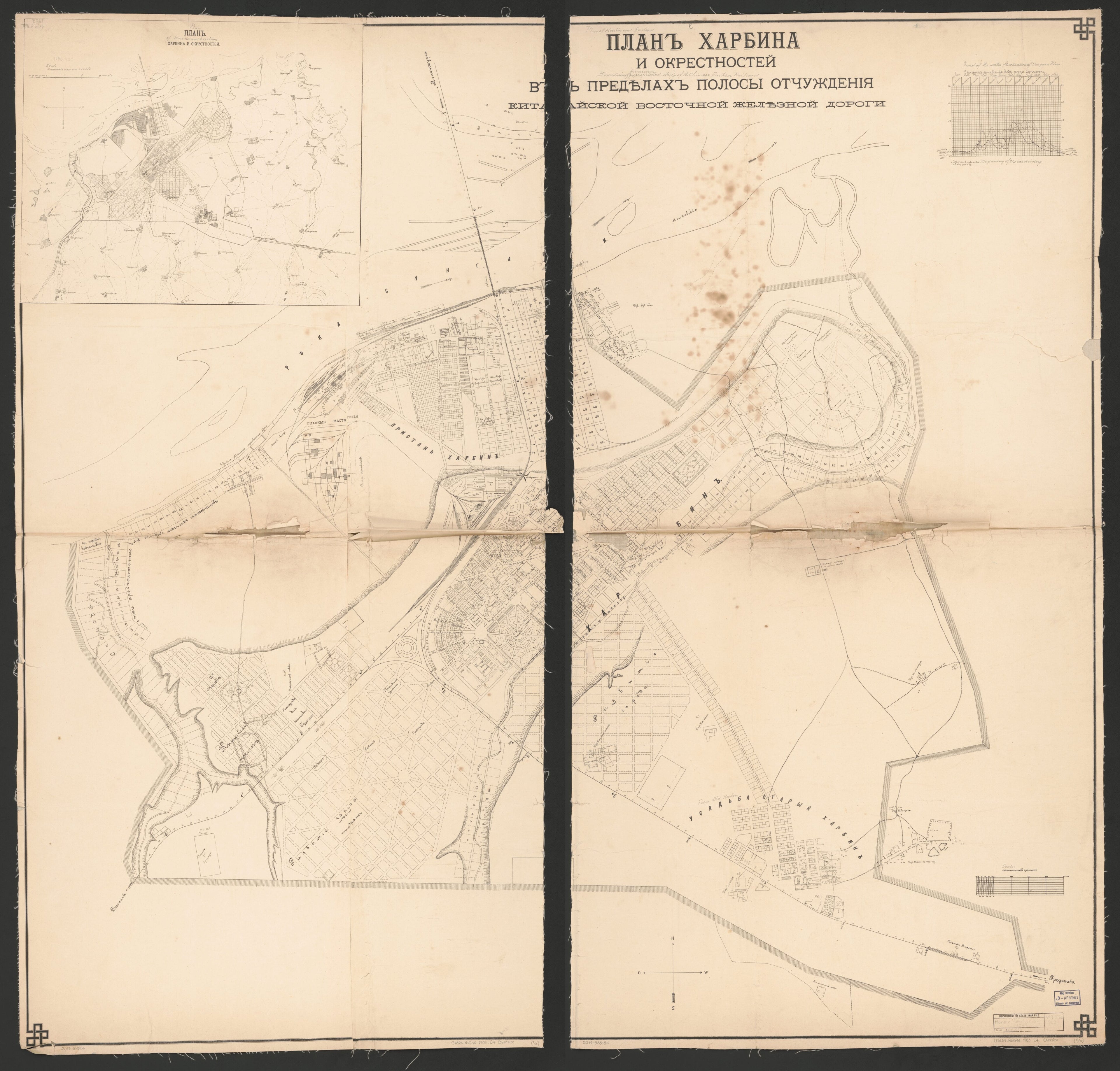
Old cadastral map of China, Harbin, Harbin (Region), Harbin Region.
Created by Chinese Eastern Railway in 1903.
Created by Chinese Eastern Railway in 1903.
- Cadastral wall map of Harbin (Manchuria) showing property lot lines, lot numbers, railroad rights-of-way, city boundary, and planned streets; does not show landowners' names
- Relief shown by hachures
- No dates of information are present on the map
- In Russian
- This map has some imperfections: mounted on cloth backing, fold-lined, torn at fold lines, annotated in lead-pencil on recto to give some english translations, annotated in pencil/ink on verso (cloth backing) "lith no. 215, new chwang, china, december 8, 1903". We'll do our best to restore the image before printing.
- Includes city region inset titled "Plan Kharbina i okrestnosteĭ", graph of Songhua River seasonal water/ice levels, and map scale diagram
Map Sizing Information
- For the best legibility, order your map in the original size or larger. Most maps have intricate detail and small text that is best appreciated when the print size hasn't been reduced.
- Sizes labeled "Fits a Standard Frame" will drop right into any frame that you purchase in that size. The sizes that we offer are commonly available online and at most retail stores.
- Our standard sizes are recommendations based on the aspect ratio of the original map, but still may require some added "white space" in one dimension to fit.
- Non-standard sizes will require custom framing, and we suggest taking your print to the frame shop of your choice after you receive it for the best results.
- Custom sizes are available, simply contact us for a quote.
Below is an approximation of the scale of a few standard sizes, and how they might appear in your space.

