
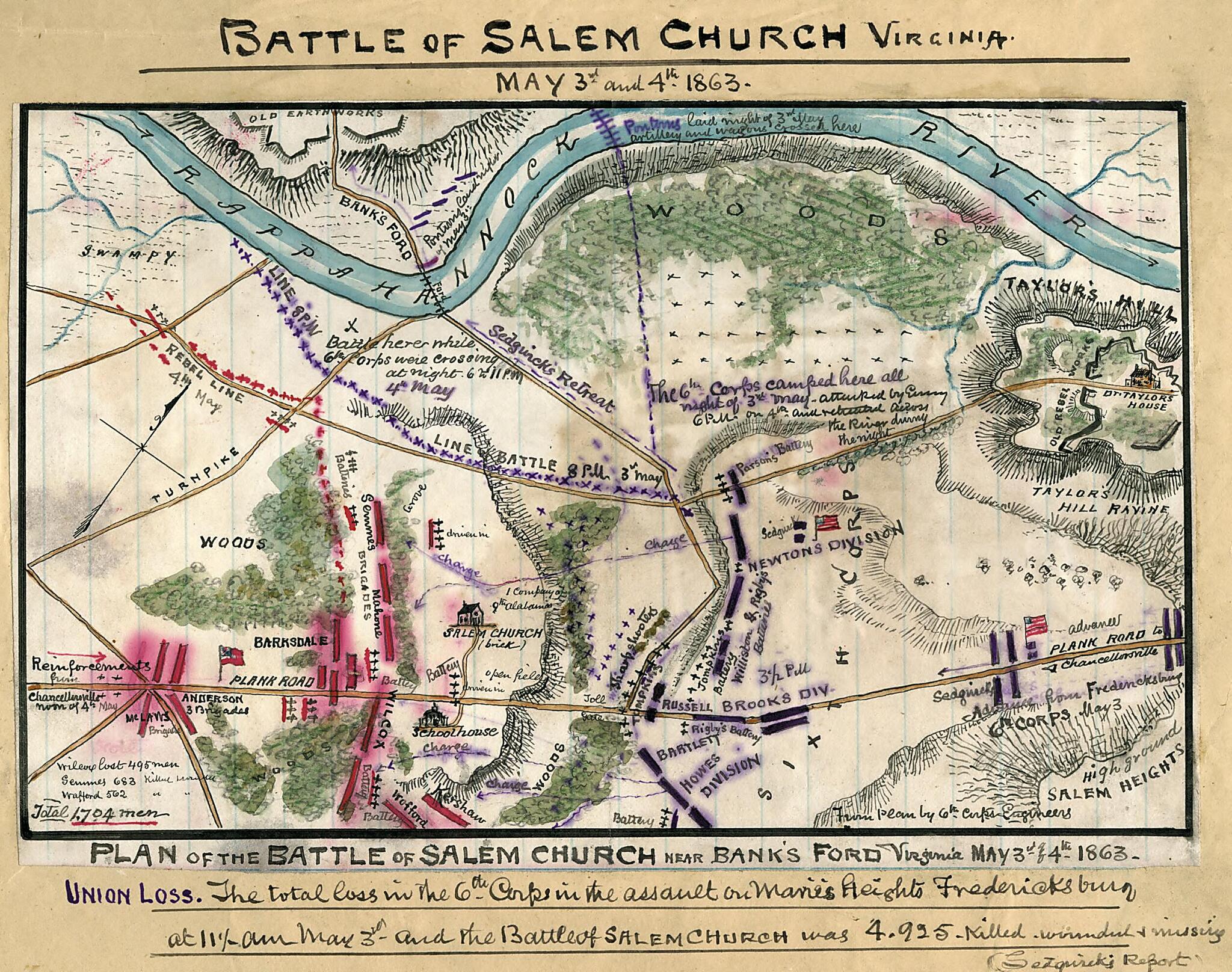
Plan of Battle of Salem Church Near Bank's Ford, Virginia : May 3rd & 4th 1863 05-03
- Regular price
-
$49.95 - Regular price
-
$34.95 - Sale price
-
$49.95
Shipping calculated at checkout.
Buy one map, get any other map in our collection for 50% OFF! Add to cart to see discount.
Couldn't load pickup availability
About This Map
Old map of Chancellorsville, United States, Virginia.
As part of a series depicting the Chancellorsville Campgain, this map gives details of the area around Salem Church, where Union Gen. Sedgwick's forces, en route from Fredericksburg to reinforce Hooker near Chancellorsville, met Confederate opposition under Wilcox. Lee's quick assessment of the potential of the situation led him to redeploy his forces in the hope of destroying Sedgwick's corps. While prevented from joining Hooker, Sedgwick was successful in holding his line and in withdrawing his corps to the northwest, crossing the Rappahannock River near Banks's Ford.
Created by Robert Knox Sneden in 05-03.
- Color coding indicates the location of Union and Confederate forces.
- Relief shown by hachures.
- This item is from the collections of the Virginia Historical Society; please contact the institution for more information.
- Robert Knox Sneden Diary (Mss5:1 Sn237:1), Virginia Historical Society, Richmond, Va.
- In the Robert Knox Sneden Scrapbook (Mss5:7 Sn237:1 p. 252).
- Manuscripts
Map Subjects
Chancellorsville
Chancellorsville Battle Of Chancellorsville VA
Chancellorsville Battle Of Chancellorsville Va.
Salem Church Battle Of VA
Salem Church Battle Of Va.
United States
Virginia
Robert Knox Sneden
05-03
Map Sizing Information
- For the best legibility, order your map in the original size or larger. Most maps have intricate detail and small text that is best appreciated when the print size hasn't been reduced.
- Sizes labeled "Fits a Standard Frame" will drop right into any frame that you purchase in that size. The sizes that we offer are commonly available online and at most retail stores.
- Our standard sizes are recommendations based on the aspect ratio of the original map, but still may require some added "white space" in one dimension to fit.
- Non-standard sizes will require custom framing, and we suggest taking your print to the frame shop of your choice after you receive it for the best results.
- Custom sizes are available, simply contact us for a quote.
Below is an approximation of the scale of a few standard sizes, and how they might appear in your space.

