
Plan of Battles of Kelly's Ford and Rappahannock Station, Virginia : Both Fought Novr. 7th, 1863 11-07
- Regular price
-
$49.95 - Regular price
-
$29.95 - Sale price
-
$49.95
Shipping calculated at checkout.
Buy one map, get any other map in our collection for 50% OFF! Add to cart to see discount.
Couldn't load pickup availability
About This Map
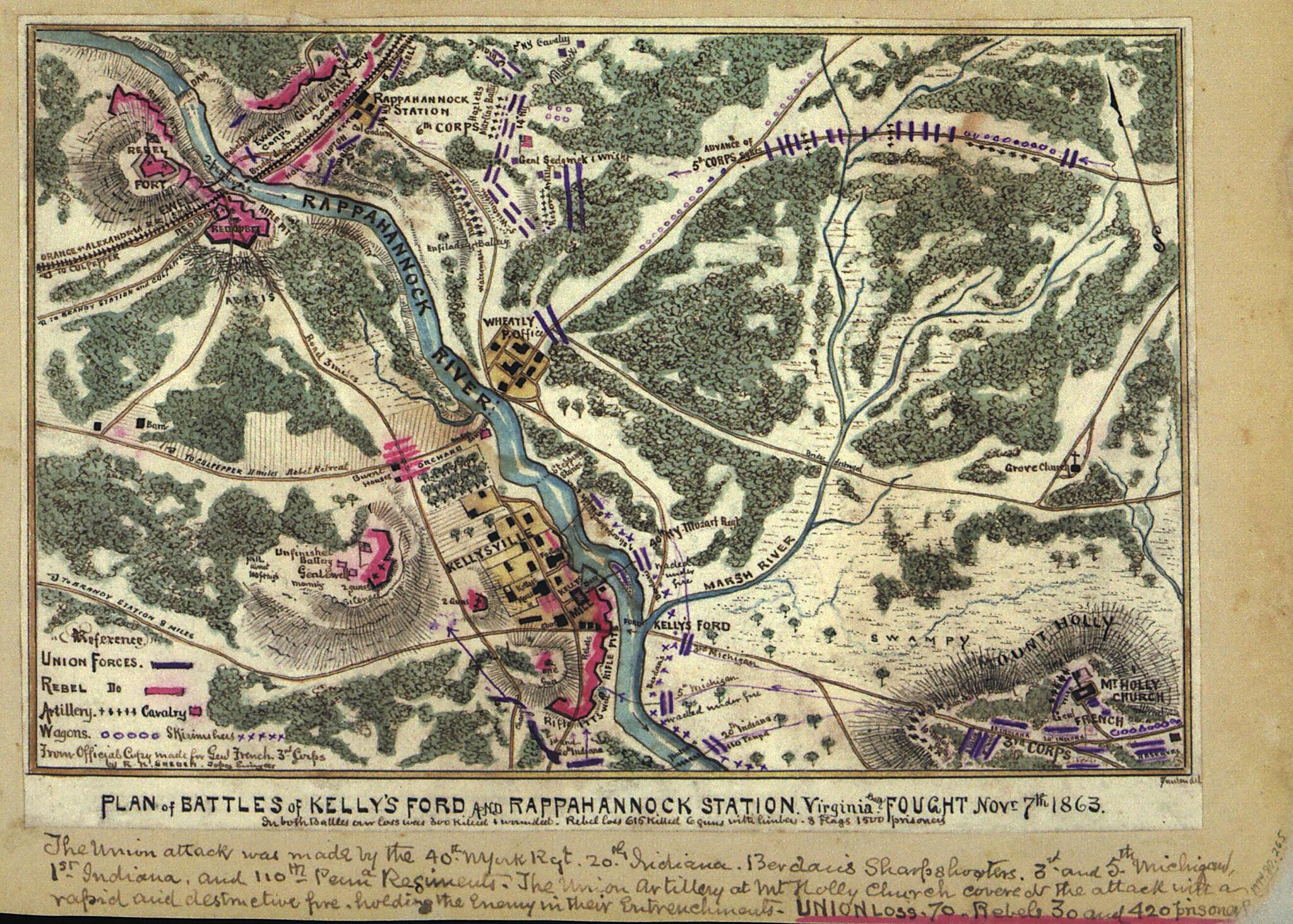
Old map of Culpeper County, Fauquier County, United States, Virginia.
The map shows the area surrounding the Rappahannock River as it runs from north to south; the Orange & Alexandria Railroad is also indicated. The battles of Rappahannock Bridge and Kelly's Ford were part of the Bristoe Campaign.
Created by Robert Knox Sneden in 11-07.
The map shows the area surrounding the Rappahannock River as it runs from north to south; the Orange & Alexandria Railroad is also indicated. The battles of Rappahannock Bridge and Kelly's Ford were part of the Bristoe Campaign.
Created by Robert Knox Sneden in 11-07.
- "The Union attack was made by the 40th N. York Rgt 20th Indiana Berdairs sharpshooters 3rd and 5th Michigan, 1st Indiana, and 110th Penna regiments. The Union artillery at Mt. Holly Church covered the attack with a rapid and destructive fire holding the enemy in their entrenchments. Union loss-70 Rebels-30 and 420 prisoners"--Page caption.
- Color coding indicates the location of Union and Confederate forces.
- Relief shown by hachures.
- This item is from the collections of the Virginia Historical Society; please contact the institution for more information.
- In the Robert Knox Sneden Scrapbook (Mss5:7 Sn237:1 p. 265).
- Manuscripts
Map Subjects
Civil War
Culpeper County
Culpeper County (Va.)
Fauquier County
Fauquier County (Va.)
History
Kelly's Ford Battle Of VA
Kelly's Ford Battle Of Va.
United States
Virginia
Robert Knox Sneden
11-07
Map Sizing Information
- For the best legibility, order your map in the original size or larger. Most maps have intricate detail and small text that is best appreciated when the print size hasn't been reduced.
- Sizes labeled "Fits a Standard Frame" will drop right into any frame that you purchase in that size. The sizes that we offer are commonly available online and at most retail stores.
- Our standard sizes are recommendations based on the aspect ratio of the original map, but still may require some added "white space" in one dimension to fit.
- Non-standard sizes will require custom framing, and we suggest taking your print to the frame shop of your choice after you receive it for the best results.
- Custom sizes are available, simply contact us for a quote.
Below is an approximation of the scale of a few standard sizes, and how they might appear in your space.

