
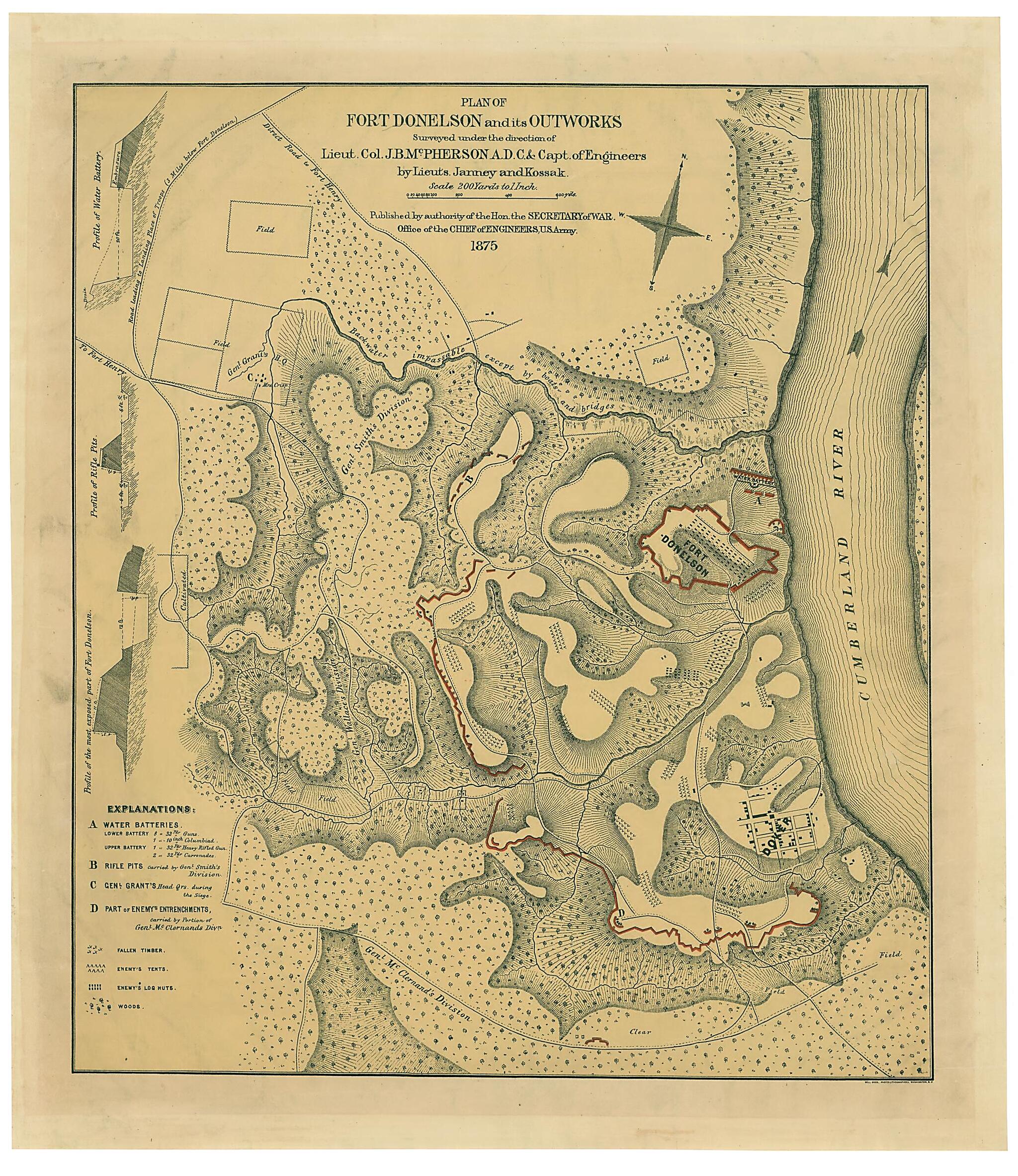
Plan of Fort Donelson and Its Outworks 1875
- Regular price
-
$57.95 - Regular price
-
$52.95 - Sale price
-
$57.95
Shipping calculated at checkout.
Buy one map, get any other map in our collection for 50% OFF! Add to cart to see discount.
Couldn't load pickup availability
About This Map
Old map of Fort Donelson, Tennessee, United States.
Created by Janney, William Kossak, James Birdseye McPherson, United States. Army. Corps of Engineers in 1875.
Created by Janney, William Kossak, James Birdseye McPherson, United States. Army. Corps of Engineers in 1875.
- Description derived from published bibliography.
- Oriented with north toward the upper right.
- Shows topography by hachures, drainage, vegetation, roads, houses, fences, a plan of Dover, fallen timber, "enemy's" tents and log huts, water batteries, entrenchments, Grant's headquarters, and the location of the divisions of General Smith, General Wallace, and General McClernand. A profile of the fort, another profile of the rifle pits, and one of the water battery appear on the left side of the map.
- This item is in the Map Collection of the Library of Virginia; please contact the Library's Archives Research Services department for more information.
- May 1969, source unknown; Oct 2003, Map Cataloging Team.
Map Subjects
Civil War
Fort Donelson
Fort Donelson (Tenn.)
History
Tennessee
United States
Janney
William Kossak
James Birdseye McPherson
United States. Army. Corps Of Engineers
1875
Map Sizing Information
- For the best legibility, order your map in the original size or larger. Most maps have intricate detail and small text that is best appreciated when the print size hasn't been reduced.
- Sizes labeled "Fits a Standard Frame" will drop right into any frame that you purchase in that size. The sizes that we offer are commonly available online and at most retail stores.
- Our standard sizes are recommendations based on the aspect ratio of the original map, but still may require some added "white space" in one dimension to fit.
- Non-standard sizes will require custom framing, and we suggest taking your print to the frame shop of your choice after you receive it for the best results.
- Custom sizes are available, simply contact us for a quote.
Below is an approximation of the scale of a few standard sizes, and how they might appear in your space.

