
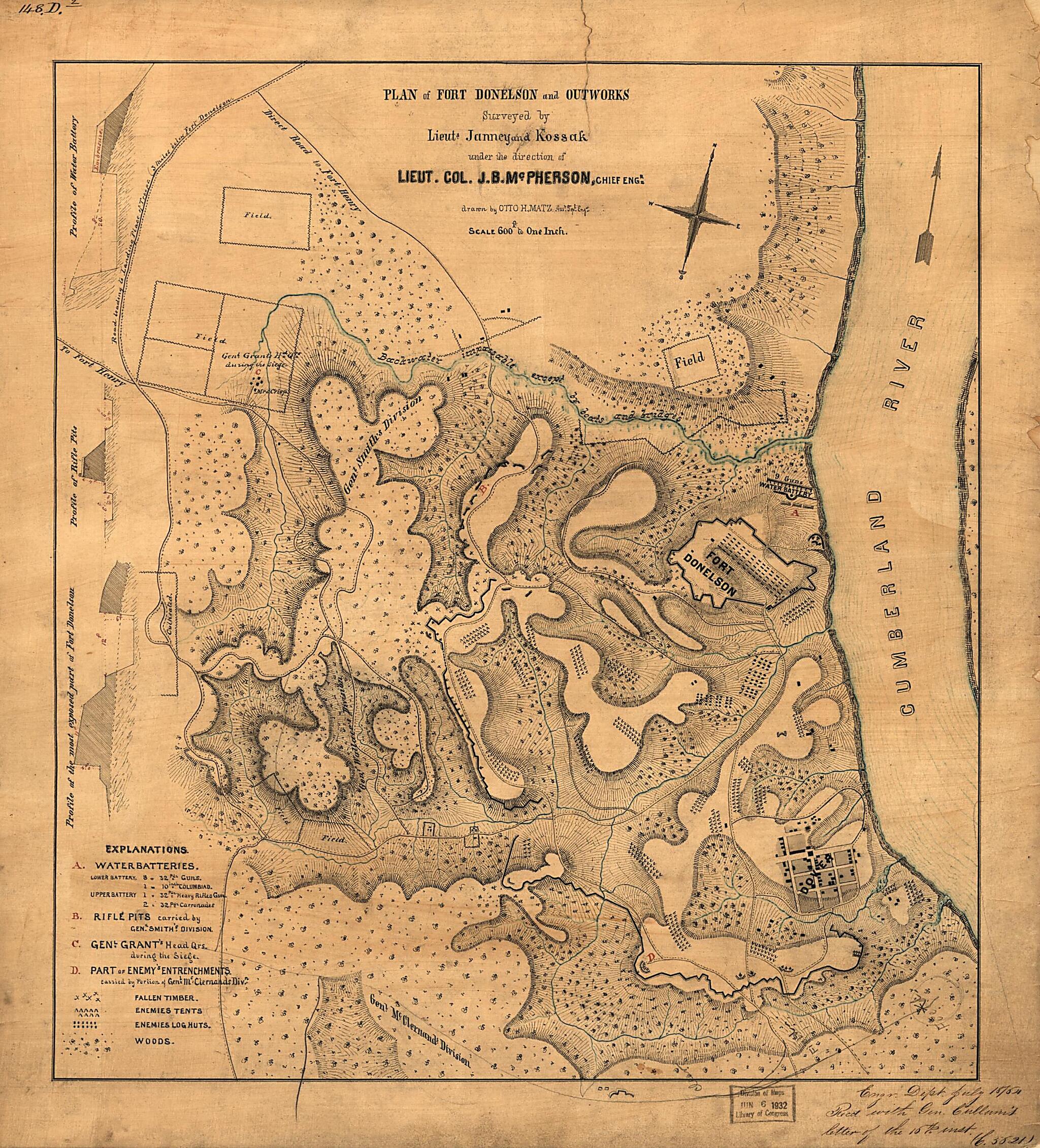
Plan of Fort Donelson and Outworks : Tennessee 1862
- Regular price
-
$62.95 - Regular price
-
$44.95 - Sale price
-
$62.95
Shipping calculated at checkout.
Buy one map, get any other map in our collection for 50% OFF! Add to cart to see discount.
Couldn't load pickup availability
About This Map
Old map of Dover Region, Fort Donelson, Fort Donelson Region, Tennessee, United States.
Created by Janney, William Kossak, Otto H. Matz, James Birdseye McPherson, United States. War Department. Corps of Engineers in 1862.
Created by Janney, William Kossak, Otto H. Matz, James Birdseye McPherson, United States. War Department. Corps of Engineers in 1862.
- Shows the fort, town of Dover, fortifications, "Enemies' tents", "Enemies' log huts", woods, and areas of fallen timber.
- Relief shown by hachures and form lines.
- At lower right in handwriting: Engr. Dept. July 18/64. Recd. with Gen. Cullum's letter of the 16th inst. (C. 5621).
- Pen-and-ink (black/blue/red), blue wash, and lead pencil.
- Mounted on paper and cloth backing under gauze covering.
- This map has some imperfections: missing small sections of margin along right edge. We'll do our best to restore the image before printing.
- Includes index of outworks ("Explanations") and 3 fortification profiles at left border.
- In upper left corner: 148.D.².
- Civil War Map
Map Subjects
Defenses
Dover Region
Dover Region (Tenn.)
Fort Donelson (Tenn.)
Fort Donelson Region
Fort Donelson Region (Tenn.)
Fort Donelson Battle Of Tenn
Maps Manuscript
Tennessee
United States
Fort Donelson
Janney
William Kossak
Otto H. Matz
James Birdseye McPherson
United States. War Department. Corps Of Engineers
1862
Map Sizing Information
- For the best legibility, order your map in the original size or larger. Most maps have intricate detail and small text that is best appreciated when the print size hasn't been reduced.
- Sizes labeled "Fits a Standard Frame" will drop right into any frame that you purchase in that size. The sizes that we offer are commonly available online and at most retail stores.
- Our standard sizes are recommendations based on the aspect ratio of the original map, but still may require some added "white space" in one dimension to fit.
- Non-standard sizes will require custom framing, and we suggest taking your print to the frame shop of your choice after you receive it for the best results.
- Custom sizes are available, simply contact us for a quote.
Below is an approximation of the scale of a few standard sizes, and how they might appear in your space.

