
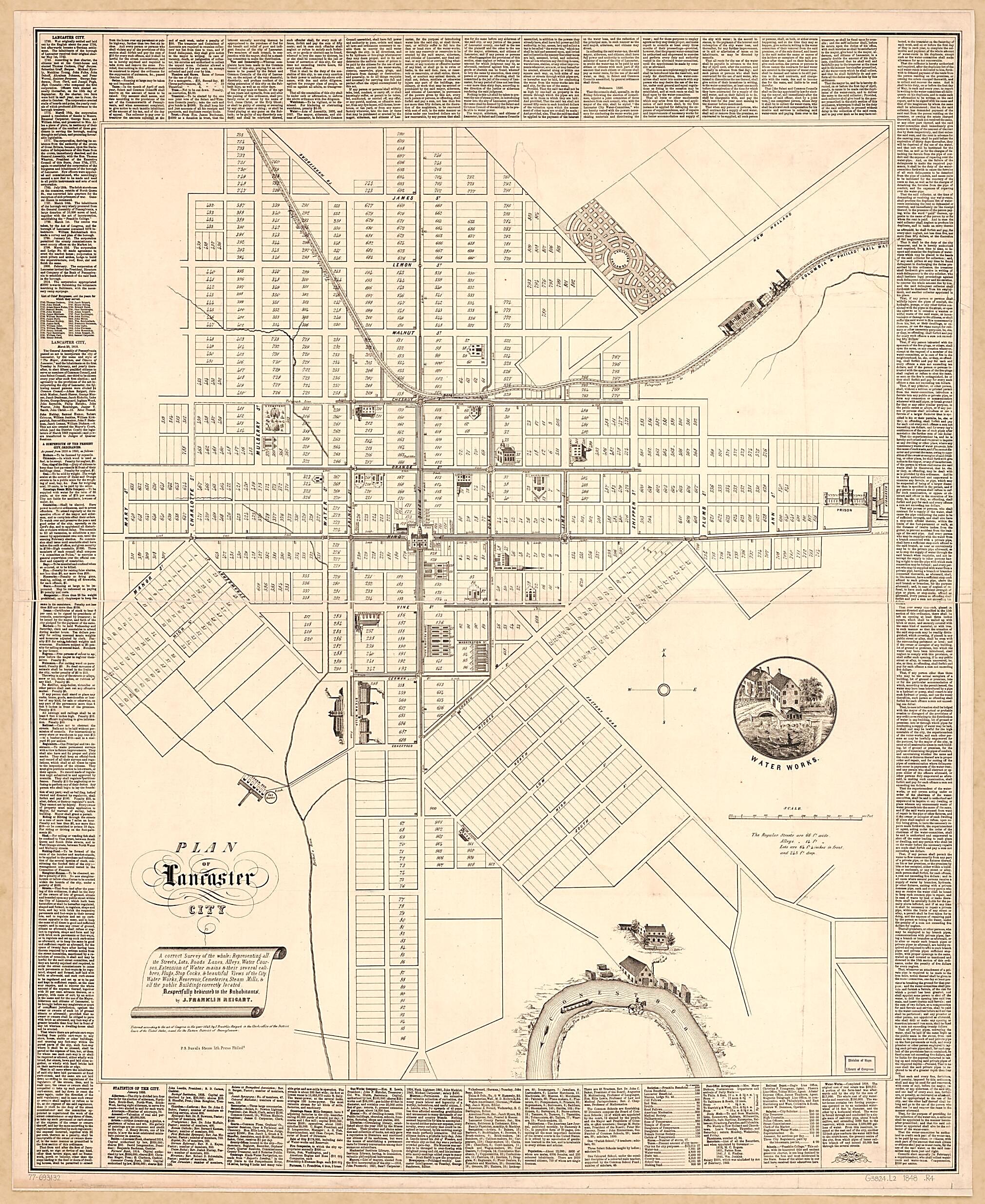
Plan of Lancaster City; a Correct Survey of the Whole; Representing All the Streets, Lots, Roads, Lanes, Alleys, Water Courses, Extension of Water Mains & Their Several Calibres, Plugs, Stop Cocks, & Beautiful Views of the City in 1850
- Regular price
-
$157.95 - Regular price
-
$152.95 - Sale price
-
$157.95
Shipping calculated at checkout.
Buy one map, get any other map in our collection for 50% OFF! Add to cart to see discount.
Couldn't load pickup availability
About This Map
Old map of Lancaster, Pennsylvania, United States.
Created by P.S. Duval & Co, J. Franklin (John Franklin) Reigart in 1850.
Created by P.S. Duval & Co, J. Franklin (John Franklin) Reigart in 1850.
- Scale ca. 1:2,770.
- Relief shown pictorially.
- Cadastral map showing lot numbers.
- "Entered according to the act of Congress in the year 1848, by J. Franklin Reigart, in the clerk's office of the District Court of the United States, in and for the Eastern District of Pennsylvania."
- Prominent buildings shown pictorially.
- Includes text, list of city ordinances, statistical data as of Jan. 1850, and illus.
Map Subjects
Lancaster
Lancaster (Pa.)
Ordinances Municipal
Pennsylvania
Statistics
United States
Supply
P.S. Duval & Co
J. Franklin (John Franklin) Reigart
1850
Map Sizing Information
- For the best legibility, order your map in the original size or larger. Most maps have intricate detail and small text that is best appreciated when the print size hasn't been reduced.
- Sizes labeled "Fits a Standard Frame" will drop right into any frame that you purchase in that size. The sizes that we offer are commonly available online and at most retail stores.
- Our standard sizes are recommendations based on the aspect ratio of the original map, but still may require some added "white space" in one dimension to fit.
- Non-standard sizes will require custom framing, and we suggest taking your print to the frame shop of your choice after you receive it for the best results.
- Custom sizes are available, simply contact us for a quote.
Below is an approximation of the scale of a few standard sizes, and how they might appear in your space.

