
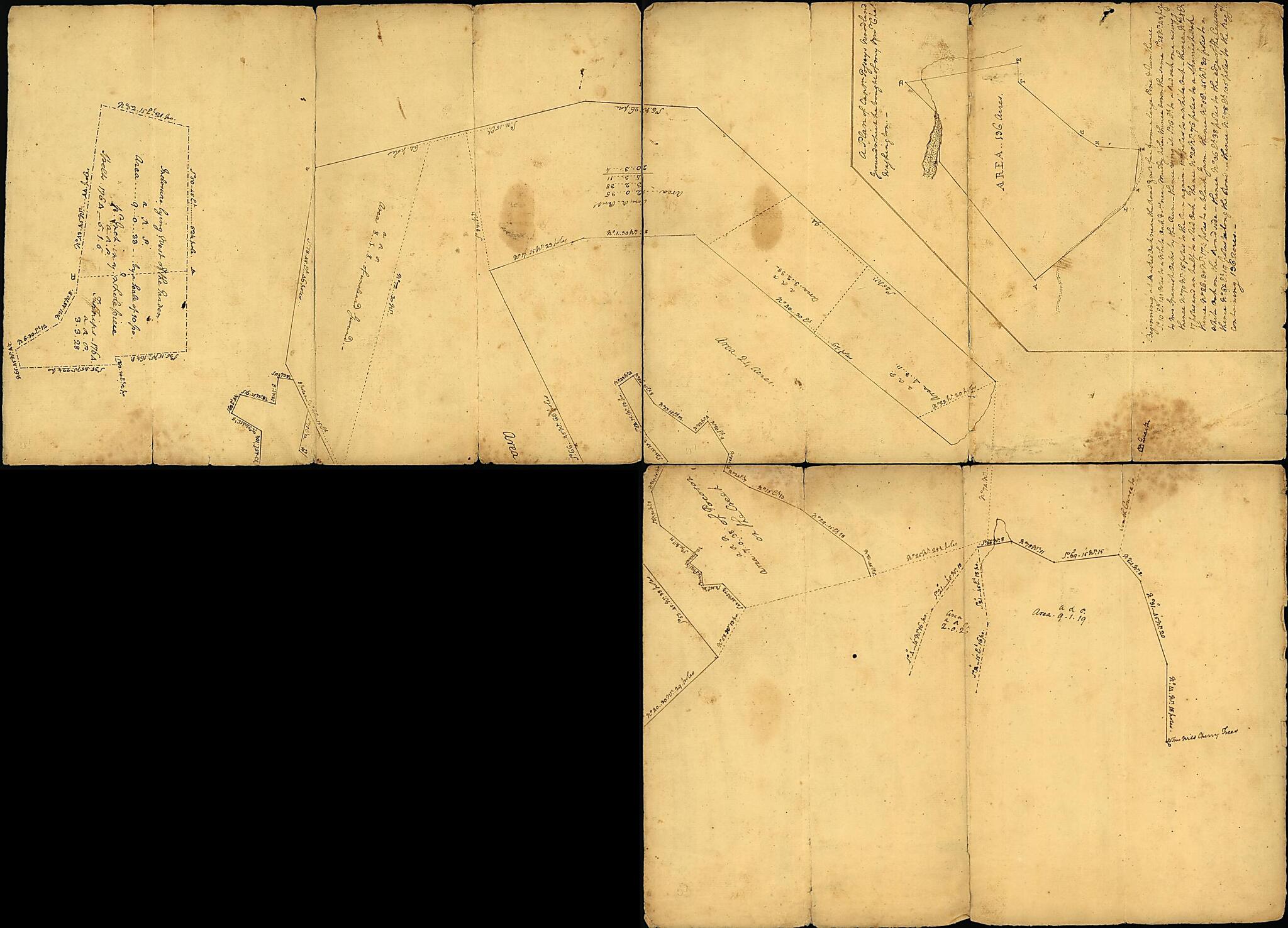
A Plan of Mr. Clifton's Neck Land Platted by a Scale of 50 Poles to the Inch (Plan of Mr. Clifton's Neck Land Platted by a Scale of 50 Poles to the Inch. Old Plat of the Grounds In the NE Part of the Pasture of Mount Vernon from the Summit of the Hill...
- Regular price
-
$74.95 - Regular price
-
$69.95 - Sale price
-
$74.95
Buy one map, get any other map in our collection for 50% OFF! Add to cart to see discount.
Couldn't load pickup availability
About This Map
Discover the timeless beauty of our fine art quality printed reproduction of this antique map. Perfect for history enthusiasts, collectors, and interior decorators.
Restored with meticulous attention to detail by our team with over a decade of experience, this stunning reproduction captures the intricate artistry and historical significance of the original map.
Whether you're a collector or seeking a unique decor piece, this archival-quality map reproduction is a timeless addition to any space. Order now to bring history to life!
Old map of Estate, Mount Vernon, Mount Vernon (Estate), United States, Virginia.Created by George Washington in 1760.
- Title of the pasture map from photocopy of lower right quadrant.
- Sheet stained in several places, folded into sixteenths and separated along some fold lines. Lower right quadrant missing.
- Pen-and-ink.
- Includes watermark, possibly from C. & I. Honig.
- Accompanied by a photocopy of the front side of the missing quadrant, which is owned by the Mount Vernon Ladies' Association of the Union. This section includes an inset of an area surveyed on Nov. 6-8 in 1799.
- Includes 2 insets, list of courses, and list of Mr. Clifton's tenants.
- Insets: A plan of Captn. Posseys's woodland ground which he bought of my bro. Chas. Washington -- Inclosure lying west of the garden.
Map Subjects
Early Works To 1800
Maps Manuscript
Mount Vernon (Estate)
Mount Vernon (Va. : Estate)
Surveys
United States
Virginia
Estate
Mount Vernon
George Washington
1760
- For the best legibility, order your map in the original size or larger. Most maps have intricate detail and small text that is best appreciated when the print size hasn't been reduced.
- Sizes labeled "Fits a Standard Frame" will drop right into any frame that you purchase in that size. The sizes that we offer are commonly available online and at most retail stores.
- Our standard sizes are recommendations based on the aspect ratio of the original map, but still may require some added "white space" in one dimension to fit.
- Non-standard sizes will require custom framing, and we suggest taking your print to the frame shop of your choice after you receive it for the best results.
- Custom sizes are available, simply contact us for a quote.
Below is an approximation of the scale of a few standard sizes, and how they might appear in your space.

