
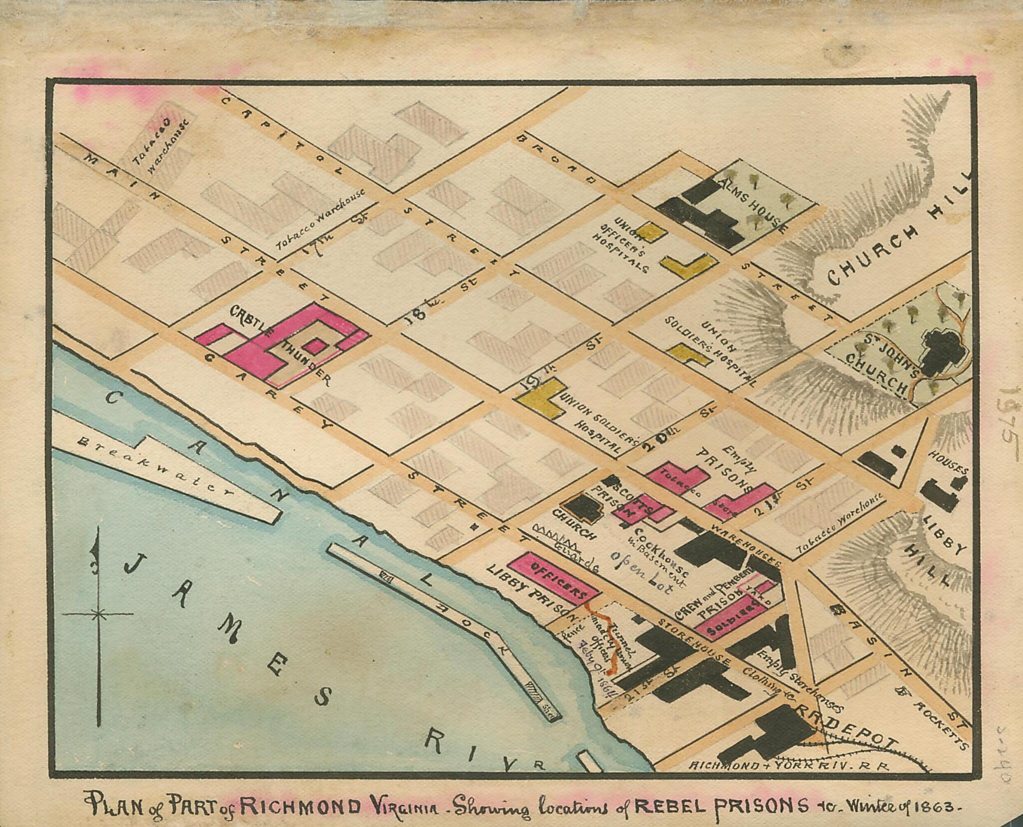
Plan of Part of Richmond, Virginia : Showing Locations of Rebel Prisons in Winter of 1863
- Regular price
-
$49.95 - Regular price
-
$34.95 - Sale price
-
$49.95
Shipping calculated at checkout.
Buy one map, get any other map in our collection for 50% OFF! Add to cart to see discount.
Couldn't load pickup availability
About This Map
Old map of Richmond, United States, Virginia.
Shows the streets of Richmond below Church Hill from the Canal to Broad Street and from 17th to 21st streets, including Castle Thunder and Libby prisons and the Union officers' and soldiers' hospitals.
Created by Robert Knox Sneden in 1863.
Shows the streets of Richmond below Church Hill from the Canal to Broad Street and from 17th to 21st streets, including Castle Thunder and Libby prisons and the Union officers' and soldiers' hospitals.
Created by Robert Knox Sneden in 1863.
- Sneden shows a tunnel made by Union officers starting from Libby Prison and headed for a storehouse at the end of the next block.
- This item is from the collections of the Virginia Historical Society; please contact the institution for more information.
- Robert Knox Sneden scrapbook (Mss5:7 Sn237:1), Virginia Historical Society.
- In the Robert Knox Sneden diary, 1861-1865 (v. 5, p. 240).
Map Subjects
Castle Thunder Prison (Richmond Va.)
Civil War
History
Hospitals
Libby Prison
Military Hospitals
Military Prisons
Prisoners And Prisons
Richmond
Richmond (Va.)
United States
Virginia
Robert Knox Sneden
1863
Map Sizing Information
- For the best legibility, order your map in the original size or larger. Most maps have intricate detail and small text that is best appreciated when the print size hasn't been reduced.
- Sizes labeled "Fits a Standard Frame" will drop right into any frame that you purchase in that size. The sizes that we offer are commonly available online and at most retail stores.
- Our standard sizes are recommendations based on the aspect ratio of the original map, but still may require some added "white space" in one dimension to fit.
- Non-standard sizes will require custom framing, and we suggest taking your print to the frame shop of your choice after you receive it for the best results.
- Custom sizes are available, simply contact us for a quote.
Below is an approximation of the scale of a few standard sizes, and how they might appear in your space.

