
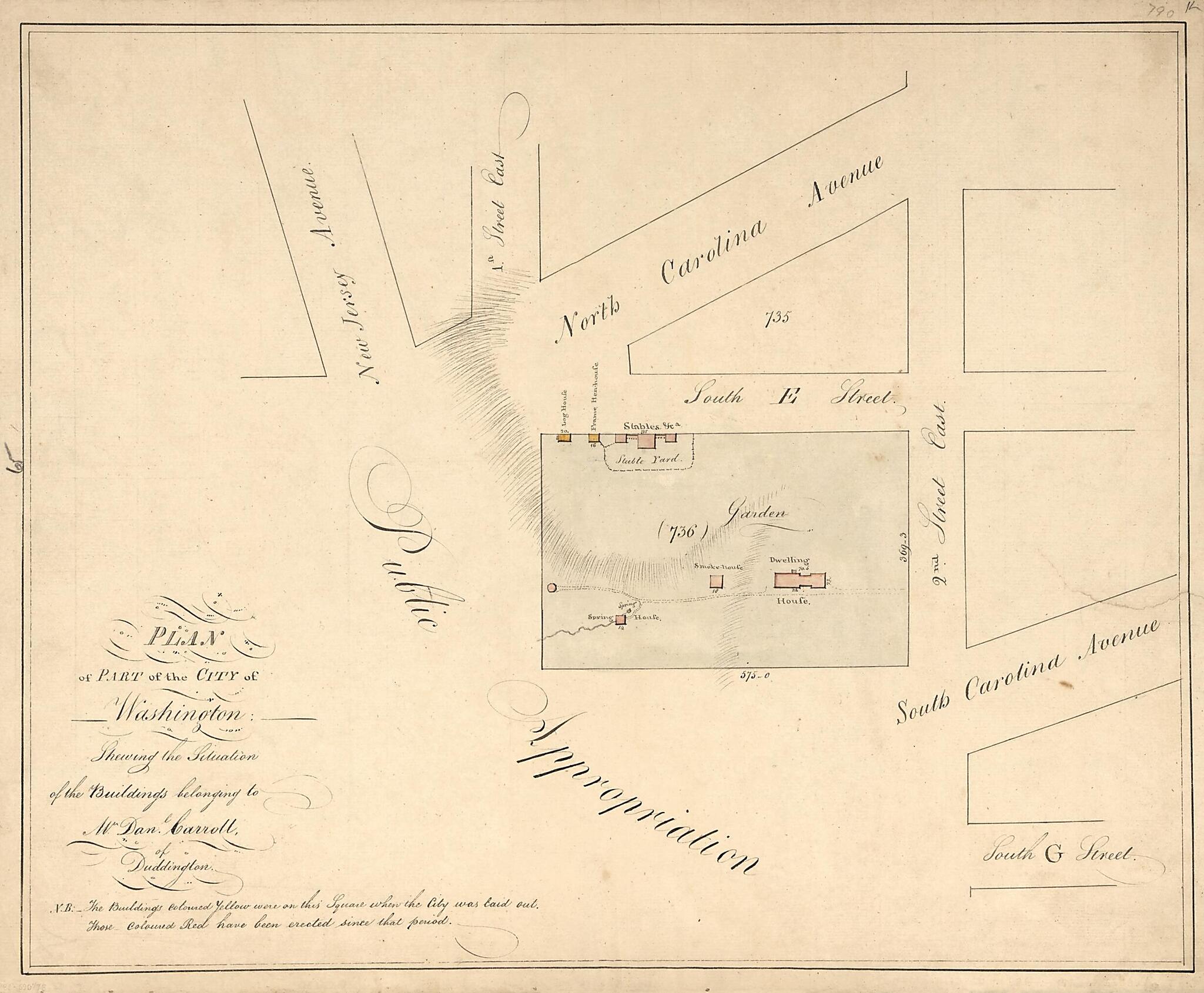
Plan of Part of the City of Washington Shewing the Situation of the Buildings Belonging to Mr. Dan'l Carroll of Duddington 1796
- Regular price
-
$54.95 - Regular price
-
$30.95 - Sale price
-
$54.95
Shipping calculated at checkout.
Buy one map, get any other map in our collection for 50% OFF! Add to cart to see discount.
Couldn't load pickup availability
About This Map
Old manuscript map / early map of Capital Hill (Washington), Capitol Hill, District of Columbia, United States, Washington, Washington D.C..
Created by N. (Nicholas) King in 1796.
Created by N. (Nicholas) King in 1796.
- Relief shown by hachures.
- Covers area bounded by 1st and 2nd streets and North and South Carolina avenues S.E., Capitol Hill, Washington D.C.
- Shows block numbers, dimensions, buildings, and function of buildings.
- Pen-and-ink and watercolor.
- Watermarked: 1794, [fleur-de-lis].
- Mounted on cloth backing.
- Accompanied by fact sheet. 1 sheet ; 61 x 46 cm.
- Includes note.
- Cited in preliminary cataloging: Toner collection 19
- Phillips. Washington, 350
Map Subjects
Capital Hill (Washington)
Capitol Hill (Washington D.C.)
Carroll Daniel
District Of Columbia
Early Maps
Early Works To 1800
Homes And Haunts
Manuscript Maps
Real Property
United States
Washington
Washington (D.C.)
Capitol Hill
Washington D.C.
Manuscript Maps
Early Maps
N. (Nicholas) King
1796
Map Sizing Information
- For the best legibility, order your map in the original size or larger. Most maps have intricate detail and small text that is best appreciated when the print size hasn't been reduced.
- Sizes labeled "Fits a Standard Frame" will drop right into any frame that you purchase in that size. The sizes that we offer are commonly available online and at most retail stores.
- Our standard sizes are recommendations based on the aspect ratio of the original map, but still may require some added "white space" in one dimension to fit.
- Non-standard sizes will require custom framing, and we suggest taking your print to the frame shop of your choice after you receive it for the best results.
- Custom sizes are available, simply contact us for a quote.
Below is an approximation of the scale of a few standard sizes, and how they might appear in your space.

