
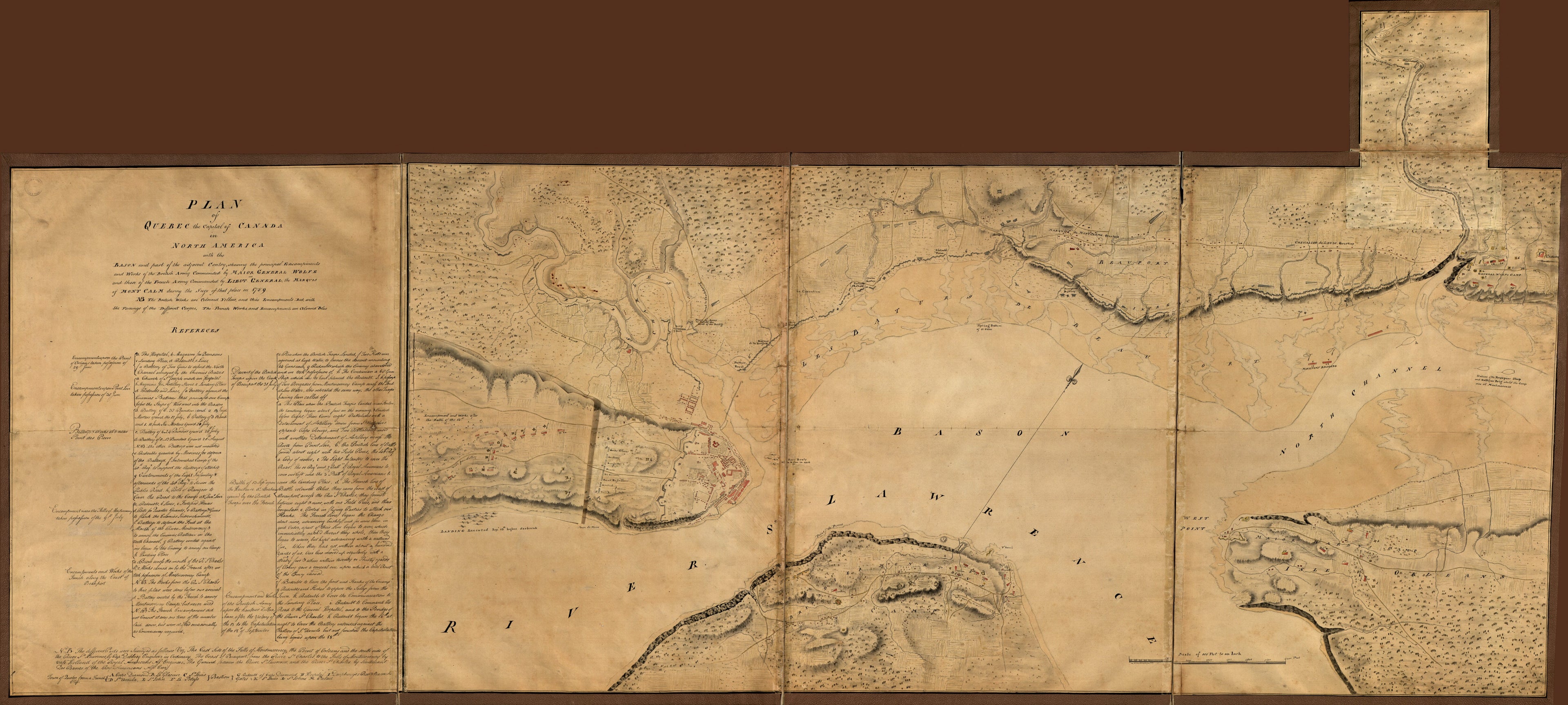
Plan of Quebec, the Capital of Canada In North America, With the Bason and Part of the Adjacent Contry sic Shewing the Principal Encampments and Works of the British Army Commanded by Maior General Wolfe and Those of the French Army Commanded by Lieut...
- Regular price
-
$217.95 - Regular price
-
$212.95 - Sale price
-
$217.95
Shipping calculated at checkout.
Buy one map, get any other map in our collection for 50% OFF! Add to cart to see discount.
Couldn't load pickup availability
About This Map
Old map of Canada, Québec.
- Relief shown by shading.
- "NB. The British works are coloured yellow and thier [sic] encampments red with the faceings [sic] of the different corpes [sic]. The French works and encampments are coloured blue."
- "N.B. The different parts were surveyed as follows viz, the east side of the Falls of Montmorency, the Point of Orleans, and the south side of the River St. Lawrence by Capt. Debbieg, engineer in ordinary. The coast of Beauport from the River St. Charles to the Falls of Montmorency by Capt. Holland of the Royal Americans as engineer. The ground between the River St. Lawrence and the River St. Charles by Lieutenant Des Barres of the Roy. Americans as eng.
- Pen-and-ink and watercolor.
- A small map showing "Encampment and works after the battle of the 13th" affixed to the left border over the area "Hauteur D'Abraham" prior to the battle.
- Includes text and index.
Map Sizing Information
- For the best legibility, order your map in the original size or larger. Most maps have intricate detail and small text that is best appreciated when the print size hasn't been reduced.
- Sizes labeled "Fits a Standard Frame" will drop right into any frame that you purchase in that size. The sizes that we offer are commonly available online and at most retail stores.
- Our standard sizes are recommendations based on the aspect ratio of the original map, but still may require some added "white space" in one dimension to fit.
- Non-standard sizes will require custom framing, and we suggest taking your print to the frame shop of your choice after you receive it for the best results.
- Custom sizes are available, simply contact us for a quote.
Below is an approximation of the scale of a few standard sizes, and how they might appear in your space.
