
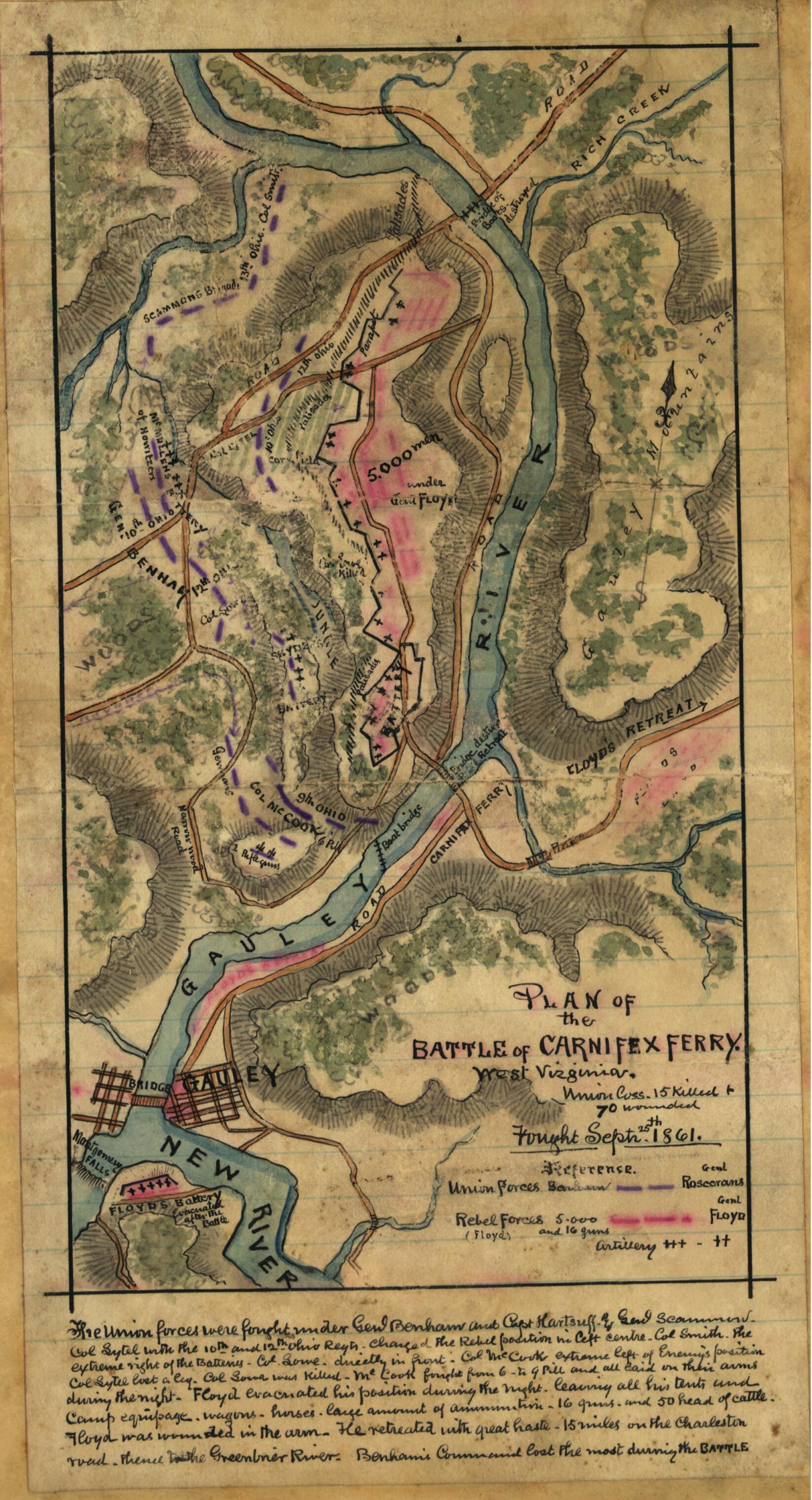
Plan of the Battle of Carnifex Ferry, West Virginia 09-25
- Regular price
-
$49.95 - Regular price
-
$29.95 - Sale price
-
$49.95
Shipping calculated at checkout.
Buy one map, get any other map in our collection for 50% OFF! Add to cart to see discount.
Couldn't load pickup availability
About This Map
Old map of Carnifex Ferry, United States, West Virginia.
Carnifex Ferry is located on the Gauley River east of the town of Gauley Bridge. Floyd's Confederate forces are positioned with their backs to the Gauley River, and the Union is shown attacking chiefly in the center and on the left.
Created by Robert Knox Sneden in 09-25.
Carnifex Ferry is located on the Gauley River east of the town of Gauley Bridge. Floyd's Confederate forces are positioned with their backs to the Gauley River, and the Union is shown attacking chiefly in the center and on the left.
Created by Robert Knox Sneden in 09-25.
- Color coding indicates the location of Union and Confederate forces.
- Relief shown by hachures.
- The Union forces were fought under Genl. Benham and Capt. Hartsuff and Genl. Scammon. Col. Lytel [sic] with the 10th and 12th Ohio Regts. charged the Rebel position in left centre. Col. Smith, the extreme right of the batteries. Col. Lowe directly in front. Col. McCook extreme left of Enemy's position. Col. Lytel [sic] lost a leg. Col. Lowe was killed. McCook fought from 6 to 9 PM. and all laid on their arms during the night. Floyd evacuated his position during the night, leaving all his tents and camp equipage, wagons, horses, large amount of ammunition, 16 guns and 50 head of cattle. Floyd was wounded in the arm. He retreated with great haste, 15 miles on the Charleston road, thence to the Green River. Benham's command lost most during the battle."--Page caption.
- This item is from the collections of the Virginia Historical Society; please contact the institution for more information.
- In the Robert Knox Sneden Scrapbook (Mss5:7 Sn237:1 p. 436).
- Manuscripts
Map Sizing Information
- For the best legibility, order your map in the original size or larger. Most maps have intricate detail and small text that is best appreciated when the print size hasn't been reduced.
- Sizes labeled "Fits a Standard Frame" will drop right into any frame that you purchase in that size. The sizes that we offer are commonly available online and at most retail stores.
- Our standard sizes are recommendations based on the aspect ratio of the original map, but still may require some added "white space" in one dimension to fit.
- Non-standard sizes will require custom framing, and we suggest taking your print to the frame shop of your choice after you receive it for the best results.
- Custom sizes are available, simply contact us for a quote.
Below is an approximation of the scale of a few standard sizes, and how they might appear in your space.

