
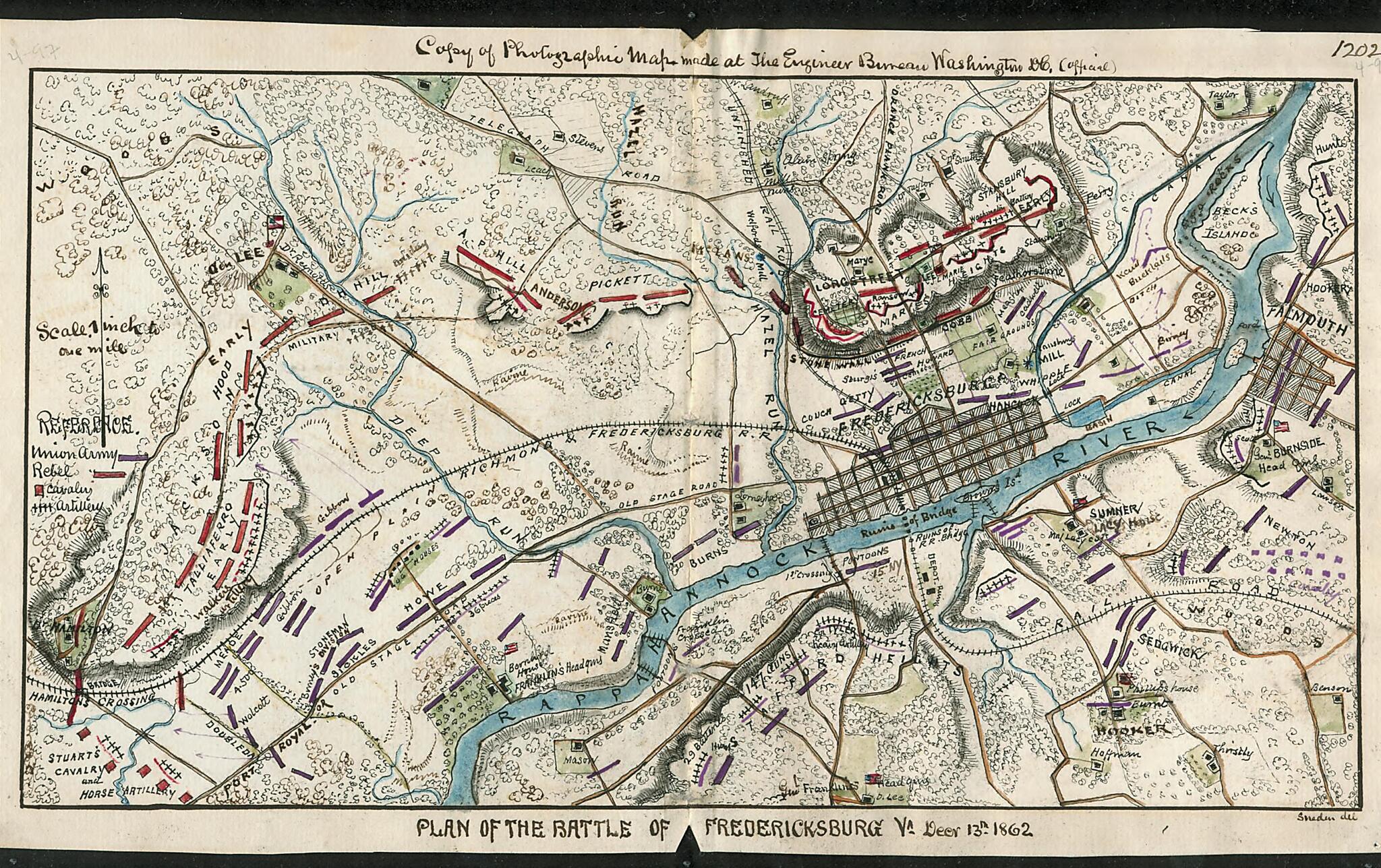
Plan of the Battle of Fredericksburg, Va., Decr. 13, 1862 12-13
- Regular price
-
$49.95 - Regular price
-
$29.95 - Sale price
-
$49.95
Shipping calculated at checkout.
Buy one map, get any other map in our collection for 50% OFF! Add to cart to see discount.
Couldn't load pickup availability
About This Map
Old map of Fredericksburg, Fredericksburg Region, United States, Virginia.
Map shows the region surrounding Fredericksburg, Va., including Marie's Heights outside of the city and Falmouth across the Rappahannock River. Due to Burnside's slow maneuvering of the Union forces, Lee was able to use the bluffs overlooking the river to his advantage. After sustaining heavy losses crossing the river, Burnside decided against renewed attacks and withdrew on the 15th of December.
Created by Robert Knox Sneden in 12-13.
- Color coding indicates the location of Union and Confederate forces.
- Relief shown by hachures.
- This item is from the collections of the Virginia Historical Society; please contact the institution for more information.
- In the Robert Knox Sneden Diary (Mss5:1 Sn237:1 v. 4, p. 97-98).
- Manuscripts
Map Subjects
Burnside Ambrose Everett
Civil War
Fredericksburg (Va.)
Fredericksburg Region
Fredericksburg Battle Of Fredericksburg VA
Fredericksburg Battle Of Fredericksburg Va.
History
United States
Virginia
Fredericksburg
Robert Knox Sneden
12-13
Map Sizing Information
- For the best legibility, order your map in the original size or larger. Most maps have intricate detail and small text that is best appreciated when the print size hasn't been reduced.
- Sizes labeled "Fits a Standard Frame" will drop right into any frame that you purchase in that size. The sizes that we offer are commonly available online and at most retail stores.
- Our standard sizes are recommendations based on the aspect ratio of the original map, but still may require some added "white space" in one dimension to fit.
- Non-standard sizes will require custom framing, and we suggest taking your print to the frame shop of your choice after you receive it for the best results.
- Custom sizes are available, simply contact us for a quote.
Below is an approximation of the scale of a few standard sizes, and how they might appear in your space.
