
Plan of the Battle of Fredericksburg, Virginia : Shewing sic Union and Rebel Positions 13th Decr 1862 12-13
- Regular price
-
$49.95 - Regular price
-
$34.95 - Sale price
-
$49.95
Shipping calculated at checkout.
Buy one map, get any other map in our collection for 50% OFF! Add to cart to see discount.
Couldn't load pickup availability
About This Map
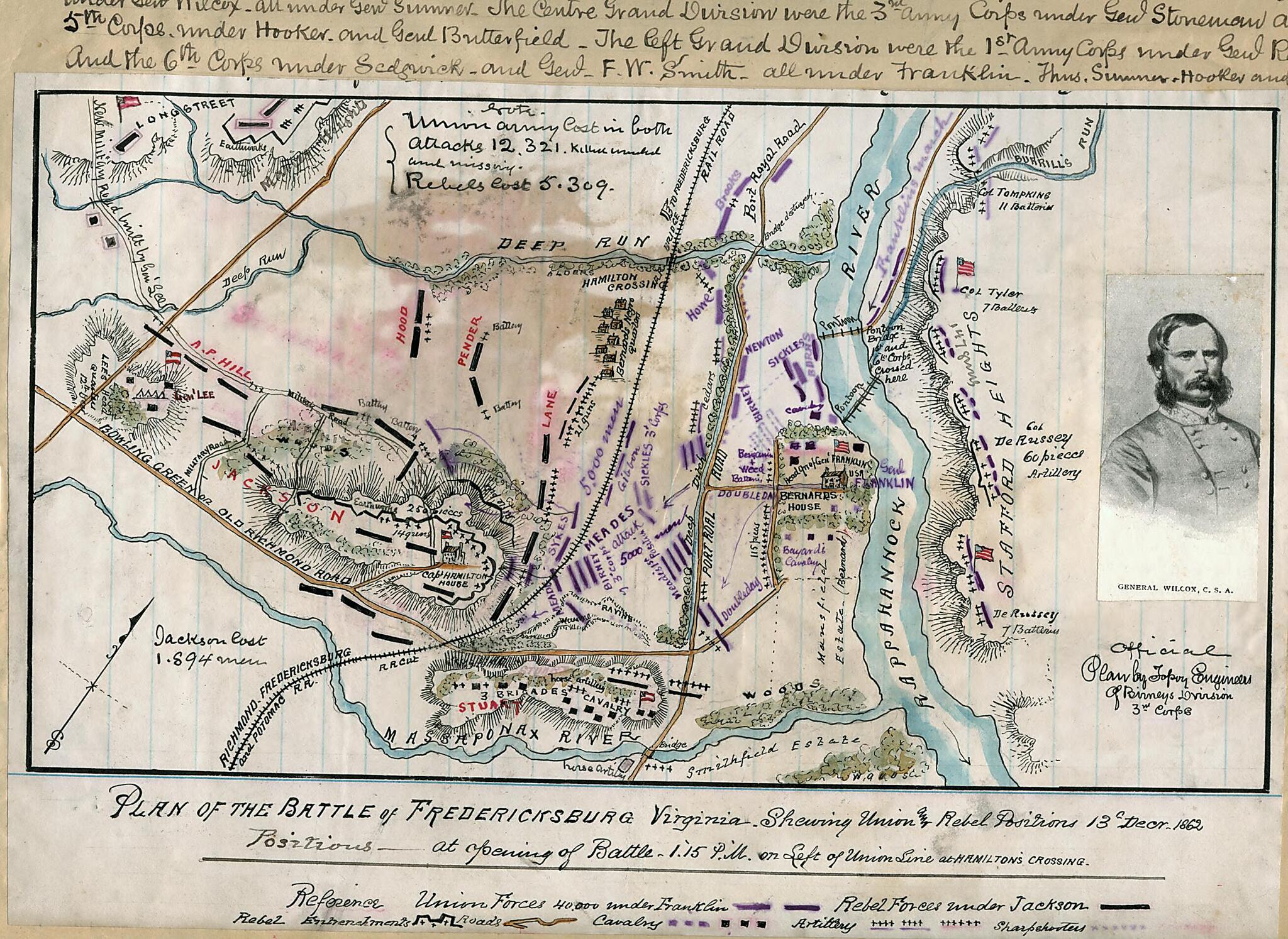
Old map of Fredericksburg Region, United States, Virginia.
The map shows positions at the beginning of the battle, with the bulk the of Union Army located across the Rappahannock from Fredericksburg, awaiting the construction of a pontoon bridge. Once across, the Union forces were met with fierce opposition from Confederate forces located in the hills to the west and south of the town.
Depicts the area surrounding Fredericksburg and on both sides of the Rappahannock River, including Stafford Heights, where Federal artillery dominated the battlefield and prevented a Confederate counterattack.
Created by Robert Knox Sneden in 12-13.
- Color coding indicates the location of Union and Confederate forces.
- Relief shown by hachures.
- This item is from the collections of the Virginia Historical Society; please contact the institution for more information.
- Robert Knox Sneden Diary (Mss5:1 Sn237:1), Virginia Historical Society, Richmond, Va.
- In the Robert Knox Sneden Scrapbook (Mss5:7 Sn237:1 p. 243).
- Manuscripts
Map Subjects
Fredericksburg Region
Fredericksburg Battle Of Fredericksburg VA
Fredericksburg Battle Of Fredericksburg Va.
United States
Virginia
Robert Knox Sneden
12-13
Map Sizing Information
- For the best legibility, order your map in the original size or larger. Most maps have intricate detail and small text that is best appreciated when the print size hasn't been reduced.
- Sizes labeled "Fits a Standard Frame" will drop right into any frame that you purchase in that size. The sizes that we offer are commonly available online and at most retail stores.
- Our standard sizes are recommendations based on the aspect ratio of the original map, but still may require some added "white space" in one dimension to fit.
- Non-standard sizes will require custom framing, and we suggest taking your print to the frame shop of your choice after you receive it for the best results.
- Custom sizes are available, simply contact us for a quote.
Below is an approximation of the scale of a few standard sizes, and how they might appear in your space.

