
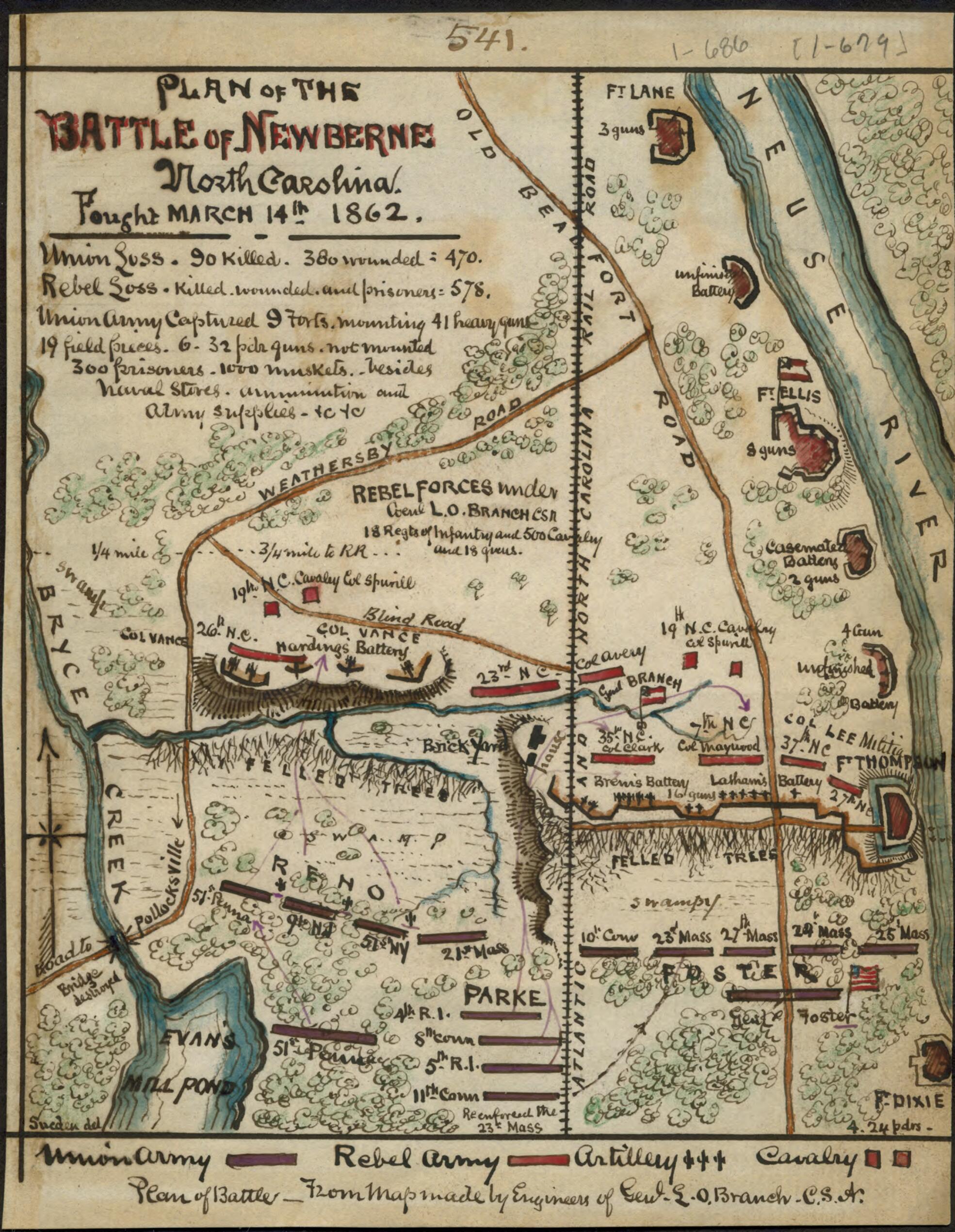
Plan of the Battle of Newberne ! North Carolina : Fought March 14th 1862 03-14
- Regular price
-
$49.95 - Regular price
-
$29.95 - Sale price
-
$49.95
Shipping calculated at checkout.
Buy one map, get any other map in our collection for 50% OFF! Add to cart to see discount.
Couldn't load pickup availability
About This Map
Old map of New Bern, North Carolina, United States.
Shows the area between Old Beaufort Road and the Neuse River to the north and Evan's Mill Pond to the south. The locations of forts Lane, Ellis, Thompson, and Dixie are indicated.
Created by Robert Knox Sneden in 03-14.
Shows the area between Old Beaufort Road and the Neuse River to the north and Evan's Mill Pond to the south. The locations of forts Lane, Ellis, Thompson, and Dixie are indicated.
Created by Robert Knox Sneden in 03-14.
- "Union loss 90 killed - 380 wounded = 470. Rebel loss killed and wounded and prisoners = 578. Union army captured 9 forts mounting 41 heavy guns 19 field pieces 6 32 pdr guns not mounted. 300 prisoners 1000 muskets besides naval stores + ammunition and army supplies etc." -- Page caption.
- Color coding indicates the location of Union and Confederate forces.
- Relief shown by hachures.
- This item is from the collections of the Virginia Historical Society; please contact the institution for more information.
- Robert Knox Sneden Scrapbook (Mss5:7 Sn237:1), Virginia Historical Society, Richmond, Va.
- In the Robert Knox Sneden Diary (Mss5:1 Sn237:1 v. 1, p. 686).
- Manuscripts
Map Sizing Information
- For the best legibility, order your map in the original size or larger. Most maps have intricate detail and small text that is best appreciated when the print size hasn't been reduced.
- Sizes labeled "Fits a Standard Frame" will drop right into any frame that you purchase in that size. The sizes that we offer are commonly available online and at most retail stores.
- Our standard sizes are recommendations based on the aspect ratio of the original map, but still may require some added "white space" in one dimension to fit.
- Non-standard sizes will require custom framing, and we suggest taking your print to the frame shop of your choice after you receive it for the best results.
- Custom sizes are available, simply contact us for a quote.
Below is an approximation of the scale of a few standard sizes, and how they might appear in your space.

