
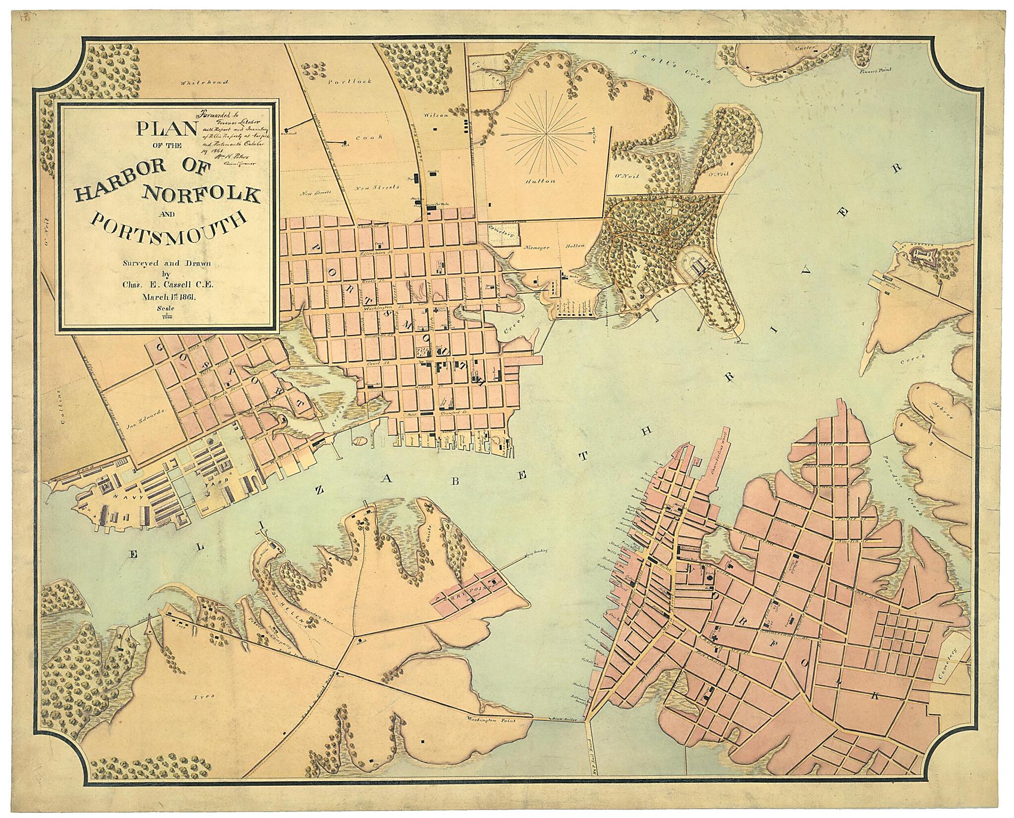
Plan of the Harbor of Norfolk and Portsmouth, March 1st, 1861
- Regular price
-
$68.95 - Regular price
-
$63.95 - Sale price
-
$68.95
Shipping calculated at checkout.
Buy one map, get any other map in our collection for 50% OFF! Add to cart to see discount.
Couldn't load pickup availability
About This Map
Old map of Hampton Roads Region, Norfolk Region, Portsmouth Region, United States, Virginia.
Created by Charles E. Cassell in 1861.
Created by Charles E. Cassell in 1861.
- "Forwarded to Governor Letcher With Report and Inventory of Public Property at Norfolk and Portsmouth October 19, 1861, Wm. H. Peters, Commissioner." Peters' report is Document 40 in: Journals and papers of the Virginia State Convention of 1861, v. 3, Documents (JK3925 1861 .A25 1966). Also mentioned: Plan of grounds at Fort Norfolk showing location of magazine, pier, &c., June 30th, 1860, by Cassell (G3884 .N6:2F6S5 1860 .C3).
- Oriented with north toward the upper right.
- Pen and ink and watercolor.
- Shows public property, landowners, vegetation, streets, railroads, and includes Fort Norfolk.
- This item is in the Map Collection of the Library of Virginia; please contact the Library's Archives Research Services department for more information.
- Swem, C.E. Maps relating to Virginia, 924
- C.1, Sept. 2001, transferred, gift, ALE; c.2, photocopy, LVA, ALE.
Map Subjects
Civil War
Hampton Roads Region
Hampton Roads Region (Va.)
History
Landowners
Maps Manuscript
Norfolk Region
Norfolk Region (Va.)
Portsmouth Region
Portsmouth Region (Va.)
United States
Virginia
Charles E. Cassell
1861
Map Sizing Information
- For the best legibility, order your map in the original size or larger. Most maps have intricate detail and small text that is best appreciated when the print size hasn't been reduced.
- Sizes labeled "Fits a Standard Frame" will drop right into any frame that you purchase in that size. The sizes that we offer are commonly available online and at most retail stores.
- Our standard sizes are recommendations based on the aspect ratio of the original map, but still may require some added "white space" in one dimension to fit.
- Non-standard sizes will require custom framing, and we suggest taking your print to the frame shop of your choice after you receive it for the best results.
- Custom sizes are available, simply contact us for a quote.
Below is an approximation of the scale of a few standard sizes, and how they might appear in your space.

