
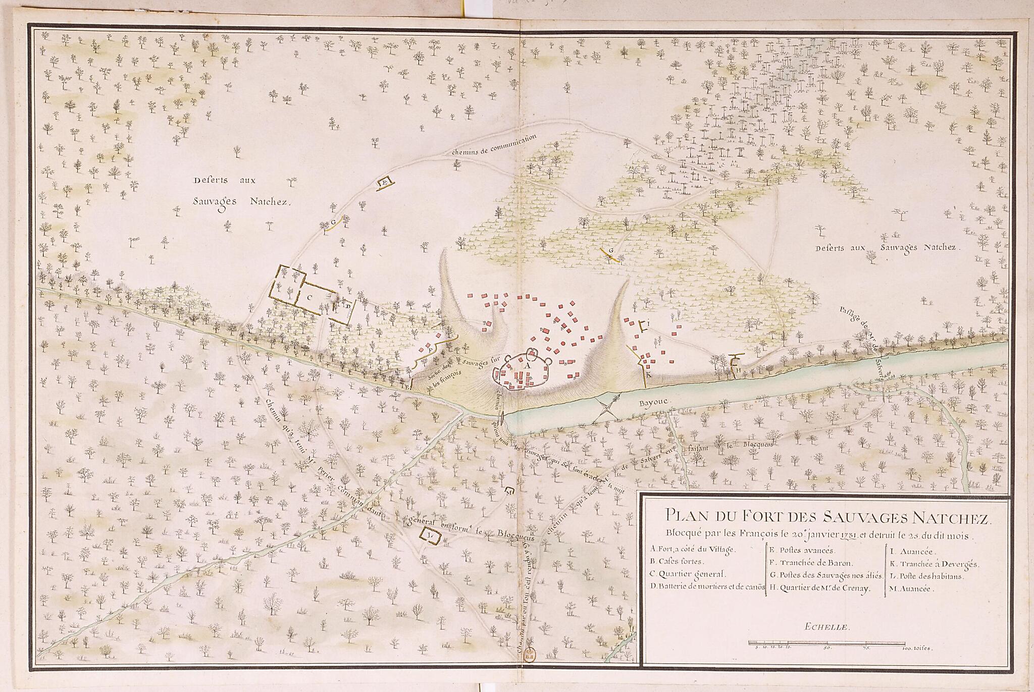
Plan of the Natchez Fort, Blockaded by the French On January 20, 1731, and Destroyed On the 25th of Said Month. (Plan Du Fort Des Sauvages Natchez Blocqué Par Les François Le 20e Janvier 1731 Et Détruit Le 25 Du Dit Mois)
- Regular price
-
$49.95 - Regular price
-
$34.95 - Sale price
-
$49.95
Shipping calculated at checkout.
Buy one map, get any other map in our collection for 50% OFF! Add to cart to see discount.
Couldn't load pickup availability
About This Map
Old map of Louisiana, Sicily Island, United States of America.
day Natchez, Mississippi), near several Indian villages. On November 28, 1729, the Natchez staged an uprising, the principal cause of which was the attempt by a French commander to relocate an Indian village in order to establish a new plantation. The Indians killed more than 200 French soldiers and colonists, while taking prisoner 50 women and children as well as at least 150 African slaves, many of whom sought to win their freedom by siding with the Indians. Fearing a general Indian uprising, the French responded by systematically attacking the Natchez and destroying their villages. This campaign culminated at the site shown on the map. Forces under Governor Étienne Périer blockaded the Natchez stronghold on January 20, 1731, and destroyed it five days later. Some 450 women and children and 40 warriors were captured. Périer sent the captives to New Orleans, where many died; the rest were sold as slaves in Saint-Domingue (present-day Haiti). Only about 200 Natchez managed to escape, finding refuge among the Chickasaws. Following this conflict, the Natchez were scattered and all but ceased to exist as a nation. Surviving members of the tribe settled among the Creeks, Chickasaws, and eventually the Cherokees. The map shows the roads taken by Périer's forces, the Natchez village and fort, the organization of the blockade, and the route taken by those Indians who managed to escape during the night. Scale is indicated in toises, an old French unit of measurement; one toise equals about 1.95 meters. The site of the siege is on swampy terrain located some six kilometers north of the present-day village of Sicily Island, Catahoula Parish, Louisiana.
day Natchez, Mississippi), near several Indian villages. On November 28, 1729, the Natchez staged an uprising, the principal cause of which was the attempt by a French commander to relocate an Indian village in order to establish a new plantation. The Indians killed more than 200 French soldiers and colonists, while taking prisoner 50 women and children as well as at least 150 African slaves, many of whom sought to win their freedom by siding with the Indians. Fearing a general Indian uprising, the French responded by systematically attacking the Natchez and destroying their villages. This campaign culminated at the site shown on the map. Forces under Governor Étienne Périer blockaded the Natchez stronghold on January 20, 1731, and destroyed it five days later. Some 450 women and children and 40 warriors were captured. Périer sent the captives to New Orleans, where many died; the rest were sold as slaves in Saint-Domingue (present-day Haiti). Only about 200 Natchez managed to escape, finding refuge among the Chickasaws. Following this conflict, the Natchez were scattered and all but ceased to exist as a nation. Surviving members of the tribe settled among the Creeks, Chickasaws, and eventually the Cherokees. The map shows the roads taken by Périer's forces, the Natchez village and fort, the organization of the blockade, and the route taken by those Indians who managed to escape during the night. Scale is indicated in toises, an old French unit of measurement; one toise equals about 1.95 meters. The site of the siege is on swampy terrain located some six kilometers north of the present-day village of Sicily Island, Catahoula Parish, Louisiana.
- Title devised, in English, by Library staff.
- Original resource extent: 1 drawing : pen, ink wash and watercolor ; 44 x 67 centimeters.
- Original resource at: National Library of France.
- Content in French.
- Description based on data extracted from World Digital Library, which may be extracted from partner institutions.
Map Subjects
01-20 To 1731-01-22
Battles
Blockade
Colonies
Company Of The Indies
Company Of The West
Forts And Fortifications
France
France In America
Indigenous Peoples
Louisiana
Manuscript Maps
Natchez Indians
New France
Sicily Island
United States Of America
Villages
1731
Map Sizing Information
- For the best legibility, order your map in the original size or larger. Most maps have intricate detail and small text that is best appreciated when the print size hasn't been reduced.
- Sizes labeled "Fits a Standard Frame" will drop right into any frame that you purchase in that size. The sizes that we offer are commonly available online and at most retail stores.
- Our standard sizes are recommendations based on the aspect ratio of the original map, but still may require some added "white space" in one dimension to fit.
- Non-standard sizes will require custom framing, and we suggest taking your print to the frame shop of your choice after you receive it for the best results.
- Custom sizes are available, simply contact us for a quote.
Below is an approximation of the scale of a few standard sizes, and how they might appear in your space.
