
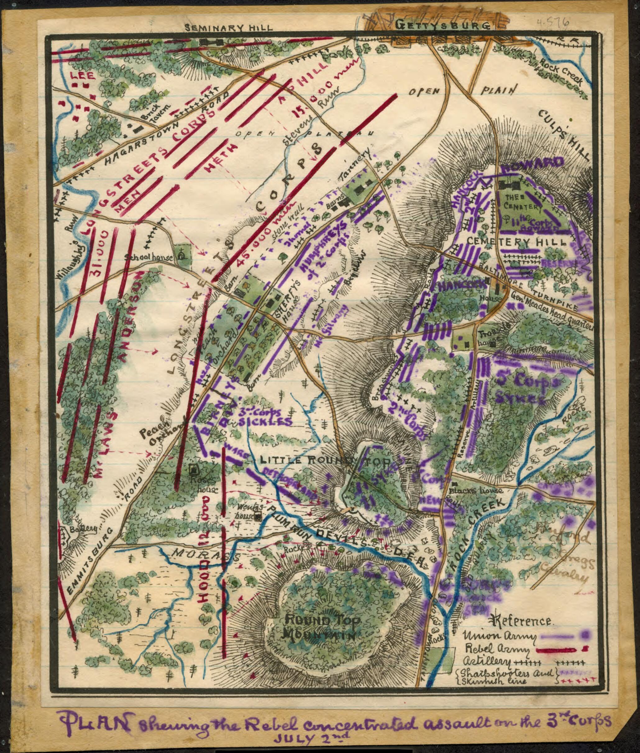
Plan Shewing sic the Rebel Concentrated Assault On the 3rd Corps, July 2nd 07-02
- Regular price
-
$49.95 - Regular price
-
$29.95 - Sale price
-
$49.95
Shipping calculated at checkout.
Buy one map, get any other map in our collection for 50% OFF! Add to cart to see discount.
Couldn't load pickup availability
About This Map
Old map of Gettysburg, Gettysburg Region, Pennsylvania, United States.
Map depicts the situation just prior to Union Gen. Daniel Edgar Sickles' having ordered his 3rd Corps into an advanced position on a ridge overlooking the Emmitsburg Road, unknowingly exposing his left flank. Confederate forces under Longstreet and Hill attacked him, overwhelming the Union position and forcing the troops back, thereby succeeding in forming a wedge between the 2nd and 3rd Corps. Sickles was injured in the fighting and lost a leg as a result.
Created by Robert Knox Sneden in 07-02.
- Color coding indicates the location of Union and Confederate forces.
- Relief shown by hachures.
- This item is from the collections of the Virginia Historical Society; please contact the institution for more information.
- In the Robert Knox Sneden Diary (Mss5:1 Sn237:1 v. 4, p. 576).
- Manuscripts
Map Sizing Information
- For the best legibility, order your map in the original size or larger. Most maps have intricate detail and small text that is best appreciated when the print size hasn't been reduced.
- Sizes labeled "Fits a Standard Frame" will drop right into any frame that you purchase in that size. The sizes that we offer are commonly available online and at most retail stores.
- Our standard sizes are recommendations based on the aspect ratio of the original map, but still may require some added "white space" in one dimension to fit.
- Non-standard sizes will require custom framing, and we suggest taking your print to the frame shop of your choice after you receive it for the best results.
- Custom sizes are available, simply contact us for a quote.
Below is an approximation of the scale of a few standard sizes, and how they might appear in your space.

