
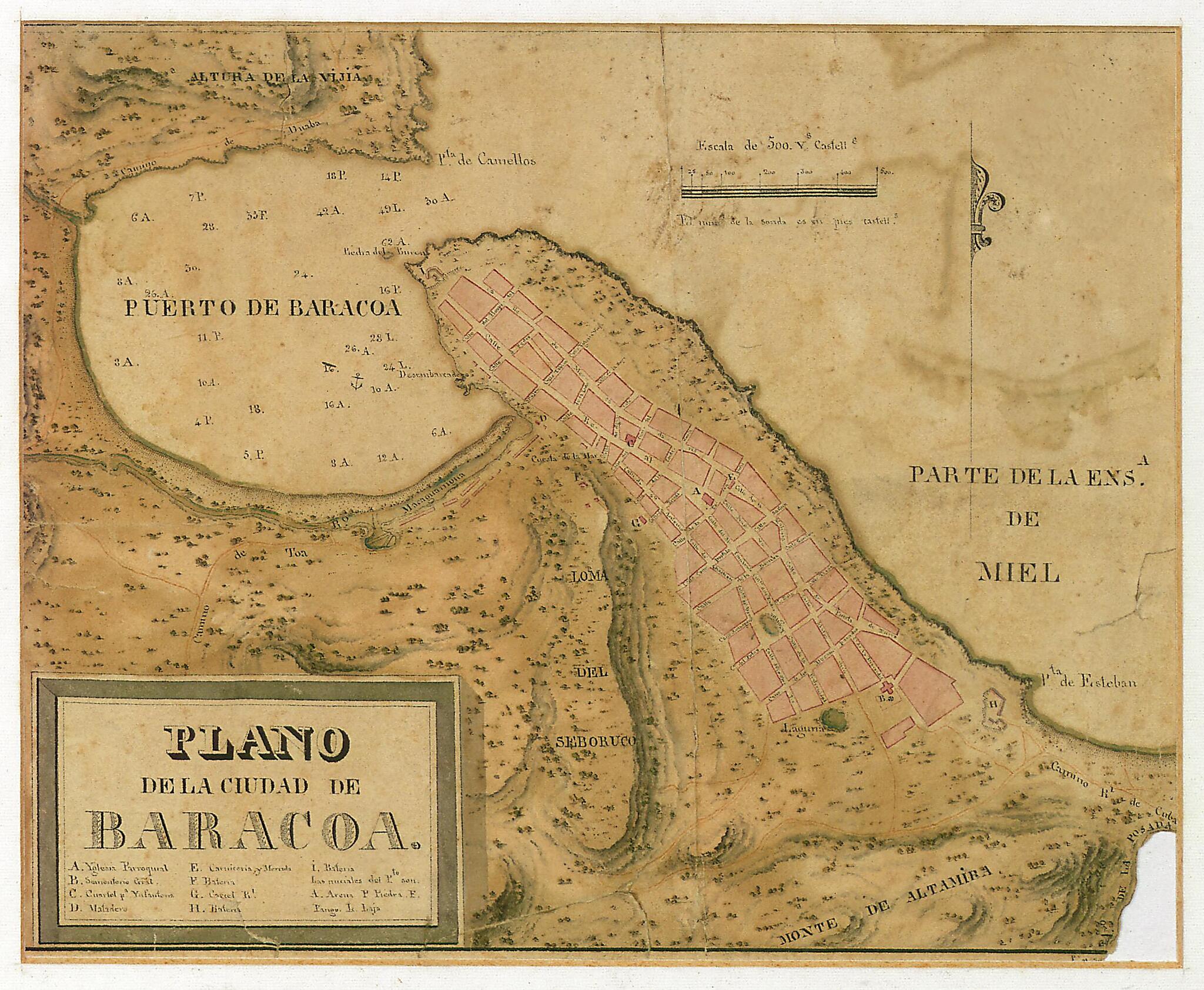
Map of the City of Baracoa. (Plano De La Ciudad De Baracoa) 1831
- Regular price
-
$49.95 - Regular price
-
$34.95 - Sale price
-
$49.95
Buy one map, get any other map in our collection for 50% OFF! Add to cart to see discount.
Couldn't load pickup availability
About This Map
Discover the timeless beauty of our fine art quality printed reproduction of this antique map. Perfect for history enthusiasts, collectors, and interior decorators.
Restored with meticulous attention to detail by our team with over a decade of experience, this stunning reproduction captures the intricate artistry and historical significance of the original map.
Whether you're a collector or seeking a unique decor piece, this archival-quality map reproduction is a timeless addition to any space. Order now to bring history to life!
Old map of Baracoa, Cuba, Guantánamo.1834) was a Spanish cartographer. He trained in the technical branch of the Spanish Navy, where he proved himself to be a skilled draftsman and mathematician. For a time he worked under the direction of Vicente Tofiño, the most-esteemed Spanish cartographer of the day, on the production of the Atlas marítimo de España (Maritime atlas of Spain). He was the cartographer aboard the corvette Descubierta on the famous Malaspina Expedition of 1789-94, which, under the command of naval officer and explorer Alessandro Malaspina, visited nearly all of the Spanish possessions in the Americas and Asia. Back in Madrid, in 1797 Bauzá was appointed director of Hydrographic Office. This pen and India ink manuscript map by Bauzá is from 1831. The map is illuminated in gouache in green, sepia, and pink. Relief is represented by shading, and roads and farm plots are shown. The letter key in the lower left indicates important buildings and structures, including the parish church, the market, and the batteries guarding the harbor. The scale is in varas castellanas (Castilian yards, an old unit of measurement that varied with time and place, equivalent to about 0.84 meters). The map has great importance from both a geographical and historic perspective. Baracoa was founded by the Spanish on August 15, 1511 under the name Villa de Nuestra Señora de la Asunción de Baracoa (City of Our Lady of Assumption of Baracoa). Located on the eastern tip of the island, on the Bahía de Miel (Bay of Honey), it is the oldest city in Cuba and the starting point for the 16th-century Spanish colonization.
Created by Felipe Bauzá, Spain. Navy. Directorate of Hydrography in 1831.
- Title devised, in English, by Library staff.
- Original resource extent: 1 manuscript map : paper, color ; 14 x 31 centimeters.
- Reference extracted from World Digital Library: Peter Barber, "'Riches for the Geography of America and Spain': Felipe Bauzá and his Topographical Collections, 1789-1848," British Library Journal 12, no. 1 (Spring 1996).
- Original resource at: National Library of Cuba "José Martí".
- Content in Spanish.
- Description based on data extracted from World Digital Library, which may be extracted from partner institutions.
Map Subjects
Baracoa
Cuba
Guantánamo
Manuscript Maps
Felipe Bauzá
Spain. Navy. Directorate Of Hydrography
1831
- For the best legibility, order your map in the original size or larger. Most maps have intricate detail and small text that is best appreciated when the print size hasn't been reduced.
- Sizes labeled "Fits a Standard Frame" will drop right into any frame that you purchase in that size. The sizes that we offer are commonly available online and at most retail stores.
- Our standard sizes are recommendations based on the aspect ratio of the original map, but still may require some added "white space" in one dimension to fit.
- Non-standard sizes will require custom framing, and we suggest taking your print to the frame shop of your choice after you receive it for the best results.
- Custom sizes are available, simply contact us for a quote.
Below is an approximation of the scale of a few standard sizes, and how they might appear in your space.

