
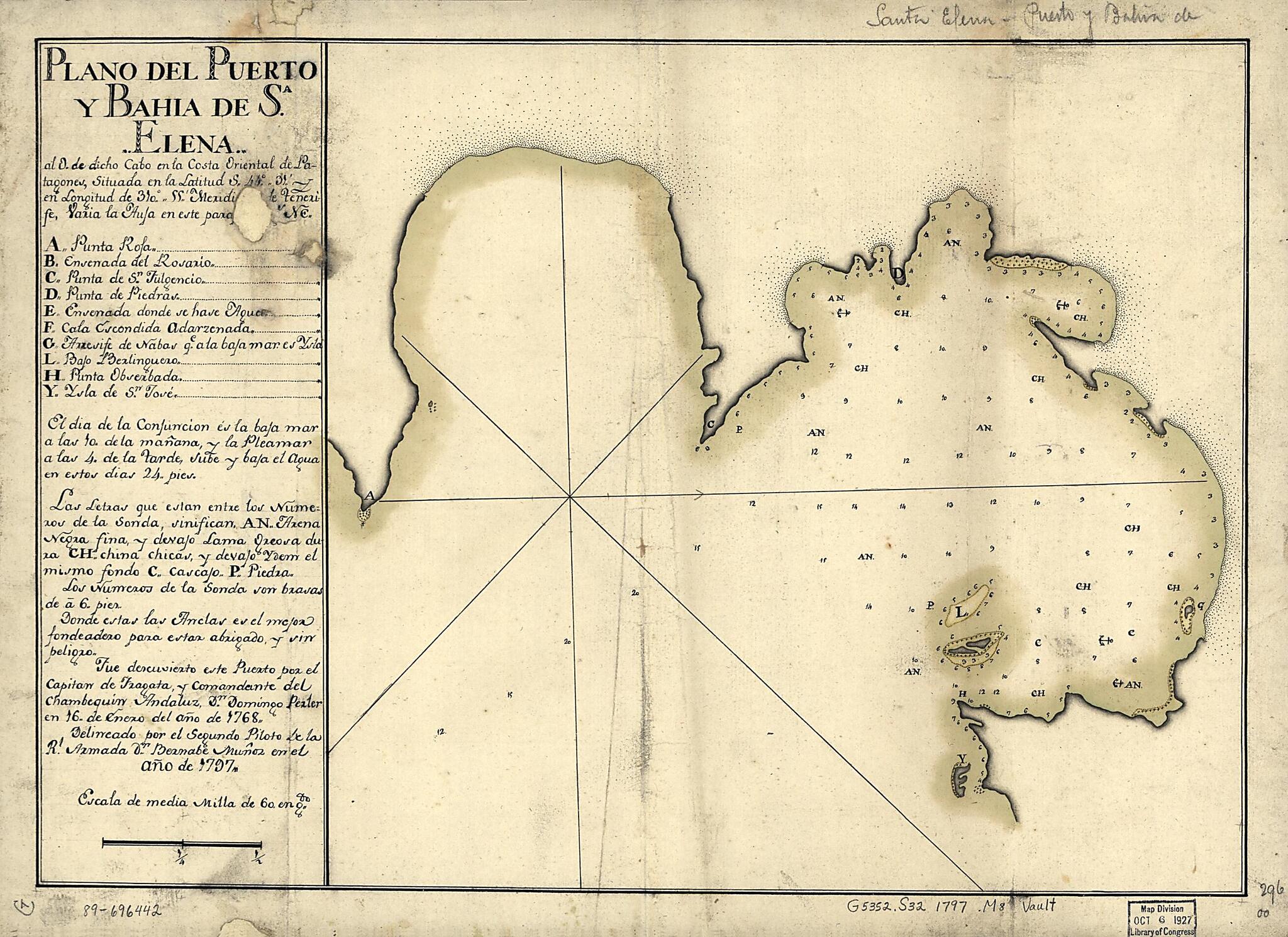
Plano Del Puerto Y Bahía De Sa. Elena Al O. De Dicho Cabo En La Costa Oriental De Patagones, Situada En La Latitud S. 44⁰ 31ʹ En Longitud De 310⁰ 55ʹ Meridiano De Tenerife, Varia La Aufa En Este Parafe 18 Gs. NE 1797
- Regular price
-
$49.95 - Regular price
-
$29.95 - Sale price
-
$49.95
Shipping calculated at checkout.
Buy one map, get any other map in our collection for 50% OFF! Add to cart to see discount.
Couldn't load pickup availability
About This Map
Old map of Argentina, Santa Elena Bay.
Created by Bernabe Muñoz in 1797.
Created by Bernabe Muñoz in 1797.
- Prime meridian: Tenerife.
- "Fue descuviento este puerto por el Capitan de Fragata y Comandante del Chambequin Andaluz Dn. Domingo Perler en 16. de enero del año de 1768."
- Depths shown by soundings.
- Oriented with north to the right.
- Watermark: J. Kool.
- Pen-and-ink and watercolor.
- Imperfect; 2 small holes.
- Mounted on cloth backing.
- Maggs number annotated in pencil in lower right margin: 296.
- Includes index and notes.
Map Subjects
Argentina
Early Works To 1800
Maps Manuscript
Santa Elena Bay
Santa Elena Bay (Argentina)
Bernabe Muñoz
1797
Map Sizing Information
- For the best legibility, order your map in the original size or larger. Most maps have intricate detail and small text that is best appreciated when the print size hasn't been reduced.
- Sizes labeled "Fits a Standard Frame" will drop right into any frame that you purchase in that size. The sizes that we offer are commonly available online and at most retail stores.
- Our standard sizes are recommendations based on the aspect ratio of the original map, but still may require some added "white space" in one dimension to fit.
- Non-standard sizes will require custom framing, and we suggest taking your print to the frame shop of your choice after you receive it for the best results.
- Custom sizes are available, simply contact us for a quote.
Below is an approximation of the scale of a few standard sizes, and how they might appear in your space.

