
Picturesque Map of Havana With House Numbers. (Plano Pintoresco De La Habana Con Los Números De Las Casas) 1849
- Regular price
-
$52.95 - Regular price
-
$47.95 - Sale price
-
$52.95
Shipping calculated at checkout.
Buy one map, get any other map in our collection for 50% OFF! Add to cart to see discount.
Couldn't load pickup availability
About This Map
Old map of Cuba, Havana.
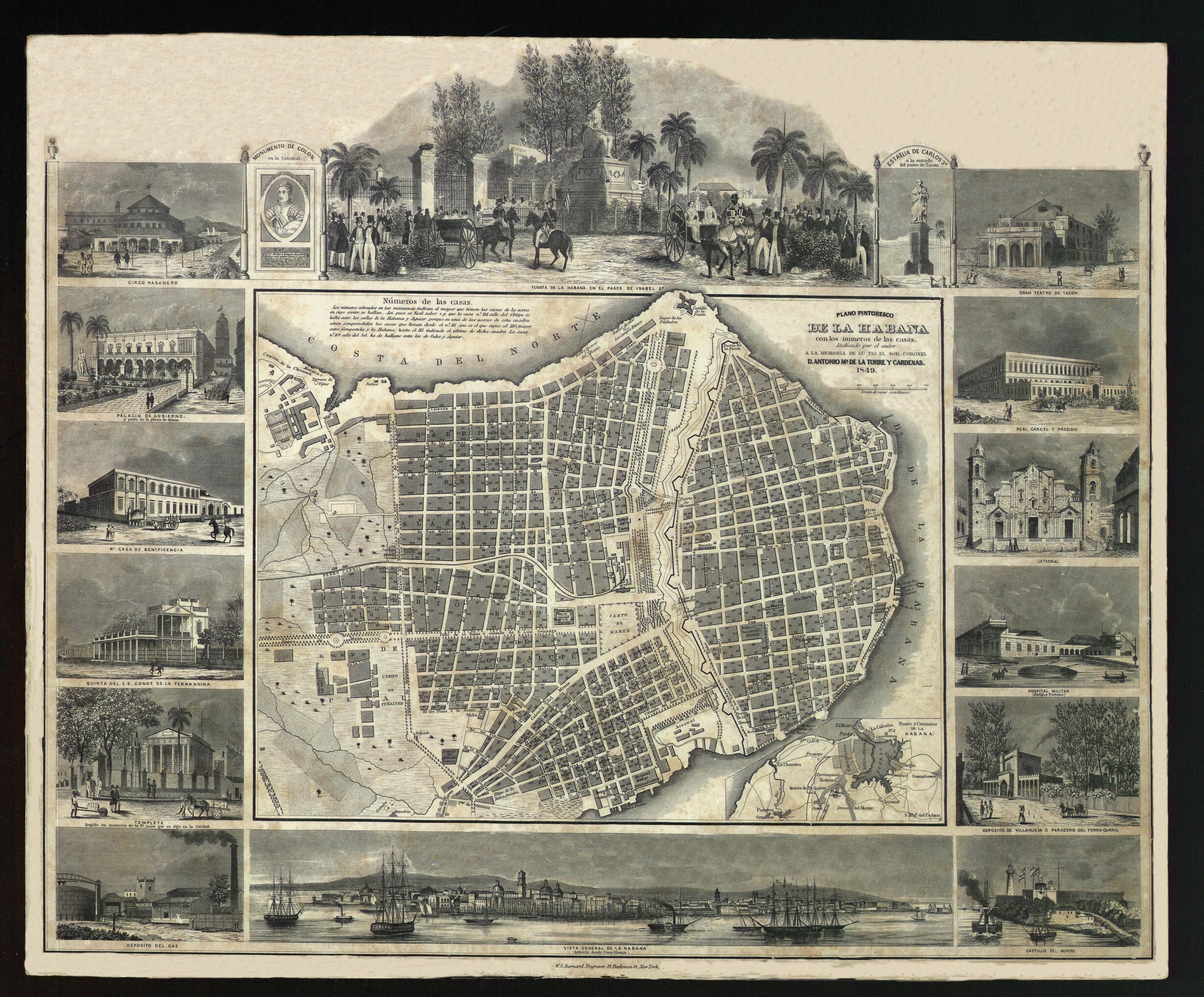
73) was a Cuban geographer, archaeologist, historian, and educator. De la Torre's 1849 Plano Pintoresco de La Habana con los números de las casas (Picturesque map of Havana with house numbers) has great importance from a geographic point of view. The map shows the names of the streets, house numbers, promenades, fortifications, and public buildings, and the division of the city by neighborhoods. The scale is in varas castellanas (Castilian yards, an old unit of measurement that varied with time and place, equivalent to about 0.84 meters). An inset map in the lower right shows the port of Havana and nearby areas, including the fortifications of El Morro, La Punta, and La Cabaña. The map is framed by 14 engraved illustrations from Album Pintoresco de La Isla de Cuba (Picturesque album of the island of Cuba) by Federico Mialhe (1810-81), giving the map an artistic beauty. The engravings depict: a fashionable crowd gathered at the Noble Havana Fountain (also known as the Indian Fountain) on Isabel II Promenade, the Gran Teatro de Tacón, the jail and penitentiary, Havana Cathedral, the military hospital, Villanueva train station, Morro Castle, a fine general view of Havana, the gas reservoir, the Templete (a monument to the religious foundation of Havana), the grand house of the Count of Fernandina, the almshouse, City Hall, and Havana circus building.
Created by William S. Barnard, Frédéric Mialhe, José María De La Torre in 1849.
- Title devised, in English, by Library staff.
- Original resource extent: 1 map : paper ; 56 x 46 centimeters.
- Original resource at: National Library of Cuba "José Martí".
- Content in Spanish.
- Description based on data extracted from World Digital Library, which may be extracted from partner institutions.
Map Sizing Information
- For the best legibility, order your map in the original size or larger. Most maps have intricate detail and small text that is best appreciated when the print size hasn't been reduced.
- Sizes labeled "Fits a Standard Frame" will drop right into any frame that you purchase in that size. The sizes that we offer are commonly available online and at most retail stores.
- Our standard sizes are recommendations based on the aspect ratio of the original map, but still may require some added "white space" in one dimension to fit.
- Non-standard sizes will require custom framing, and we suggest taking your print to the frame shop of your choice after you receive it for the best results.
- Custom sizes are available, simply contact us for a quote.
Below is an approximation of the scale of a few standard sizes, and how they might appear in your space.

