
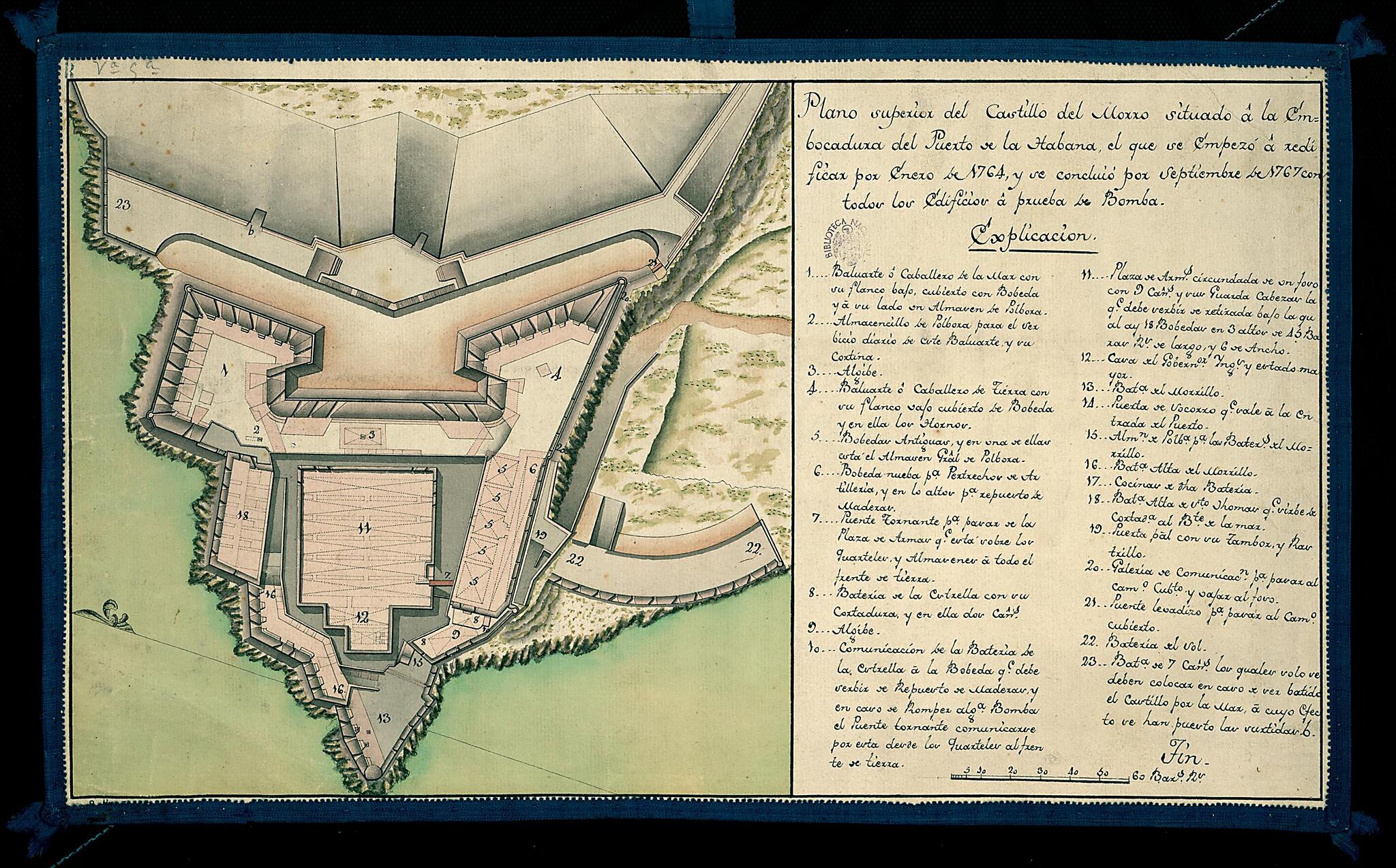
Upper View of the Castillo Del Morro Situated at the Mouth of the Bay of Havana. (Plano Superior Del Castillo Del Morro Situado En La Embocadora Del Puerto De La Habana, El Que Se Empezó a Redificar Por Enero De 1764, Y Se Concluió Por Septiembre De...
- Regular price
-
$49.95 - Regular price
-
$34.95 - Sale price
-
$49.95
Buy one map, get any other map in our collection for 50% OFF! Add to cart to see discount.
Couldn't load pickup availability
About This Map
Discover the timeless beauty of our fine art quality printed reproduction of this antique map. Perfect for history enthusiasts, collectors, and interior decorators.
Restored with meticulous attention to detail by our team with over a decade of experience, this stunning reproduction captures the intricate artistry and historical significance of the original map.
Whether you're a collector or seeking a unique decor piece, this archival-quality map reproduction is a timeless addition to any space. Order now to bring history to life!
Old map of Cuba, Havana.century manuscript map shows the plan of Morro Castle, located at the entrance of Havana Bay, Cuba. The fortress was built by the Spaniards, starting in 1585. The Italian military engineer Battista Antonelli (1547--1616) was commissioned to design the fortifications. The structure originally was conceived as a small fort surrounded by a dry moat, but it was expanded and rebuilt on several occasions and became a major fortress of great strategic importance for the island. The map is oriented with north to the left and tilted up at an acute angle. On the right side are the title and an "Explanation" that indicates, through a numeric code, the fort's bastions, bridges, cisterns, and batteries, with brief descriptions of some of these features. The map is drawn in pen on paper, with scale drawings in black ink and background in gray, pink, green, and orange sepia.
- Title devised, in English, by Library staff.
- "Scale about 1:800"--Note extracted from World Digital Library.
- Original resource extent: 1 manuscript plan ; 29 x 48.5 cenitmeters.
- Original resource at: National Library of Spain.
- Content in Spanish.
- Description based on data extracted from World Digital Library, which may be extracted from partner institutions.
Map Subjects
Architectural Drawings
Cuba
Forts And Fortifications
Havana
Manuscript Maps
1767
- For the best legibility, order your map in the original size or larger. Most maps have intricate detail and small text that is best appreciated when the print size hasn't been reduced.
- Sizes labeled "Fits a Standard Frame" will drop right into any frame that you purchase in that size. The sizes that we offer are commonly available online and at most retail stores.
- Our standard sizes are recommendations based on the aspect ratio of the original map, but still may require some added "white space" in one dimension to fit.
- Non-standard sizes will require custom framing, and we suggest taking your print to the frame shop of your choice after you receive it for the best results.
- Custom sizes are available, simply contact us for a quote.
Below is an approximation of the scale of a few standard sizes, and how they might appear in your space.
