
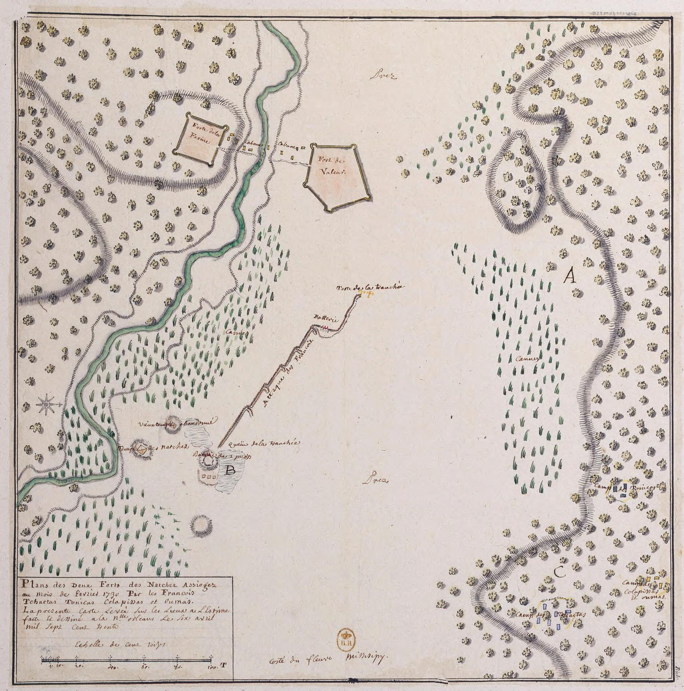
Plans Des Deux Forts Des Natchez Assiegez Au Mois De Fevrier in 1730 Par Les Français Tchactas Tonicas Colapissas Et Oumas. La Présente Carte Levée Sur Les Lieux à L'Estime Faite Et Dessinée a La N.lle Orleans Le Six Avril Mil Sept Cent Trente
- Regular price
-
$49.95 - Regular price
-
$34.95 - Sale price
-
$49.95
Shipping calculated at checkout.
Buy one map, get any other map in our collection for 50% OFF! Add to cart to see discount.
Couldn't load pickup availability
About This Map
Old map of Louisiana, Mississippi, Natchez, United States of America.
day Natchez, Mississippi), near several Indian villages. On November 28, 1729, the Natchez staged an uprising, the principal cause of which was the attempt by a French commander to relocate an Indian village in order to establish a new plantation. The Indians seized Fort Rosalie and killed more than 200 French soldiers and colonists, while taking prisoner 50 women and children as well as at least 150 African slaves, many of whom sought to win their freedom by siding with the Indians. Fearing a general Indian uprising, the French responded by systematically attacking the Natchez and destroying their villages. Early in the campaign, the French laid siege to the two Natchez forts near Fort Rosalie, assisted by their Indian allies, who included Tunica, Houma, and Choctaw. At the end of 12 days, the Natchez freed all of the captives they had taken in November and escaped under cover of night. The map shows the two forts, the Mississippi River, and the line of attack by the French and their allies. It is unknown who made the map, but a note indicates that it was drawn by hand in New Orleans on April 6, 1730. Scale is indicated in toises, an old French unit of measurement; one toise equals about 1.95 meters.
day Natchez, Mississippi), near several Indian villages. On November 28, 1729, the Natchez staged an uprising, the principal cause of which was the attempt by a French commander to relocate an Indian village in order to establish a new plantation. The Indians seized Fort Rosalie and killed more than 200 French soldiers and colonists, while taking prisoner 50 women and children as well as at least 150 African slaves, many of whom sought to win their freedom by siding with the Indians. Fearing a general Indian uprising, the French responded by systematically attacking the Natchez and destroying their villages. Early in the campaign, the French laid siege to the two Natchez forts near Fort Rosalie, assisted by their Indian allies, who included Tunica, Houma, and Choctaw. At the end of 12 days, the Natchez freed all of the captives they had taken in November and escaped under cover of night. The map shows the two forts, the Mississippi River, and the line of attack by the French and their allies. It is unknown who made the map, but a note indicates that it was drawn by hand in New Orleans on April 6, 1730. Scale is indicated in toises, an old French unit of measurement; one toise equals about 1.95 meters.
- Title devised, in English, by Library staff.
- Original resource extent: 1 drawing : pen, ink wash and watercolor ; 31 x 30.8 centimeters.
- Original resource at: National Library of France.
- Content in French.
- Description based on data extracted from World Digital Library, which may be extracted from partner institutions.
Map Sizing Information
- For the best legibility, order your map in the original size or larger. Most maps have intricate detail and small text that is best appreciated when the print size hasn't been reduced.
- Sizes labeled "Fits a Standard Frame" will drop right into any frame that you purchase in that size. The sizes that we offer are commonly available online and at most retail stores.
- Our standard sizes are recommendations based on the aspect ratio of the original map, but still may require some added "white space" in one dimension to fit.
- Non-standard sizes will require custom framing, and we suggest taking your print to the frame shop of your choice after you receive it for the best results.
- Custom sizes are available, simply contact us for a quote.
Below is an approximation of the scale of a few standard sizes, and how they might appear in your space.

