
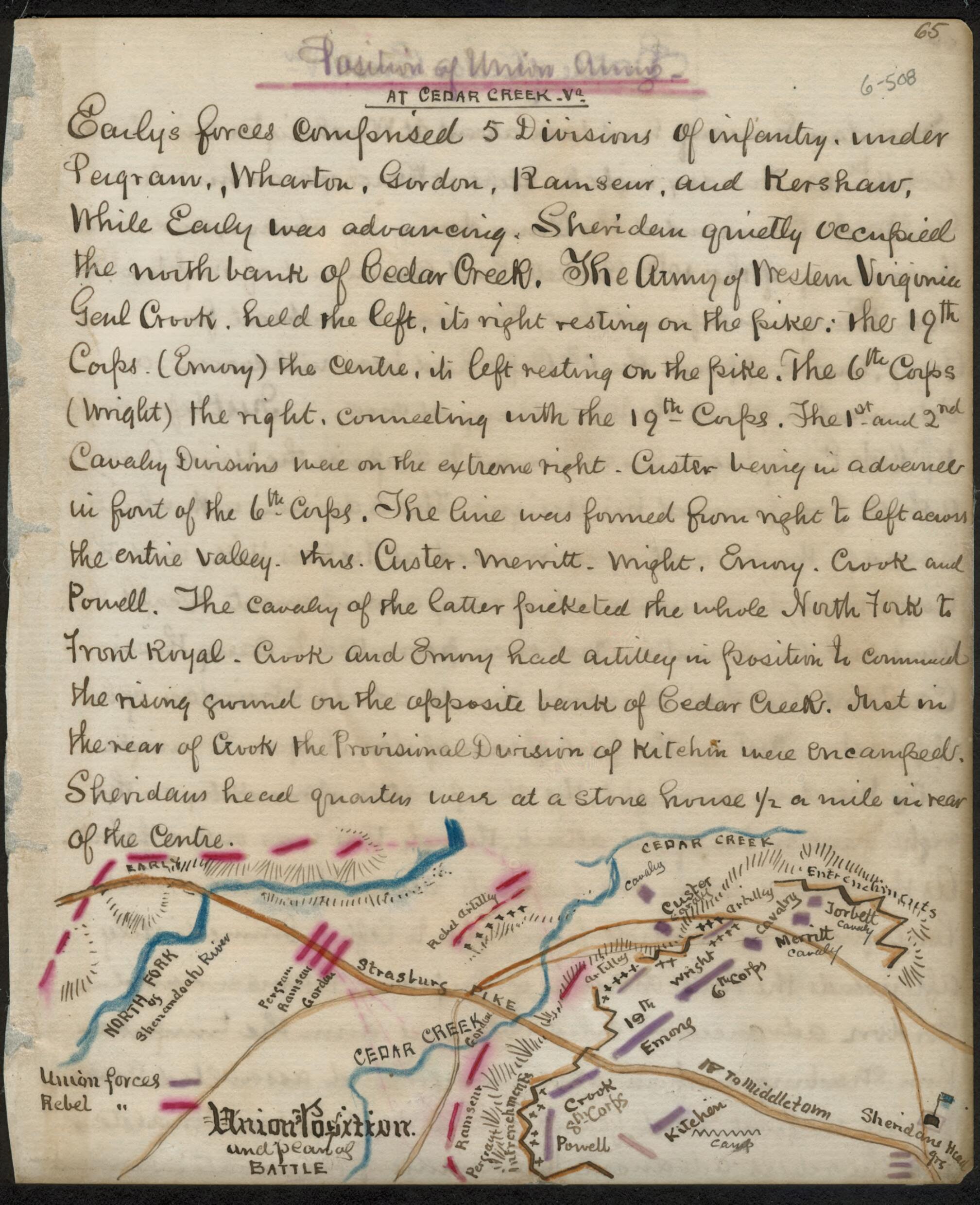
Position of Union Army at Cedar Creek Union Position and Plan of Battle 1861
- Regular price
-
$49.95 - Regular price
-
$29.95 - Sale price
-
$49.95
Shipping calculated at checkout.
Buy one map, get any other map in our collection for 50% OFF! Add to cart to see discount.
Couldn't load pickup availability
About This Map
Old map of Shenandoah County, Shenandoah River Valley, United States, Virginia, West Virginia.
However, what initially appeared to be an overwhelming success quickly turned to a rout when the Union forces were redeployed and launched a successful counterattack that drove the Confederates back across the Shenandoah to Fisher's Hill, with heavy losses of men, equipment and supplies., Map shows troop locations along the Strasburg Pike on either side of Cedar Creek, and along the north fork of the Shenandoah River. The Union army under Sheridan has paused in its movement up the Valley and is located northwest of Cedar Creek in the vicinity of Middletown and Belle Grove. Early's Confederates, having assessed the situation from their position at Fisher's Hill, decided to undertake a surprise attack on the Union rear. On the night of October 18th a portion of Early's army crossed to the south of the Shenandoah and marched east, recrossing the river at Bowman's Ford on the Union left flank. Meanwhile, several other divisions moved north along the Valley Pike in a position to launch a direct assault. Moving in before daylight, the Confederates took the Federals by complete surprise.
Created by Robert Knox Sneden in 1861.
- Color coding indicates the location of Union and Confederate forces.
- Relief shown by hachures.
- This item is from the collections of the Virginia Historical Society; please contact the institution for more information.
- In the Robert Knox Sneden Diary (Mss5:1 Sn237:1 v. 6, p. 508).
- Manuscripts
Map Sizing Information
- For the best legibility, order your map in the original size or larger. Most maps have intricate detail and small text that is best appreciated when the print size hasn't been reduced.
- Sizes labeled "Fits a Standard Frame" will drop right into any frame that you purchase in that size. The sizes that we offer are commonly available online and at most retail stores.
- Our standard sizes are recommendations based on the aspect ratio of the original map, but still may require some added "white space" in one dimension to fit.
- Non-standard sizes will require custom framing, and we suggest taking your print to the frame shop of your choice after you receive it for the best results.
- Custom sizes are available, simply contact us for a quote.
Below is an approximation of the scale of a few standard sizes, and how they might appear in your space.

