
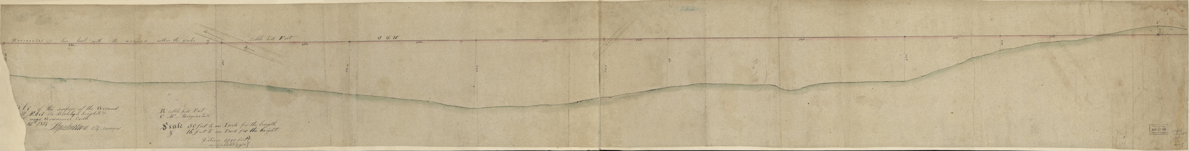
Profile of the Surface of the Ground at Cobble Hill Fort On Broklyn Heights & Mr. Bergen's Hill Near Gowannes Creek ... 12th in 1814
- Regular price
-
$67.95 - Regular price
-
$62.95 - Sale price
-
$67.95
Shipping calculated at checkout.
Buy one map, get any other map in our collection for 50% OFF! Add to cart to see discount.
Couldn't load pickup availability
About This Map
Old manuscript map of Cobble Hill, Cobble Hill (New York), Gowanus Canal, Gowanus Canal (New York), New York, New York (State), United States.
Created by Stephen Ludlam, United States. War Department. Office of the Chief of Engineers in 1814.
Created by Stephen Ludlam, United States. War Department. Office of the Chief of Engineers in 1814.
- Relief shown pictorially.
- Pen-and-ink, pencil, and watercolor.
- "B: Cobble Hill Fort, C: Mr Bergens hill."
- "Office of Chief of Engineers, War Department. 58510 538" on verso.
- Copy This map has some imperfections: lower right corner and portion of title lacking. We'll do our best to restore the image before printing.
- Minimal level cataloging record.
Map Sizing Information
- For the best legibility, order your map in the original size or larger. Most maps have intricate detail and small text that is best appreciated when the print size hasn't been reduced.
- Sizes labeled "Fits a Standard Frame" will drop right into any frame that you purchase in that size. The sizes that we offer are commonly available online and at most retail stores.
- Our standard sizes are recommendations based on the aspect ratio of the original map, but still may require some added "white space" in one dimension to fit.
- Non-standard sizes will require custom framing, and we suggest taking your print to the frame shop of your choice after you receive it for the best results.
- Custom sizes are available, simply contact us for a quote.
Below is an approximation of the scale of a few standard sizes, and how they might appear in your space.
