
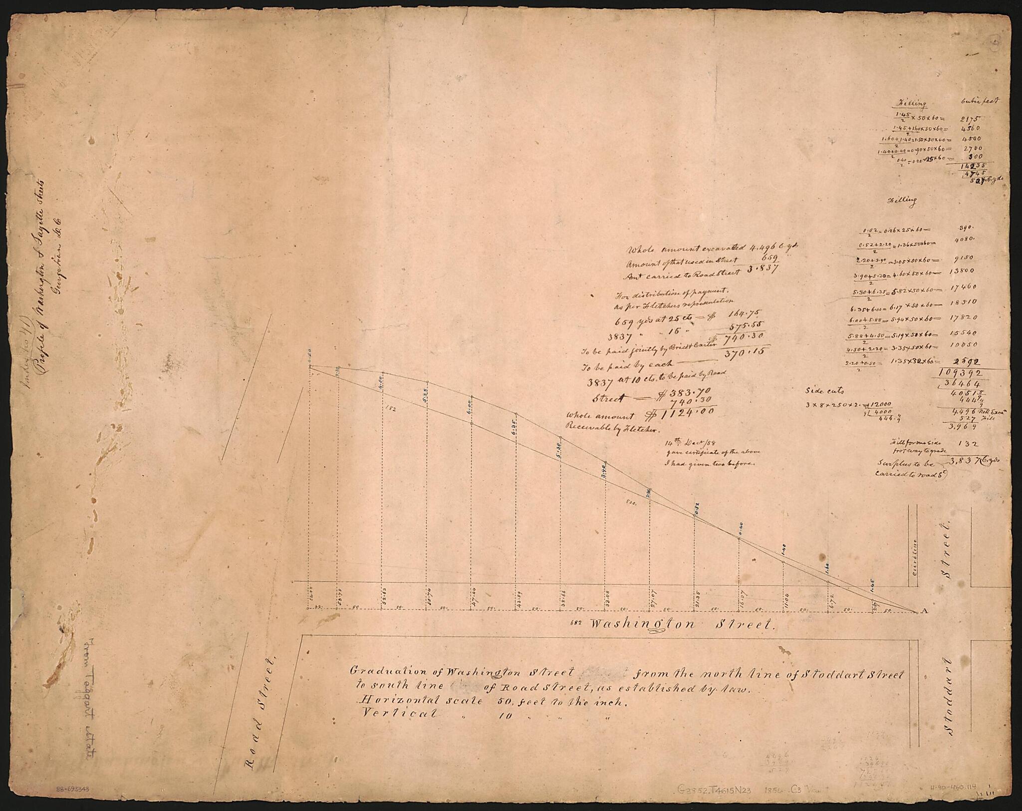
Profile of Washington & Fayette Streets, Georgetown, D.C 1856
- Regular price
-
$61.95 - Regular price
-
$43.95 - Sale price
-
$61.95
Shipping calculated at checkout.
Buy one map, get any other map in our collection for 50% OFF! Add to cart to see discount.
Couldn't load pickup availability
About This Map
Old map of District of Columbia, Fifth Street, Thirtieth Street, Thirty, United States, Washington, Washington D.C..
Created by Lewis Carbery, Hugh T. (Hugh Thomas) Taggart in 1856.
Created by Lewis Carbery, Hugh T. (Hugh Thomas) Taggart in 1856.
- Washington Street profile covers 30th Street between Q and R streets N.W. Fayette Street profile covers 35th Street between Volta Place and Wisconsin Avenue N.W.
- Alternate title: Profile of Washington & Fayette streets.
- Oriented with north to the left.
- Black, brown, blue inks, and lead pencil.
- Soiled and cracked at edges.
- Includes notes, statistical tables, computations, and outline maps of both streets.
- Phillips. Washington 498
Map Subjects
Charts Diagrams Etc
District Of Columbia
Manuscript Maps
Maps Manuscript
Streets
Thirtieth Street (Washington D.C.)
Fifth Street (Washington D.C.)
United States
Washington
Washington (D.C.)
Fifth Street
Thirtieth Street
Thirty
Washington D.C.
Lewis Carbery
Hugh T. (Hugh Thomas) Taggart
1856
Map Sizing Information
- For the best legibility, order your map in the original size or larger. Most maps have intricate detail and small text that is best appreciated when the print size hasn't been reduced.
- Sizes labeled "Fits a Standard Frame" will drop right into any frame that you purchase in that size. The sizes that we offer are commonly available online and at most retail stores.
- Our standard sizes are recommendations based on the aspect ratio of the original map, but still may require some added "white space" in one dimension to fit.
- Non-standard sizes will require custom framing, and we suggest taking your print to the frame shop of your choice after you receive it for the best results.
- Custom sizes are available, simply contact us for a quote.
Below is an approximation of the scale of a few standard sizes, and how they might appear in your space.

