
Qi Sheng Yan Hai Tu in 1881
- Regular price
-
$223.95 - Regular price
-
$218.95 - Sale price
-
$223.95
Shipping calculated at checkout.
Buy one map, get any other map in our collection for 50% OFF! Add to cart to see discount.
Couldn't load pickup availability
About This Map
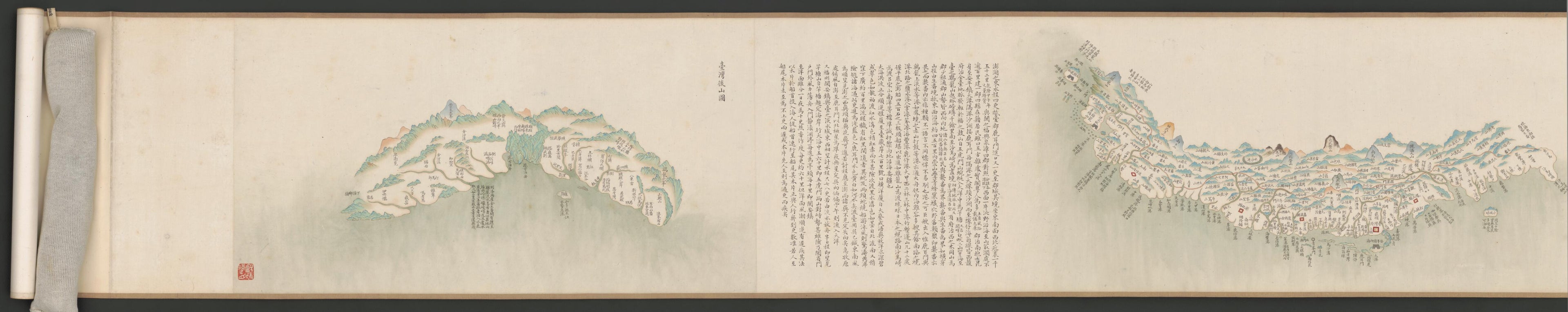
Old map of China, Eastern Hemisphere, Hainan Sheng, Macau (Special Administrative Region), Penghu County, Taiwain, Taiwan.
names and other details suggest that this map dates from 1787-1820. An introductory text states that it was compiled in the interest of coastal defense. The scroll map contains hundreds of place-names and is intended to be read from right to left. Interspersed at irregular intervals are notes on sea routes and sailing directions. Distances are given in li, a measure that has changed length over time. The quality of the calligraphy and the cartography suggest that the map was made for the emperor. Shown here is the mouth of the Zhu Jiang (Pearl River) and the Macau area. The text reads: "The coastal region of Xing Hui and Hu Men in Canton Province consists of an important strategic point, which should be given sufficient defense attention. This region is heavily infested with inner river bandits and sea pirates who can sail in and out freely. It also shares a border with Macau, where foreign boats and ships visit frequently. Those foreign vessels are always to be guarded against." The oldest permanent European settlement in Asia, Macau was established in 1557 by the Portuguese, who at that time dominated European trade with Asia." World Digital Library.
Created by Arthur W. (Arthur William) Hummel in 1881.
- Hummel purchase 1934, no. 1.
- Includes text.
- Insets: Huan hai quan tu -- Qi sheng yan hai quan tu -- Qiongzhou tu -- Penghu tu -- Taiwan tu -- Taiwan hou shan tu.
- Oriented with north to the right.
- Pictorial map.
- Relief shown pictorially.
- Title pasted on verso.
- Translated title: Coastal map of China.
- Scale ca. 1:760,000.
- Previous call number:: G7822.C6A5 1820 .Q5 Vault Shelf
Map Sizing Information
- For the best legibility, order your map in the original size or larger. Most maps have intricate detail and small text that is best appreciated when the print size hasn't been reduced.
- Sizes labeled "Fits a Standard Frame" will drop right into any frame that you purchase in that size. The sizes that we offer are commonly available online and at most retail stores.
- Our standard sizes are recommendations based on the aspect ratio of the original map, but still may require some added "white space" in one dimension to fit.
- Non-standard sizes will require custom framing, and we suggest taking your print to the frame shop of your choice after you receive it for the best results.
- Custom sizes are available, simply contact us for a quote.
Below is an approximation of the scale of a few standard sizes, and how they might appear in your space.
