
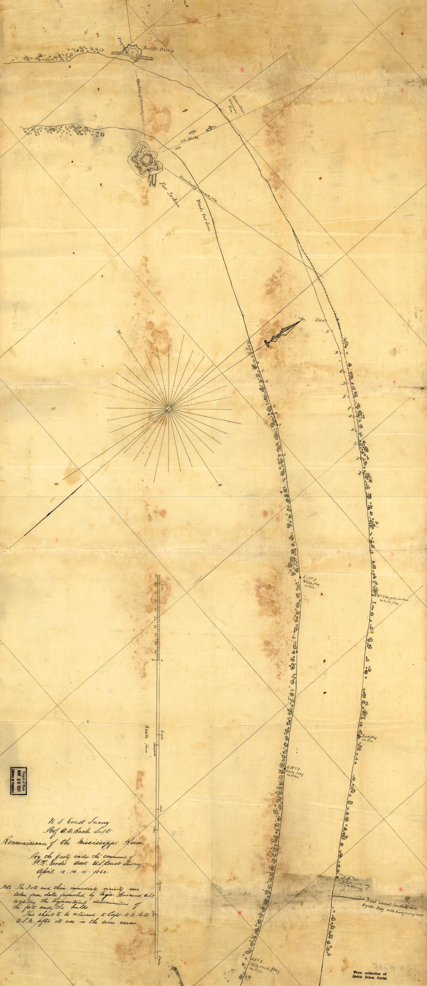
Reconnoissance of the Mississippi River Below Forts Jackson and St. Philip : Made Previous to the Reduction by the U.S. Fleet, Under the Command of Flag Officer D.G. Farragut, U.S.N 1862
- Regular price
-
$79.95 - Regular price
-
$74.95 - Sale price
-
$79.95
Shipping calculated at checkout.
Buy one map, get any other map in our collection for 50% OFF! Add to cart to see discount.
Couldn't load pickup availability
About This Map
Old map of Fort Jackson Region, Louisiana, Mississippi River, United States.
Created by A. D. (Alexander Dallas) Bache, Bowen & Co, F. H. Gerdes, Joseph R. (Joseph Roswell) Hawley, United States Coast Survey in 1862.
Created by A. D. (Alexander Dallas) Bache, Bowen & Co, F. H. Gerdes, Joseph R. (Joseph Roswell) Hawley, United States Coast Survey in 1862.
- At head of title: U.S. Coast Survey. Prof. A. D. Bache, Supt.
- Pen and ink manuscript drawn on tracing cloth, covering the environs of forts St. Philip and Jackson, Louisiana.
- "Note: The forts and their immediate vicinity were taken from data furnished by Major Barnard, U.S.E., excepting the trigonometrical determinations of the forts and the hulks. This chart to be returned to Capt. D. D. Porter, U.S.N., after its use in the river ceases."
- Civil War Map
Map Sizing Information
- For the best legibility, order your map in the original size or larger. Most maps have intricate detail and small text that is best appreciated when the print size hasn't been reduced.
- Sizes labeled "Fits a Standard Frame" will drop right into any frame that you purchase in that size. The sizes that we offer are commonly available online and at most retail stores.
- Our standard sizes are recommendations based on the aspect ratio of the original map, but still may require some added "white space" in one dimension to fit.
- Non-standard sizes will require custom framing, and we suggest taking your print to the frame shop of your choice after you receive it for the best results.
- Custom sizes are available, simply contact us for a quote.
Below is an approximation of the scale of a few standard sizes, and how they might appear in your space.

