
Road and Military Map of the United States, Mexico, the West Indies, &c 1862
- Regular price
-
$143.95 - Regular price
-
$138.95 - Sale price
-
$143.95
Shipping calculated at checkout.
Buy one map, get any other map in our collection for 50% OFF! Add to cart to see discount.
Couldn't load pickup availability
About This Map
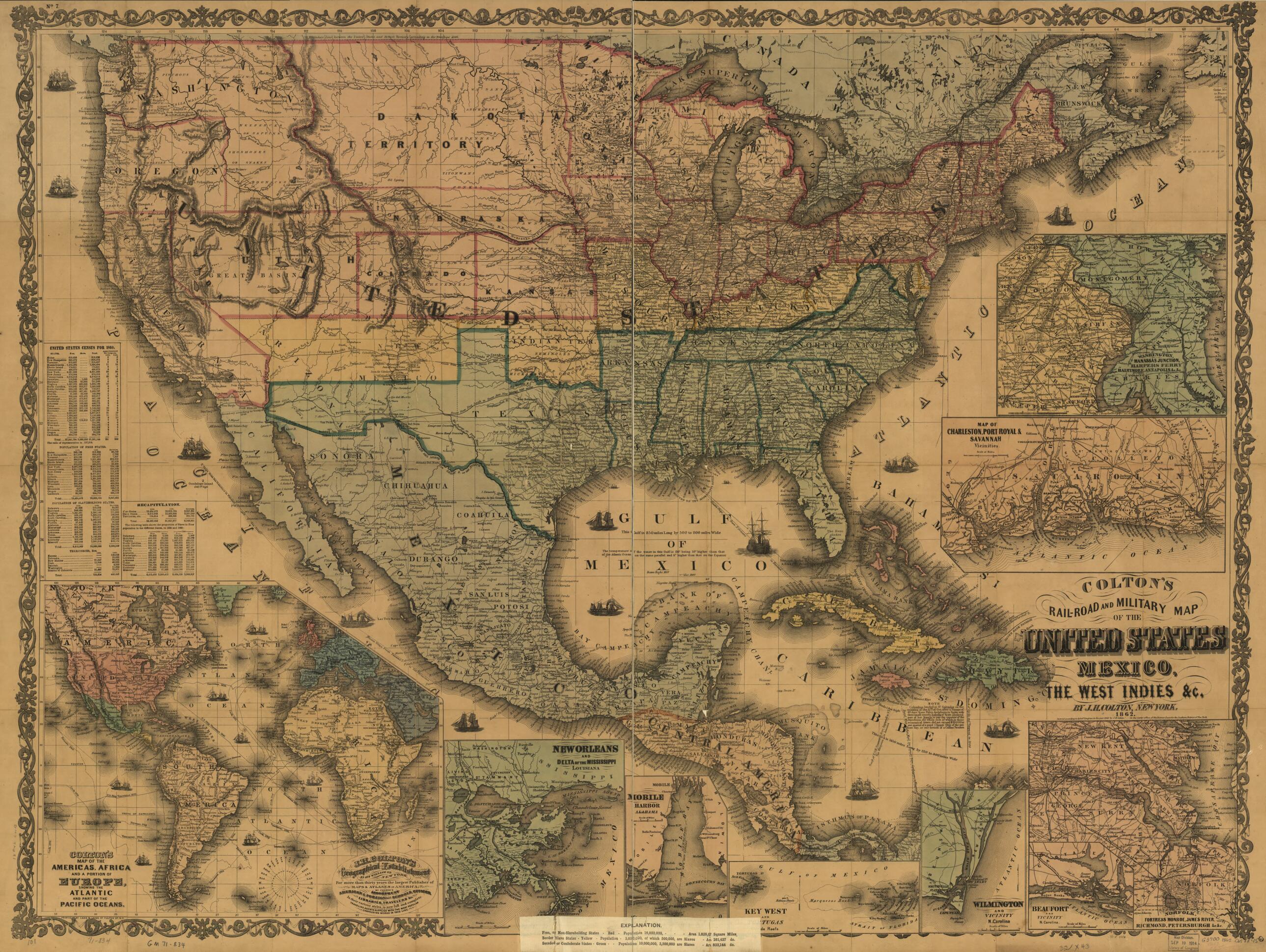
Old map of Mexico, United States, West Indies.
Detailed general map of portions of North America framed in decorative borders showing drainage, international and state boundaries, cities and towns, forts, railroads in operation, and proposed lines. [From published bibliography]
Created by J. H. (Joseph Hutchins) Colton in 1862.
Detailed general map of portions of North America framed in decorative borders showing drainage, international and state boundaries, cities and towns, forts, railroads in operation, and proposed lines. [From published bibliography]
Created by J. H. (Joseph Hutchins) Colton in 1862.
- Scale ca. 1:6,500,000.
- Relief shown by hachures.
- Shows slave holding states.
- Civil War Map
- Includes census information for 1860.
- Insets: Colton's map of the Americas, Africa and a portion of Europe showing the Atlantic and part of the Pacific oceans.--New Orleans and delta of the Mississippi, Louisiana.--Mobile harbor, Alabama.--Key West and Tortugas, Florida reefs.--Wilmington and vicinity, N. Carolina.--Beaufort and vicinity, N. Carolina.--Norfolk, fortress Monroe, James River, Richmond, Petersburg &c &c.--Map of Charleston, Port Royal & Savannah vicinities.--Washington, Manassas Junction, Harpers Ferry, Baltimore, Annapolis &c &c.
Map Sizing Information
- For the best legibility, order your map in the original size or larger. Most maps have intricate detail and small text that is best appreciated when the print size hasn't been reduced.
- Sizes labeled "Fits a Standard Frame" will drop right into any frame that you purchase in that size. The sizes that we offer are commonly available online and at most retail stores.
- Our standard sizes are recommendations based on the aspect ratio of the original map, but still may require some added "white space" in one dimension to fit.
- Non-standard sizes will require custom framing, and we suggest taking your print to the frame shop of your choice after you receive it for the best results.
- Custom sizes are available, simply contact us for a quote.
Below is an approximation of the scale of a few standard sizes, and how they might appear in your space.

