
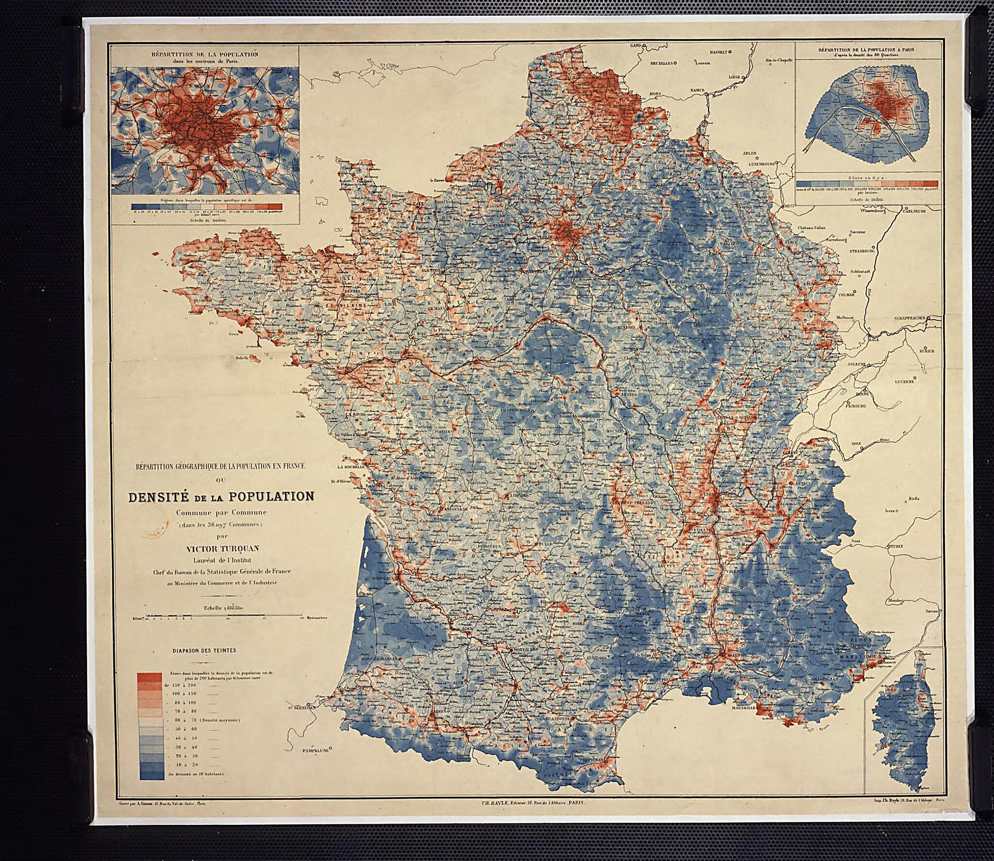
Geographical Distribution of the Population In France, Or Population Density by Commune. (Répartition Géographique De La Population En France Ou Densité De La Population Par Commune) 1887
- Regular price
-
$49.95 - Regular price
-
$34.95 - Sale price
-
$49.95
Buy one map, get any other map in our collection for 50% OFF! Add to cart to see discount.
Couldn't load pickup availability
About This Map
Discover the timeless beauty of our fine art quality printed reproduction of this antique map. Perfect for history enthusiasts, collectors, and interior decorators.
Restored with meticulous attention to detail by our team with over a decade of experience, this stunning reproduction captures the intricate artistry and historical significance of the original map.
Whether you're a collector or seeking a unique decor piece, this archival-quality map reproduction is a timeless addition to any space. Order now to bring history to life!
Old map of France.19?) headed the French Statistical Bureau from 1887 to 1896. He wrote numerous works on economic and demographic statistics, which included maps with graded coloration and iso-lines (lines connecting points with equal values). For Turquan, "the study of population distribution within the territory of a country belongs as much to geography as to statistics." In an era in which color rarely was used even in statistical charts, he created this map of the population distribution in France using isopleths (lines surrounding zones with similar features) and "pitches of color" to draw the different regions. Turquan's powers of visualization and the aesthetic quality of his maps made his work stand out from that of other statisticians of his time, and prefigured the more systematic development of quantitative cartography in the 20th century.
Created by Victor Turquan in 1887.
- Title devised, in English, by Library staff.
- "Scale 1:1 600 000"--Note extracted from World Digital Library.
- Original resource extent: Printed map, color, 65 x 72 centimeters.
- Original resource at: National Library of France.
- Content in French.
- Description based on data extracted from World Digital Library, which may be extracted from partner institutions.
Map Subjects
France
Population Density
Victor Turquan
1887
- For the best legibility, order your map in the original size or larger. Most maps have intricate detail and small text that is best appreciated when the print size hasn't been reduced.
- Sizes labeled "Fits a Standard Frame" will drop right into any frame that you purchase in that size. The sizes that we offer are commonly available online and at most retail stores.
- Our standard sizes are recommendations based on the aspect ratio of the original map, but still may require some added "white space" in one dimension to fit.
- Non-standard sizes will require custom framing, and we suggest taking your print to the frame shop of your choice after you receive it for the best results.
- Custom sizes are available, simply contact us for a quote.
Below is an approximation of the scale of a few standard sizes, and how they might appear in your space.

