
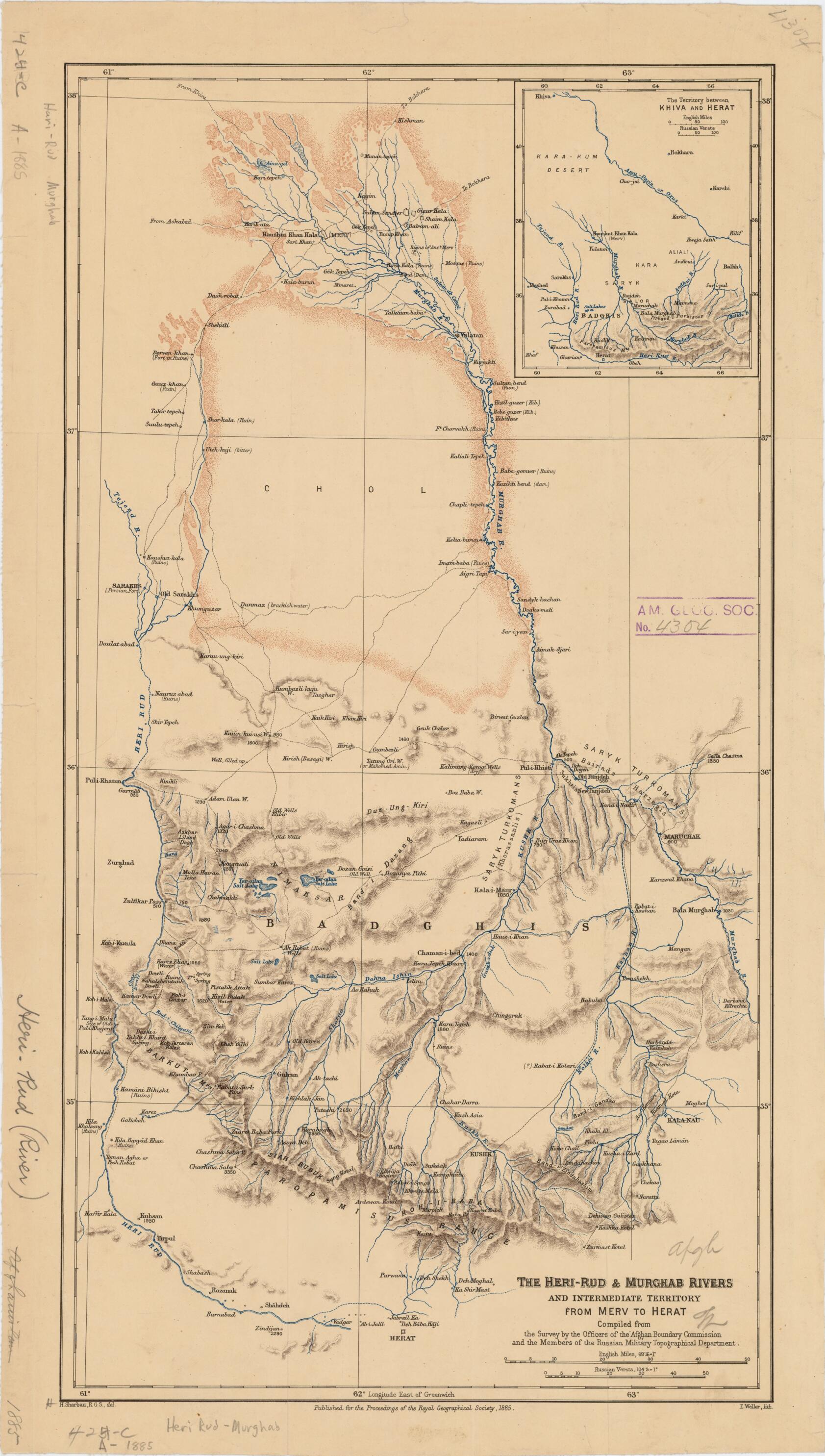
Rud and Murghab Rivers and Intermediate Territory from Merv to Herat 1885
- Regular price
-
$54.95 - Regular price
-
$30.95 - Sale price
-
$54.95
Shipping calculated at checkout.
Buy one map, get any other map in our collection for 50% OFF! Add to cart to see discount.
Couldn't load pickup availability
About This Map
Old map of Afghanistan, Turkmenistan, Uzbekistan.
-Persian War of 1856--57. Under the terms of 1857 Treaty of Paris, the Persians were compelled to withdraw from Herat, leaving the city under Afghan control. Britain's interest in Herat was linked to the intense rivalry between it and Russia in what has come to be known as the Great Game. The object of this rivalry was the control of Central Asia. The annexation of Merv by imperial Russia in 1884 sent waves of concern reverberating throughout the British Empire. The British feared that from Merv the Russians had gained new access to British India via the Hari Rud valley and the city of Herat. The map depicts the Badghis region and surrounding areas stretching from the Merv oasis in the north to Herat in the south, an area of great strategic concern for the British in 1885. The map was compiled from a survey conducted by the Afghan Boundary Commission, a joint British and Russian body, and was published in 1885 by the Royal Geographical Society in London. The scale is given in miles and versts, a Russian unit of measurement equal to 1.07 kilometers.
Created by Afghan Boundary Commission, Royal Geographical Society (Great Britain), Russia. General Staff. Military Topography Directorate, Henry Sharbau, Edward Weller in 1885.
- Title devised, in English, by Library staff.
- "Scale about 1:800,000"--Note extracted from World Digital Library.
- Original resource extent: 1 map : color ; 53 x 28 centimeters.
- Original resource at: University of Wisconsin-Milwaukee Libraries.
- Content in English.
- Description based on data extracted from World Digital Library, which may be extracted from partner institutions.
Map Sizing Information
- For the best legibility, order your map in the original size or larger. Most maps have intricate detail and small text that is best appreciated when the print size hasn't been reduced.
- Sizes labeled "Fits a Standard Frame" will drop right into any frame that you purchase in that size. The sizes that we offer are commonly available online and at most retail stores.
- Our standard sizes are recommendations based on the aspect ratio of the original map, but still may require some added "white space" in one dimension to fit.
- Non-standard sizes will require custom framing, and we suggest taking your print to the frame shop of your choice after you receive it for the best results.
- Custom sizes are available, simply contact us for a quote.
Below is an approximation of the scale of a few standard sizes, and how they might appear in your space.

