
Izobrazhenie Zemnogo Globusa. (Изображение земного глобуса.) 1750
- Regular price
-
$68.95 - Regular price
-
$63.95 - Sale price
-
$68.95
Buy one map, get any other map in our collection for 50% OFF! Add to cart to see discount.
Couldn't load pickup availability
About This Map
Discover the timeless beauty of our fine art quality printed reproduction of this antique map. Perfect for history enthusiasts, collectors, and interior decorators.
Restored with meticulous attention to detail by our team with over a decade of experience, this stunning reproduction captures the intricate artistry and historical significance of the original map.
Whether you're a collector or seeking a unique decor piece, this archival-quality map reproduction is a timeless addition to any space. Order now to bring history to life!
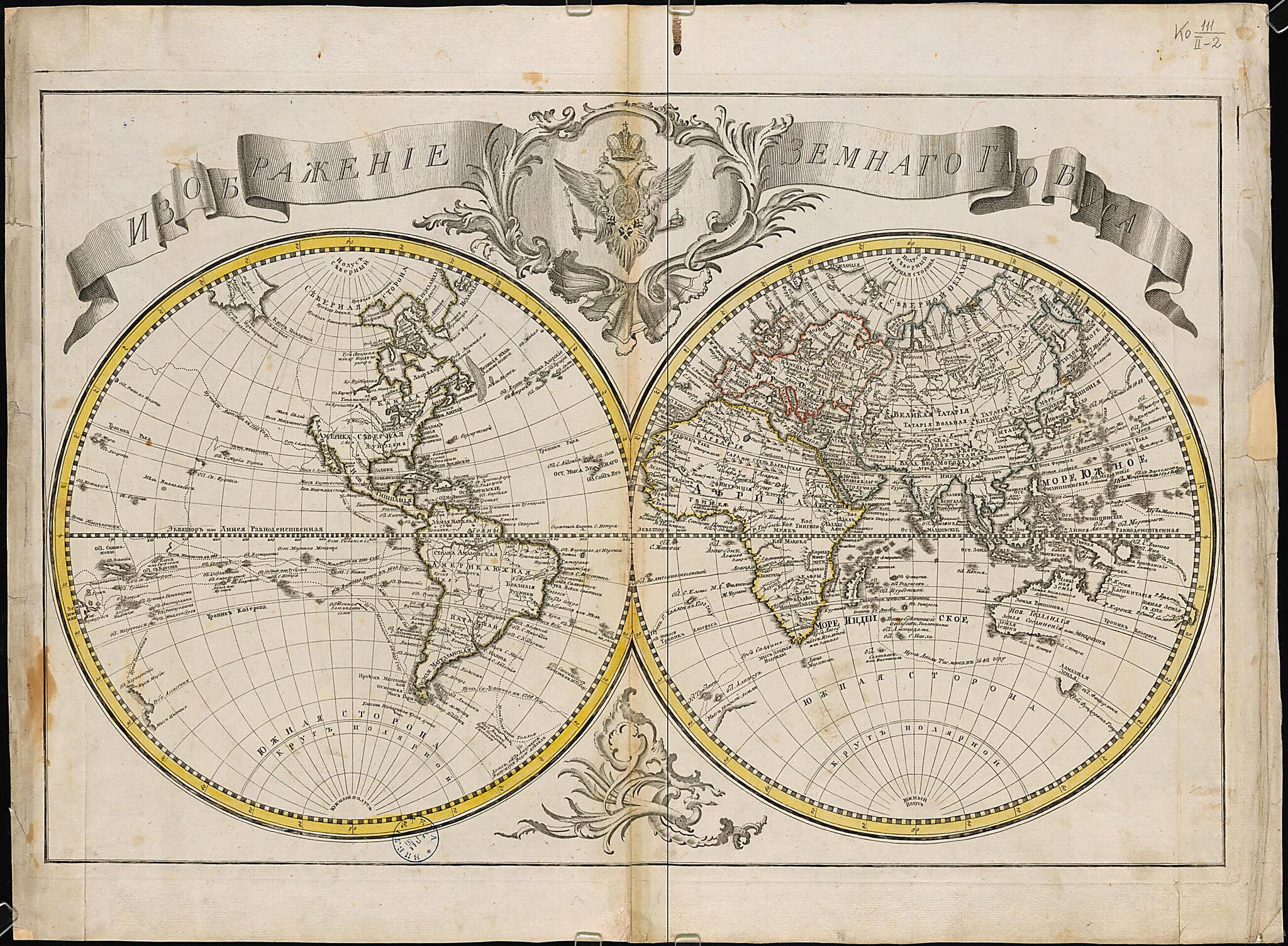
Old map of Primorskiy Krai, Russian Federation.18th century. The observations made on the voyages of Semen Dezhnev and Vitus Bering to Alaska were not then well known, and thus the map entirely omits northwestern North America, as that region was then still unknown to the European world. The globe is printed on a single sheet by being split into two halves, roughly the eastern and western hemispheres. In order to include all of Europe and Africa on one side, the map does not divide naturally along the prime meridian. A double-headed eagle, holding the orb and scepter of the Russian state, adorns the top of the map. All place-names are in Russian and broadly follow standard cartographic conventions of the era. Geographic knowledge of Europe and Russia (excluding the northeasternmost parts of Siberia) was understandably more accurate and extensive for Russian cartographers in that period than knowledge of other parts of the world, and thus these parts of the map are the most detailed. The map also includes elements of the known Scandinavian, Russian, and Canadian Arctic, including Spitsbergen, Novaya Zemlya, and Greenland, as well as rough sketches of Hudson Bay and Baffin Bay. It does not, of course, include the western Arctic near and including Alaska (other than the Diomede Islands in the Bering Strait, already discovered on early Russian voyages), eastern Australasia, nor any portions of Antarctica. Several long voyages and circumnavigations are shown by dotted lines, including Ferdinand Magellan's initial round-the-world voyage of 1519-22. World Digital Library.
- Kartograficheskai︠a︡ setka: Ferro.
- Zaglavie v kartushe s gerbom Rossiĭskoĭ Imperii. Granit︠s︡y chasteĭ sveta i polushariĭ raskrasheny ot ruki. V seredine 18 veka eshche slabo byla izuchena severo-vostochnai︠a︡ chast' Rossiĭskoĭ Imperii, byli neizvestny mori︠a︡ i prolivy, razdeli︠a︡i︠u︡shchie Evro-Azii︠u︡ ot Severnoĭ Ameriki. Ne pokazano zapadnoe i severnoe poberezh'e Severnoĭ Ameriki. Ostaetsi︠a︡ neizvestnym vostochnoe poberezh'e Avstralii. Idet izuchenie mira. Poėtomu na karte privedeny marshruty vazhneĭshikh puteĭ.
- Original map at: Russian State Library
- Картографическая сетка: Ферро.
- Заглавие в картуше с гербом Российской Империи. Границы частей света и полушарий раскрашены от руки. В середине 18 века еще слабо была изучена северо-восточная часть Российской Империи, были неизвестны моря и проливы, разделяющие Евро-Азию от Северной Америки. Не показано западное и северное побережье Северной Америки. Остается неизвестным восточное побережье Австралии. Идет изучение мира. Поэтому на карте приведены маршруты важнейших путей.
Map Subjects
Primorskiy Krai
Russian Federation
World Maps
1750
- For the best legibility, order your map in the original size or larger. Most maps have intricate detail and small text that is best appreciated when the print size hasn't been reduced.
- Sizes labeled "Fits a Standard Frame" will drop right into any frame that you purchase in that size. The sizes that we offer are commonly available online and at most retail stores.
- Our standard sizes are recommendations based on the aspect ratio of the original map, but still may require some added "white space" in one dimension to fit.
- Non-standard sizes will require custom framing, and we suggest taking your print to the frame shop of your choice after you receive it for the best results.
- Custom sizes are available, simply contact us for a quote.
Below is an approximation of the scale of a few standard sizes, and how they might appear in your space.

